Maps of Castile and León

Regna Hispaniarum, atque Portugalliæ, 1
1 Blatt : 53 x 64 cm Gerard Valck
Spanien NO.
1 : 1800000 Berghaus, Heinrich; Flemming, Carl; Sohr, Karl; Theinert, A.
Novissima et accuratissima tabula, quâ Gallæciæ et Legionis regna, Asturiarum principa.tus Portugalliæ tractus septentrionalis
1 Karte : Kupferdruck ; 46 x 58 cm Ottens; Ottens R. et J. Ottens
Corona Portugalliae cum ei affinibus Regnis Hispanicis : Don Pedro generosissimo regi Portugalliae dedicatur
1 : 1100000 per Jacobum Robyn Amst. Bat. Luggerdus van Anse schulp. Amst. Bat. : per Jacobum Robyn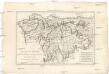
La Galice, les Asturies, le r. de Léon, la Castille Vieille et la Biscaye
1 : 7660000 Asturie (Španělsko) Bonne, Rigobert André
Regnorum Castellæ veteris, Legionis, et Gallæciæ principatuumq[ue] Biscaiæ, et Asturiarum accuratissima descriptio
1 Karte : Kupferdruck ; 48 x 56 cm Wit ex officina J. Cóvens et C. Mortier
Regnorum Castellæ veteris, Legionis, et Gallæciæ principatuumq[ue] Biscaiæ, et Asturiarum accuratissima descriptio
1 Karte : Kupferdruck ; 48 x 56 cm Wit ex officina Frederici de Wit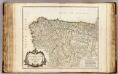
Castille septentrionale.
1 : 1250000 Robert de Vaugondy, Gilles, 1688-1766

A new Military Map of Spain and Portugal compiled from The Nautical Surveys of Don Vincent Tofiño, the new Provincial maps of Don Tomas Lopez, the large map of the Ptrenees by Roussill, and various original documents
1 Mapa en 4 seccions dins d'un estoig. John Stockdale J. Stockdale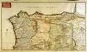
Regnorum Castellæ veteris Legionis et Gallæciæ principatuumq[ue] Biscaiæ et Asturiarum accuratissima descriptio
1 Karte auf 2 Blatt : Kupferdruck ; 46 x 81 cm Visscher Nicolaes Visscher
Theatre de la guerre en Portugal, et dans les Algarves
1 Blatt : 51 x 63 cm Covens et Mortier
[Spanien und Portugal in 4 Blättern, Blatt 1]
Handatlas über alle Theile der Erde und über das Weltgebäude Stieler, Adolf Justus Perthes
Les estats de la couronne de Castille, dans les parties plus septentrionales de l'Espagne
1 Karte : Kupferdruck ; 40 x 53 cm Sanson; Somer chez l'auteur
[Spanien und Portugal, Blatt 1]
Adolf Stieler's Handatlas über alle Theile der Erde und über das Weltgebäude Stieler, Adolf Justus Perthes
Spain. Espana I.
1 : 1800000 Society for the Diffusion of Useful Knowledge (Great Britain)
[Spanien und Portugal in 4 Blättern]
Hand-Atlas über alle Theile der Erde nach dem neuesten Zustande und über das Weltgebäude Stieler, Adolf bei Justus Perthes
Bassins du Douro et du Minho
1 : 2200000 Vuillemin, Alexandre Aimé 1812-1880 Paris : Imprimerie et Librairie [Delalain]
Regnorum Castellae veteris, legionis, et Gallaeciae principatuumque Biscaiae, et Asturiarum accuratissima descriptio
1 : 1400000 per F. de Wit Amstelodami : ex officina Frederici de Wit
Partie septentrionale du royaume de Portugal, les royaumes de Leon et de Galice, les Asturies, partie des deux Castilles [et]c
1 Karte : Kupferdruck ; 44 x 56 cm Jaillot; Dezauche chez Dezauche géog. rue des Noyers près celle des Anglois
Espagne et Portugal. Flle. N.O.
1 : 1250000 Vivien St Martin, L.
Spain, Portugal 1.
1 : 1774080 Letts, Son & Co.
Neueste Generalkarte von Portugal und Spanien, 1
1 Blatt : 69 x 51 cm Schrämbl
Regnorum Castellæ veteris Legionis et Gallæciæ principatuumque Biscaiæ et Asturiarum accuratissima descriptio, 1
1 Blatt : 48 x 41 cm Visscher
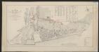
Mapa de Galicia con las nuevas divisiones
1 Mapa. Atlas Nacional de España Dufour, A.H. 0
Castilla la Vieja con las nuevas divisiones
1 Mapa. Atlas Nacional de España Dufour, A.H. 0
Legionis Regnum et Asturiarum Principatus. [Karte], in: Novus Atlas, das ist, Weltbeschreibung, Bd. 2, S. 222.
1 Karte aus Atlas Blaeu, Joan Blaeu, Willem Janszoon
Legionis Regnum et Asturiarum Principatus. [Karte], in: Theatrum orbis terrarum, sive, Atlas novus, Bd. 2, S. 220.
1 Karte aus Atlas Blaeu, Joan Blaeu, Willem Janszoon
Legionis Regnum et Asturiarum Principatus. [Karte], in: Novus atlas absolutissimus, Bd. 6, S. 31.
1 Karte aus Atlas Janssonius Offizin