Maps of Huelva
Mapa general del reyno de Portugal, 4
2 Blätter : 35 x 78 cm Tomás López
Mappa ou carta geographica dos reinos de Portugal e Algarve, 5
1 Blatt : 55 x 44 cm Dury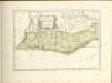


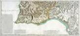
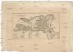
Mapa del reyno de Algarve
1 Karte : Kupferdruck ; 33 x 28 cm López s.n.
Sevilla
Sevilla (Španělsko) Florimi, Matteo Matteo florimi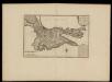
Plan de la ville de Cadis
Beaurain, Jean, chevalier de
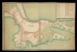
Plano industrial y comercial de la ciudad de Jerez de la Frontera / propiedad de J. Calvet y Boix
1 : 5000 Calvet y Boix, Juan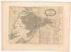
Plan de la ville de Cadix
Plan der Stadt und Befestigungen von Cadix
Cádiz (Španělsko)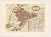
Plan de la ville de Cadix
Cadix: plànol de la ciutat i les seves fortificacions
1 manuscrit. Text en francèsDatat al s. XVIII.
Cadiz [títol afegit en llapis, possiblement posteriorment]
1 manuscrit. Datat al s. XIX. 0 0
Plaan vande dissante of landing in Spangien voor Cadix met de campementen en marse door den Hertog van Ormont en den Generaal Majoor en Baron de Spar gedaan ceedert den 26 Augustus tot den 27. Septem[be]r anno 1702
1 : 48200 geteekent door L. du Mee, Ordinaris Ingenjeur J. v. Call fec.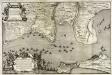
Plan de Cadix, de la baye, du Puntal de Port Marie, de Rotta, [et] de l'entrèe de la riviere de Guadalete
1 Plan auf 2 Blatt : Kupferdruck ; 48 x 72 cm chez Alberts et van der Kloot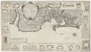
Plan de la baye et ville de Cadis de la riviere de St. Lucas de Barameda de ses environs
Beaurain
Plan der Bay von Cadiz
Cádiz (Španělsko)
Plan der Bay von Cadiz
Cádiz (Španělsko)
Plan der Bay von Cadiz
Cádiz (Španělsko)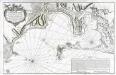
Carte hydrographique de la baye de Cadix
1 Karte : Kupferdruck ; 56 x 88 cm Bellin s.n.
Kaart van de Baay van Cadix met de plans der fortificatien
1 : 15000 ten dienst der zeevaart opgesteld door William May, Luit. ter Zee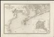
Mapa de los alrededores de Cádiz
1 : 36000 compuesto por A.H. Dufour la topografia grabada por Ch. Dyonnet ; la letra por Ch. Simon Cadiz [etc.] : Bulla
Parte meridional do reyno de Portugal
1 Karte : Kupferdruck ; 40 x 52 cm Sanson em casa del autor
Provincias meridionales regni Portugalliae, scilicet Extremadura, Transtagana quibus regnum Algarbiae adiungitur
1 Mapa. Atlas von Spanien. Homannischen Erben ; Güssefeld, Franz Ludwig
Carta de Portugal, aprovada para uso das escolas / Direccâo Geral dos Trabalhos Geodesicos e Topographicos
1 : 500000 Direcçâo Geral dos Trabalhos Geodesicos e Topographicos
[Carte d'Espagne et de Portugal en neuf feuilles, 7]
1 Blatt : 31 x 41 cm P.G. Chanlaire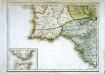
Espagne et Portugal, 7
1 Blatt : 31 x 42 cm Mentelle
Partie meridionale du royaume de Portugal
1 Karte : Kupferdruck ; 47 x 52 cm Bellin; Santini; Remondini chez M. Remondini
Provincias meridionales regni Portugalliæ, scilicet Extremadura, Transtagana, quibus regnum Algarbiæ adiungitur
1 Karte : Kupferdruck ; 54 x 44 cm Güssefeld; López Homann. haered


