Maps of Argyll and Bute

Cantyra chersonesus
1 Karte : Kupferdruck ; 40 x 48 cm Blaeu; Pont Joan Blaeu
CANTYRA | Chersonesus, | CANTYR | a Demie-yland
Auctor Timoth. Pont. [Amsterdam : Joan Blaeu]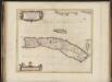
Cantyra Chersonesus, [vulgo], Cantyr, a Demie-yland / auctor Timoth. Pont.
Pont, Timothy, 1560?-1614? Blaeu, Joan, 1596-1673
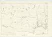
Kintyre - OS One-Inch Map
1 : 63360 Topographic maps Ordnance Survey Ordnance Survey
Kintyre (76) - OS One-Inch map
1 : 63360 Topographic maps Ordnance Survey Ordnance Survey
Kintyre (76) - OS One-Inch map
1 : 63360 Topographic maps Ordnance Survey Ordnance Survey
Knapdale - OS One-Inch Map
1 : 63360 Topographic maps Ordnance Survey Ordnance Survey
Bute and Arran - Bartholomew's 'Survey Atlas of Scotland'
1 : 126720 Topographic maps John Bartholomew & Son, Ltd John Bartholomew & Son, Ltd
Killean - OS One-Inch map
1 : 63360 Topographic maps Ordnance Survey Ordnance Survey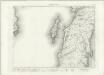
Killean - OS One-Inch map
1 : 63360 Topographic maps Ordnance Survey Ordnance Survey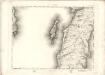
Kilean - OS One-Inch map
1 : 63360 Topographic maps Ordnance Survey Ordnance Survey
Campbelton - OS One-Inch map
1 : 63360 Topographic maps Ordnance Survey Ordnance Survey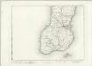
Campbelton - OS One-Inch map
1 : 63360 Topographic maps Ordnance Survey Ordnance Survey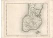
Campbelton - OS One-Inch map
1 : 63360 Topographic maps Ordnance Survey Ordnance Survey
Sound of Jura (70) - OS One-Inch map
1 : 63360 Topographic maps Ordnance Survey Ordnance Survey
Sound of Jura (70) - OS One-Inch map
1 : 63360 Topographic maps Ordnance Survey Ordnance Survey
West Loch Tarbert
Great Britain. Hydrographic Office
Gigha Sound
Great Britain. Hydrographic Office
NR72 - OS 1:25,000 Provisional Series Map
1 : 25000 Topographic maps Ordnance Survey Ordnance Survey
NR71 - OS 1:25,000 Provisional Series Map
1 : 25000 Topographic maps Ordnance Survey Ordnance Survey
Argyllshire, Sheet CCLXIII - OS 6 Inch map
1 : 10560 Topographic maps Ordnance Survey Ordnance Survey
Argyllshire, Sheet CCX - OS 6 Inch map
1 : 10560 Topographic maps Ordnance Survey Ordnance Survey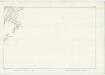
Argyllshire, Sheet CCXXXIII - OS 6 Inch map
1 : 10560 Topographic maps Ordnance Survey Ordnance Survey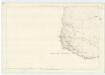
Argyllshire, Sheet CCLXIV - OS 6 Inch map
1 : 10560 Topographic maps Ordnance Survey Ordnance Survey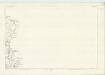
Argyllshire, Sheet CCXXI - OS 6 Inch map
1 : 10560 Topographic maps Ordnance Survey Ordnance Survey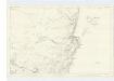
Argyllshire, Sheet CXCIX - OS 6 Inch map
1 : 10560 Topographic maps Ordnance Survey Ordnance Survey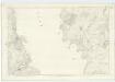
Argyllshire, Sheet CXCII - OS 6 Inch map
1 : 10560 Topographic maps Ordnance Survey Ordnance Survey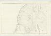
Argyllshire, Sheet CCXXXVII - OS 6 Inch map
1 : 10560 Topographic maps Ordnance Survey Ordnance Survey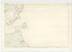
Argyllshire, Sheet CCLVIII - OS 6 Inch map
1 : 10560 Topographic maps Ordnance Survey Ordnance Survey