Maps of Argyll and Bute

Knapdalia provincia, que sub Argathelia censetur
1 Karte : Kupferdruck ; 41 x 52 cm Blaeu; Pont Joan Blaeu
Knapdalia Provincia que sub Argathelia censetur, [vel], The Province of Knapdail which is accounted a member of Argyll. Auct. Timoth. Pont.
Pont, Timothy, 1560?-1614? Blaeu, Joan, 1596-1673
KNAPDALIA | PROVINCIA, | que sub Argathelia censetur. | The Province of KNAPDAIL | which is accounted a member of Argyll.
Auct. Timoth. Pont. [Amsterdam : Joan Blaeu]
Loch Fyne
Great Britain. Hydrographic Office
Loch Awe - OS One-Inch Map
1 : 63360 Topographic maps Ordnance Survey Ordnance Survey
Dunoon & Loch Fyne (65) - OS One-Inch map
1 : 63360 Topographic maps Ordnance Survey Ordnance Survey
Dunoon & Loch Fyne (65) - OS One-Inch map
1 : 63360 Topographic maps Ordnance Survey Ordnance Survey
Rothesay - OS One-Inch map
1 : 63360 Topographic maps Ordnance Survey Ordnance Survey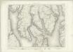
Rothesay - OS One-Inch map
1 : 63360 Topographic maps Ordnance Survey Ordnance Survey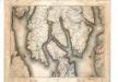
Rothesay - OS One-Inch map
1 : 63360 Topographic maps Ordnance Survey Ordnance Survey
Jura - OS One-Inch map
1 : 63360 Topographic maps Ordnance Survey Ordnance Survey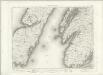
Jura - OS One-Inch map
1 : 63360 Topographic maps Ordnance Survey Ordnance Survey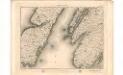
Jura - OS One-Inch map
1 : 63360 Topographic maps Ordnance Survey Ordnance Survey
Loch Crinan to Cuan Sound
Great Britain. Hydrographic Office
West Loch Tarbert
Great Britain. Hydrographic Office
Inveraray - OS One-Inch map
1 : 63360 Topographic maps Ordnance Survey Ordnance Survey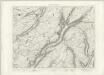
Inveraray - OS One-Inch map
1 : 63360 Topographic maps Ordnance Survey Ordnance Survey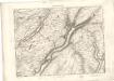
Inveraray - OS One-Inch map
1 : 63360 Topographic maps Ordnance Survey Ordnance Survey
NS06 - OS 1:25,000 Provisional Series Map
1 : 25000 Topographic maps Ordnance Survey Ordnance Survey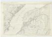
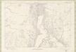
Argyllshire, Sheet CLI - OS 6 Inch map
1 : 10560 Topographic maps Ordnance Survey Ordnance Survey
Argyllshire, Sheet CL - OS 6 Inch map
1 : 10560 Topographic maps Ordnance Survey Ordnance Survey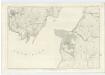
Argyllshire, Sheet CLXXI - OS 6 Inch map
1 : 10560 Topographic maps Ordnance Survey Ordnance Survey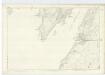
Argyllshire, Sheet CXC - OS 6 Inch map
1 : 10560 Topographic maps Ordnance Survey Ordnance Survey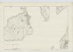
Argyllshire, Sheet CXXXVII - OS 6 Inch map
1 : 10560 Topographic maps Ordnance Survey Ordnance Survey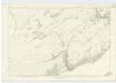
Argyllshire, Sheet CXL - OS 6 Inch map
1 : 10560 Topographic maps Ordnance Survey Ordnance Survey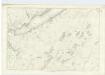
Argyllshire, Sheet CXXXIX - OS 6 Inch map
1 : 10560 Topographic maps Ordnance Survey Ordnance Survey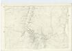
Argyllshire, Sheet CLXXII - OS 6 Inch map
1 : 10560 Topographic maps Ordnance Survey Ordnance Survey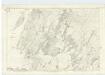
Argyllshire, Sheet CXLIX - OS 6 Inch map
1 : 10560 Topographic maps Ordnance Survey Ordnance Survey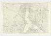
Argyllshire, Sheet CLXXXII - OS 6 Inch map
1 : 10560 Topographic maps Ordnance Survey Ordnance Survey