Maps of Skerryvore

Scotland / J. Ainslie, 4
1 Blatt : 67 x 58 cm Ainslie, Faden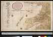
Nieuwe afteekening van de West kust van SchotLandt als mede een gedeelte van de Lewijs Eijlanden en Skie, Mulla, Tijrrif, Col int groot
Scotland Gerard van Keulen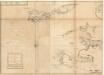
The west side of the island Mull with the islands Tiri and Coll.
Mackenzie, Murdoch (Senior), 1712-1797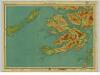
Mull & Iona, Sheet 10 - Bartholomew's "Half Inch to the Mile Maps" of Scotland
1 : 126720 Topographic maps John Bartholomew & Son, Ltd John Bartholomew & Son, Ltd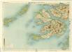
Mull, Sheet 10 - Bartholomew's "Half Inch to the Mile Maps" of Scotland
1 : 126720 Topographic maps Bartholomew, John George John Bartholomew & Co
Mvla insvla
1 Karte : Kupferdruck ; 41 x 53 cm Blaeu; Pont Joan Blaeu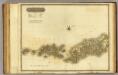
Western Isles S.
1 : 106000 Thomson, John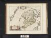
Mula Insula, quae ex Aebudarum numero una est, et Lochabriae ad occasum praetenditur. The Yle of Mul whiche is one of the Westerne Yles, and lyeth ovir against Lochabyr / Auct. Timoth. Pont.
Pont, Timothy, 1560?-1614? Blaeu, Joan, 1596-1673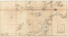
The west coast of Scotland from Ila to Mull.
Mackenzie, Murdoch (Senior), 1712-1797
VISTVS INSVLA, | vulgo VIIST, | cum aliis minoribus | EX ÆBVDARVM NVMERO | ei ad meridiem adjacentibus.
Auct. Timotheo Pont. [Amsterdam : Joan Blaeu]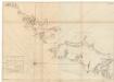
The south part of Long Island from Bara Head to Benbecula I.
Bowen, Thomas
Ardnamurchan - Bartholomew's 'Survey Atlas of Scotland'
1 : 126720 Topographic maps John Bartholomew & Son, Ltd John Bartholomew & Son, Ltd
Rum, Cuillins - Bartholomew's 'Survey Atlas of Scotland'
1 : 126720 Topographic maps John Bartholomew & Son, Ltd John Bartholomew & Son, Ltd
INSVLÆ QVÆDAM MINORES | ex Æbudis quæ MVLAM et SKIAM | insulas interjacent. | SOME OF THE SMALLER WESTERNE YLES, lying betweene the Yles of MVLE and SKYE.
Timoth: Pont auctor. [Amsterdam : Joan Blaeu]
Coll and Tiree - OS One-Inch Map
1 : 63360 Topographic maps Ordnance Survey Ordnance Survey
Insvlæ qvædam minores ex Æbudis quæ Mvlam et Skiam insulas interjacent
1 Karte : Kupferdruck ; 37 x 51 cm Blaeu; Pont Joan Blaeu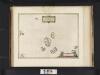
Insulae quaedam minores ex Aebudis quae Mulam et Skiam insulas interjacent. Some of the Smaller Westerne Yles, lying betweene the yles of Mule and Skye / Timotheo Pont auctor.
Pont, Timothy, 1560?-1614? Blaeu, Joan, 1596-1673
Barra - OS One-Inch Map
1 : 63360 Topographic maps Ordnance Survey Ordnance Survey
Rhum and Part of Skye - OS One-Inch Map
1 : 63360 Topographic maps Ordnance Survey Ordnance Survey
Colonsay - Bartholomew's 'Survey Atlas of Scotland'
1 : 126720 Topographic maps John Bartholomew & Son, Ltd John Bartholomew & Son, Ltd
Barra & Mingulay (33) - OS One-Inch map
1 : 63360 Topographic maps Ordnance Survey Ordnance Survey
Barra & Mingulay (33) - OS One-Inch map
1 : 63360 Topographic maps Ordnance Survey Ordnance Survey
The Cuillins, Rhum & Canna (34) - OS One-Inch map
1 : 63360 Topographic maps Ordnance Survey Ordnance Survey
The Cuillins, Rhum & Canna (34) - OS One-Inch map
1 : 63360 Topographic maps Ordnance Survey Ordnance Survey
Coll & Tiree (52) - OS One-Inch map
1 : 63360 Topographic maps Ordnance Survey Ordnance Survey
Coll & Tiree (52) - OS One-Inch map
1 : 63360 Topographic maps Ordnance Survey Ordnance Survey
Lochboisdale & Eriskay (32) - OS One-Inch map
1 : 63360 Topographic maps Ordnance Survey Ordnance Survey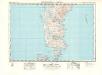
Lochboisdale & Eriskay (32) - OS One-Inch map
1 : 63360 Topographic maps Ordnance Survey Ordnance Survey
North and South Uist - Bartholomew's 'Survey Atlas of Scotland'
1 : 126720 Topographic maps John Bartholomew & Son, Ltd John Bartholomew & Son, Ltd


