Maps of Highland

Le royavme d'Escosse
1 Karte : Kupferdruck ; 45 x 59 cm Nolin; Du Tralage; Coronelli; Mondhare; Jean chez Mondhare et Jean rue St. Jean de Beauvais
Royaume d'Escosse
1 Karte : Kupferdruck ; 37 x 51 cm Fer chez l'autheur dans l'isle du Palais sur le quay de l'Orloge a la sphere royale
Le royavme d'Escosse
1 Karte : Kupferdruck ; 45 x 60 cm Nolin; Coronelli chez I. B. Nolin sur le quay de l'Horloge du Palais proche la rue de Harlay a l'enseigne de la place des Victoires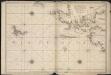
Carte de la mer d'Ecosse contenant les isles et costes septentrionales et occidentales d'Ecosse et les costes septentrionales d'Irlande
1 : 1200000
Das Königreich Scotland
1 Karte : Kupferdruck ; 20 x 27 cm Reilly F. J. J. von Reilly
Karte von Scotland
1 Karte : Kupferdruck ; 54 x 50 cm Schrämbl; Dorret; Stenger zu finden in eigenem Verlage Schrämbl
L'Escosse royaume
1 Karte : Kupferdruck ; 39 x 49 cm Sanson; Fortin chez Fortin ing.r mécanicien du roi pour les globes rue de la Harpe près celle du Foin
A new [and] accurate map of Scotland or North Britain
1 Karte : Kupferdruck ; 41 x 34 cm Bowen s.n.
A correct map of Scotland from new surveys
1 Karte auf 2 Blättern : Kupferdruck ; 75 x 59 cm Dorret s.n.
L'Escosse royaume
1 Karte : Kupferdruck ; 39 x 50 cm Sanson; Mariette chez Pierre Mariette rue St. Iacques a l'esperance
Scotia regnvm cum insulis adjacentibus
2 Karten auf einem Blatt : Kupferdruck ; zusammen 40 x 52 cm Gordon; Blaeu Joan Blaeu
Composite: Scotland.
1 : 633600 Johnston, Alexander Keith, 1804-1871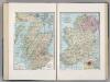
Scotland. Ireland.
1 : 1387366 Hammond, C.S.
Charte von Scotland
1 Karte : Kupferdruck ; 44 x 52 cm Stieler im Verlage des Geographischen Instituts
Scotland.
1 : 1500000 Colton, G.W.
Andrews's new and accurate travelling map of the roads of Scotland, shewing the distances between the towns &c.
1 : 1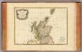
Ecosse.
1 : 2400000 Bonne, Rigobert, 1727-1794
Charte von Schottland
Skotsko Streit, Friedrich Wilhelm
Carte du royaume d'Ecosse
1 Karte : Kupferdruck ; 75 x 51 cm Hérisson; Basset; Perrier; Dien; Basset chez Basset rue Jacques no. 670 au coin de celle des Mathurins
North Britain or Scotland divided into its counties
1 : 800000 Skotsko Kitchin, Thomas Faden, William Wm. Faden
Composite: Scotland.
1 : 486830 Stanford, Edward
Schotland.
1 : 1550000 Radefeld, Carl Christian Franz, 1788-1874
Scotland.
1 : 2100000 Darton, William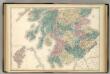
Scotland.
1 : 610000 Hughes, William
Composite: Scotland.
1 : 500000 Cary, John, ca. 1754-1835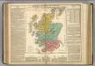
Scotland.
1 : 1550000 Lavoisne, M.
Isles britanniques
1 Karte : Kupferdruck ; 31 x 42 cm Mentelle; Tardieu; André Mentelle
Karte von Scotland
1 : 900000 Skotsko Dorret, J. Schraembl, Franz Anton F.A. Schraembl
Karte von Scotland
1 : 900000 Skotsko Dorret, J. Schraembl, Franz Anton F.A. Schraembl


