Maps of Grampian Mountains

L'Escosse deçà le Tay
1 Karte : Kupferdruck ; 39 x 52 cm Sanson; Fortin; Gordon; Pont chez Fortin ing.r mecanicien du roi p.r les globes rue de la Harpe pres celle du Foin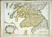
L'Escosse deçà le Tay
1 Karte : Kupferdruck ; 39 x 53 cm Sanson; Gordon; Pont chez l'autheur
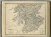
Scotland.
1 : 1170000 Society for the Diffusion of Useful Knowledge (Great Britain)
Scotland.
1 : 1520640 Burr, David H., 1803-1875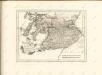
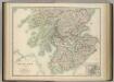
Scotland (southern sheet).
1 : 633600 Johnston, W. & A.K.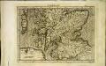
[Südschottland]
1 Karte : Kupferdruck ; 17 x 23 cm Mercator Cloppenburgh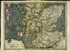
[Südschottland]
1 Karte : Kupferdruck ; 33 x 44 cm Mercator; Hondius Henricus Hondius
[Südschottland]
1 Karte : Kupferdruck ; 33 x 44 cm Mercator; Hondius Jodocus Hondius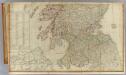
Scotland (south)
1 : 450000 Campbell, Robert, Lieutenant; Kitchin, Thomas; Robert Laurie & James Whittle
[Scotia] [Karte], in: Atlas, sive, Cosmographicae meditationes de fabrica mundi et fabricati figura, S. 89.
1 Karte aus Atlas Mercator, Gerhard
Scotland.
1 : 1760000 Finley, Anthony
[Scotia] [Karte], in: Gerardi Mercatoris Atlas, sive, Cosmographicae meditationes de fabrica mundi et fabricati figura, S. 103.
1 Karte aus Atlas Mercator, Gerhard Montanus, Petrus
Scotland.
1 : 1500000 Colton, G.W.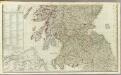
A new and correct map of Scotland or North Britain (Southern section)
1 : 447000 Campbell, Robert, Lieutenant
A map of Scotland
1 : 1250000 Skotsko Virtue, George Starling, Thomas George Virtue
[Kaart], uit: Scotland / The London Geographical Institute
1 : 570000 Annotatie: Reeksvariant vermeld als: Philip's new series of imperial maps for tourists & travellers; Annotatie geografische gegevens: Inzet: Shetland Island; Edinburgh & vicinity The London Geographical Institute, London [London : George Philip & Son]
[Scotiae regnum] or Seconde table d'Escosse
1 : 1100000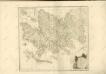

Scotland.
1 : 800000 Thomson, John
Naturalist's map of Scotland
1 : 633600 Harvie-Brown, John Alexander ; Bartholomew, John [John Bartholomew]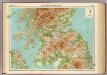
Scotland - southern section.
1 : 633600 John Bartholomew & Co.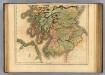
Scotland southern.
1 : 700000 Lizars, Daniel
Scotland.
1 : 775000 Arrowsmith, John
Partie méridionale de l'Ecosse
1 Karte : Kupferdruck ; 49 x 83 cm s.n.
[Kaart], uit: Bartholomew's general map of Scotland
1 : 633600 Edinburgh : Bartholomew [etc.]
Scotland.
1 : 1800000 Tanner, Henry S.

SCOTIA | REGNVM | cum insulis adjacentibus. | Robertus Gordonius a Straloch descripsit.
Auct. Tim. Pont. Io. Blaeu Excudit