Maps of Carmarthenshire

Penbrochia comitatus et comitatus Caermaridvnvm
1 Karte : Kupferdruck ; 39 x 51 cm Blaeu Joan Blaeu
Penbrochia Comitatus et Comitatus Caermardinum
1 : 230000 Amstelodami : apud Joannem Janssonium
PENBROCHIA | Comitatus et Comitatus | CAERMARIDVNVM.
[Amsterdam : Joan Blaeu]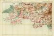
South Wales and the border in the 14th century
Rees, William Ordnance Survey
PENBROK comitat
This map of Penbrokeshire is from the 1583 edition of the Saxton atlas of England and Wales.This atlas was first published as a whole in 1579. It consists of 35 coloured maps depicting the counties of England and Wales. The atlas is of great significance to British cartography as it set a standard of cartographic representation in Britain and the maps remained the basis for English county mapping, with few exceptions, until after 1750. During the reign of Elizabeth I map use became more common, with many government matters referring to increasingly accurate maps with consistent scales and symbols, made possible by advances in surveying techniques. Illustrating the increasing used of maps in government matters, Lord Burghley, Elizabeth I’s Secretary of State, who had been determined to have England and Wales mapped in detail from the 1550s, selected the cartographer Christopher Saxton to produce a detailed and consistent survey of the country. The financier of the project was Thomas Seckford Master of Requests at the Court of Elizabeth I, whose arms appear, along with the royal crest, on each map. Saxton, Christopher Ryther, Augustine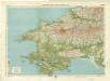
Pembroke, Sheet 21 - Bartholomew's "Half Inch to the Mile Maps" of England & Wales
1 : 126720 Topographic maps Bartholomew, John George John Bartholomew & Co
PENBROK Comitat.
This is a map of Pembrokeshire by Christopher Saxton dating from 1578. It forms part of an atlas that belonged to William Cecil Lord Burghley, Elizabeth I’s Secretary of State. Burghley used this atlas to illustrate domestic matters. This map is actually a proof copy of one which forms part of Christopher Saxton’s Atlas of England and Wales. This atlas was first published as a whole in 1579. It consists of 35 coloured maps depicting the counties of England and Wales. The atlas is of great significance to British cartography as it set a standard of cartographic representation in Britain and the maps remained the basis for English county mapping, with few exceptions, until after 1750. During the reign of Elizabeth I, map use became more common, with many government matters referring to increasingly accurate maps with consistent scales and symbols, made possible by advances in surveying techniques. Illustrating the increasing use of maps in government matters, Lord Burghley, who had been determined to have England and Wales mapped in detail from the 1550s, selected the cartographer Christopher Saxton to produce a detailed and consistent survey of the country. The financier of the project was Thomas Seckford, Master of Requests at the Court of Elizabeth I, whose arms appear, along with the royal crest, on each map. Burghley has annotated this map, adding place names and a dotted line marking the route from Manernowen on the coast to Cardigan. At this time England was under threat of invasion from Catholic Spain, a threat which culminated in the events of the Spanish Armada. Defence of the realm depended on a good geographic and topographic knowledge, explaining Burghley's use of maps and his annotation of them, particularly at coastal locations. The map was engraved by one of a team of seven English and Flemish engravers employed to produce the copper plates for the atlas, although the individual engraver is not noted. Saxton, Christopher William Cecil, Lord Burghley
Fishguard - OS One-Inch Map
1 : 63360 Topographic maps Ordnance Survey Ordnance Survey
Pembroke - OS One-Inch Map
1 : 63360 Topographic maps Ordnance Survey Ordnance Survey
Cardigan - OS One-Inch Map
1 : 63360 Topographic maps Ordnance Survey Ordnance Survey
Carnarthen And Tenby - OS One-Inch Map
1 : 63360 Topographic maps Ordnance Survey Ordnance Survey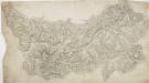
Newcastle-in-Emlyn
1 : 31680 This plan of North Carmarthenshire shows the Teify Valley at the top, with settlements, enclosed farmland and densely wooded areas dominating the valley landscape. Mynydd Llanllwni and Pencarreg depicted at the bottom of the sheet form the valley's distinctive backdrop. Rising steeply from the valley, the rounded and open plateau summit of Mynydd Llanllwni contains extensive areas of moorland and common land, represented by open dots on the plan. Budgen, Thomas
Llandovery(002OSD000000021U00146000)
1 : 31680 Towy Valley, the major historic route into west Wales, is depicted at the top of the plan, with a section of the ancient Roman road from Llandovery to Landilo Fawr. Near the bottom of the sheet, dense brushwork is used to describe the peaks of the Black Mountains. Budgen, Thomas
Haverfordwest
1 : 31680 This plan of the north Pembrokeshire coast and St David's Peninsula shows the low, gentle hills that characterise the peninsular landscape. The coast is illustrated with pointed rocks below the cliffs. Aber-Eiddy, indicated near the top margin of the sheet, is the only landing place along this stretch of a coastline battered by rough tides and strong winds. To the left of the sheet is the city of St David's. Named after the patron saint of Wales, it was a place of Christian pilgrimage during the Middle Ages. Two journeys to St David's equalled one journey to Rome, and hundreds of British pilgrims flocked each year to the shrine at St David's Cathedral. Budgen, Tomas
Tenby
1 : 31680 This plan of the Pembrokeshire coast shows the deep-sea port of Tenby at lower right and the River Cleddau Valley, with its broad tidal estuary flowing into Milford Haven, at lower left. Tidal rivers, called 'pills' on this plan, are a peculiar feature of the south Pembrokeshire landscape. Along the banks of one of the pills is the small settlement of Carew with the remains of an 11th-century castle and tidal mill indicated. Budgen, Thomas
Cardigan
1 : 31680 This plan of part of Cardiganshire shows the county town on the,north bank of the,River Teify as it,enters Cardigan,Bay. Further inland, the landscape is dominated by moorland and the peaks of the Presely Mountains, represented by dense brushwork interlining ('hachuring'). The huge blue stones,that make up,the ancient ceremonial site of Stonehenge came from these mountains -,a journey of some 200 miles. Budgen, Thomas
Llanon
1 : 31680 Widely dispersed farms form the prevailing settlement pattern of this part of South Carmarthenshire. Shown near the top are Towy Valley, the major historic route into west Wales, and the Roman road from Carmarthen to Llandovery. Llanon is depicted near the centre along the tollroad from Llanelly. Situated on the north bank of the River Burry, Llanelly was a small parish town at the time of the Ordnance Survey. Sand dunes and marshland dominate the landscape of The Burry inlet at the bottom of the sheet. Budgen, Thomas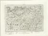
Cardigan (Outline) - OS One-Inch Revised New Series
1 : 63360 Topographic maps Ordnance Survey Ordnance Survey
Cardigan (Hills) - OS One-Inch Revised New Series
1 : 63360 Topographic maps Ordnance Survey Ordnance Survey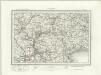
Haverfordwest (Outline) - OS One-Inch Revised New Series
1 : 63360 Topographic maps Ordnance Survey Ordnance Survey
Haverfordwest (Hills) - OS One-Inch Revised New Series
1 : 63360 Topographic maps Ordnance Survey Ordnance Survey
Newcastle Emlyn (Hills) - OS One-Inch Revised New Series
1 : 63360 Topographic maps Ordnance Survey Ordnance Survey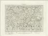
Newcastle Emlyn (Outline) - OS One-Inch Revised New Series
1 : 63360 Topographic maps Ordnance Survey Ordnance Survey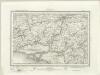
Carmarthen (Outline) - OS One-Inch Revised New Series
1 : 63360 Topographic maps Ordnance Survey Ordnance Survey
Carmarthen (Hills) - OS One-Inch Revised New Series
1 : 63360 Topographic maps Ordnance Survey Ordnance Survey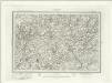
Llandovery (Outline) - OS One-Inch Revised New Series
1 : 63360 Topographic maps Ordnance Survey Ordnance Survey
Llandovery (Hills) - OS One-Inch Revised New Series
1 : 63360 Topographic maps Ordnance Survey Ordnance Survey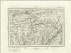
Ammanford (Outline) - OS One-Inch Revised New Series
1 : 63360 Topographic maps Ordnance Survey Ordnance Survey
Ammanford (Hills) - OS One-Inch Revised New Series
1 : 63360 Topographic maps Ordnance Survey Ordnance Survey


