Maps of Hertfordshire

A new improved map of Hartford Shire
1 Karte : Kupferdruck ; 51 x 64 cm Kitchin; Hinton; Walker sold by I. Hinton at the Kings Arms in St. Pauls Church yard
HARTFORDIAE COMITATUS f.34
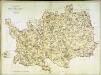
This is a map of Herefordshire by Christopher Saxton which dates from 1577. It forms part of an atlas that belonged to William Cecil Lord Burghley, Elizabeth I’s Secretary of State. Burghley used this atlas to illustrate domestic matters. This map is actually a proof copy of one which forms part of Christopher Saxton’s Atlas of England and Wales. This atlas was first published as a whole in 1579. It consists of 35 coloured maps depicting the counties of England and Wales. The atlas is of great significance to British cartography as it set a standard of cartographic representation in Britain and the maps remained the basis for English county mapping, with few exceptions, until after 1750. During the reign of Elizabeth I, map use became more common, with many government matters referring to increasingly accurate maps with consistent scales and symbols, made possible by advances in surveying techniques. Illustrating the increasing use of maps in government matters, Lord Burghley, who had been determined to have England and Wales mapped in detail from the 1550s, selected the cartographer Christopher Saxton to produce a detailed and consistent survey of the country. The financier of the project was Thomas Seckford Master of Requests at the Court of Elizabeth I, whose arms appear, along with the royal crest, on each map. Lord Burghley has added several place names to the map. This map was engraved by Nicholaus Reynoldus one of a team of seven English and Flemish engravers employed to produced the copper plates for the atlas. Saxton, Christopher Reynoldus, Nicholaus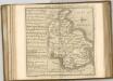
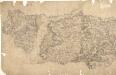
A topographical map of Hartford-Shire
1 Karte : Kupferdruck ; 52 x 70 cm Dury; Andrews Andrew Dury
HARTFORDIAE COMITATUS Sheet 13
This map of Hertfordshire is from the 1583 edition of the Saxton atlas of England and Wales. This atlas was first published as a whole in 1579. It consists of 35 coloured maps depicting the counties of England and Wales. The atlas is of great significance to British cartography as it set a standard of cartographic representation in Britain and the maps remained the basis for English county mapping, with few exceptions, until after 1750. During the reign of Elizabeth I map use became more common, with many government matters referring to increasingly accurate maps with consistent scales and symbols, made possible by advances in surveying techniques. Illustrating the increasing used of maps in government matters, Lord Burghley, Elizabeth I’s Secretary of State, who had been determined to have England and Wales mapped in detail from the 1550s, selected the cartographer Christopher Saxton to produce a detailed and consistent survey of the country. The financier of the project was Thomas Seckford Master of Requests at the Court of Elizabeth I, whose arms appear, along with the royal crest, on each map. A decorative scale bar houses Saxton’s name and the name of the engraver Remigius Hogenberg, one of seven English and Flemish engravers employed to produce the copper plates for the atlas. Relief, in the form of uniform rounded representations of hills, is the main topographical feature presented in the maps. Rather than provide a scientific representation of relative relief these give a general impression of the lie of the land. Settlements and notable buildings are also recorded pictorially; a small building with a spire represents a village, while more important towns, such as Hereford are indicated by groups of buildings. Saxton, Christopher Ryther, Augustine
HERTFORDIA | COMITATVS. | Vernacule | HERTFORDSHIRE.
[Amsterdam : Joan Blaeu]
Hertfordia comitatvs vernacule Hertfordshire
1 Karte : Kupferdruck ; 37 x 48 cm Blaeu Joan Blaeu
Middelsexiæ cum Hertfordiæ comitatu
1 Karte : Kupferdruck ; 42 x 52 cm Valck; Schenk apud G. Valk et P. Schenk
Hertfordia Comitatus. Vernacule Hertfordshire [Karte], in: Theatrum orbis terrarum, sive, Atlas novus, Bd. 4, S. 254.
1 Karte aus Atlas Blaeu, Joan Blaeu, Willem Janszoon
Herfordia Comitatus. Vernacule Hertfordshire [Karte], in: Le théâtre du monde, ou, Nouvel atlas contenant les chartes et descriptions de tous les païs de la terre, Bd. 4, S. 226.
1 Karte aus Atlas Blaeu, Willem Janszoon und Blaeu, Joan Blaeu, Willem Janszoon
Hertfordia Comitatus. Vernacule Hertfordshire [Karte], in: Theatrum orbis terrarum, sive, Atlas novus, Bd. 4, S. 254.
1 Karte aus Atlas Blaeu, Joan Blaeu, Willem Janszoon
Middelsexiae cum Hertfordiae Comitatu = Midlesex & Hertford Shire
1 : 160000 Amstelodami : apud Joannem Janssonium
Bedford and Luton - OS One-Inch Map
1 : 63360 Topographic maps Ordnance Survey Ordnance Survey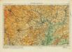
Hertford& St Albans
Ordnance Survey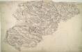
Luton
The boundaries of the counties of Bedfordshire, Buckinghamshire, and Hertfordshire are marked on this plan by pecked red lines. Red dots within circles indicate trigonometrical points from which the surveyor took angular measurements to plot topographical features of the landscape. Hyett, William
London passenger transport map
Ordnance Survey
The county of Bedford
1 Karte : Kupferdruck ; 68 x 45 cm Jefferys s.n.
An accurate map of the county of Bedford
1 Karte : Kupferdruck ; 68 x 50 cm Bowen; Hinton sold by I Hinton at the Kings Arms in St. Pauls Church Yard
London passenger transport map
Ordnance Survey
England and Wales [OS of]
Ordnance Survey
Hemel Hempstead
1 : 31680 This drawing describes a section of the Grand Junction Canal. The prehistoric Icknield Way appears at the top left of the plan. Hill-shading techniques and the attention given to communications routes conform to the military and cartographic standards employed by the Survey. Some name corrections are visible in faded ink in the centre of the map around Bovingdon. Harefield Common is also revised. Hyett, William
Hatfield
1 : 31680 This map is not drawn with north at the top. Potters Bar appears at the bottom left, almost on a level with Hertford at the bottom right. The remains of the Old Royal Palace of Hatfield are shown near the centre of the map. This was the home of Elizabeth I (1533-1603) prior to her accession to the throne. Also featured is Hatfield, the house built in 1611 by the first Earl of Salisbury, Robert Cecil (1563-1612). A poorhouse is marked just outside the town. Hyett, William
Hitchin (Hills) - OS One-Inch Revised New Series
1 : 63360 Topographic maps Ordnance Survey Ordnance Survey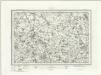
Hitchin (Outline) - OS One-Inch Revised New Series
1 : 63360 Topographic maps Ordnance Survey Ordnance Survey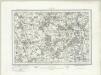
Hertford (Outline) - OS One-Inch Revised New Series
1 : 63360 Topographic maps Ordnance Survey Ordnance Survey
Hertford (Hills) - OS One-Inch Revised New Series
1 : 63360 Topographic maps Ordnance Survey Ordnance Survey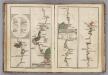
Watford to Rickmans Worth to Amersham, Watford to St. Albans.
1 : 63360 Cary, John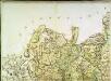
A topographical map of Hartford-Shire, 2
1 Blatt : 53 x 72 cm A. Dury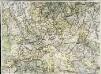
A topographical map of Hartford-Shire, 5
1 Blatt : 53 x 72 cm A. Dury