Maps of Mediterranean Sea
Theatre de la guerre entre les Russiens et les Turcs
1 Karte auf 2 Blatt : Kupferdruck ; 50 x 93 cm Roth C. M. Roth
Karte der griechischen Welt
Evropa jižní F. Tempsky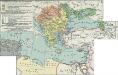
II. Rückgang des Osmanischen Reichs (Orientalische Frage) seit 1683
1 : 28000000 Osmanisches Reich
Di-gyiu Du, Ng Da-tsiu Di-du[地舆图、五大洲地图]
Di-gyiu Du, Ng Da-tsiu Di-du[地舆图、五大洲地图] 1853年,Martin, W. A. P. (William Alexander Parsons) 美国长老会传教士丁韪良用罗马拼音标注宁波方言编写的世界地理著作,对地球和各大洲进行介绍。内有东西半球图、亚洲图、欧洲图、非洲图、北美洲图、南美洲图、地中海附近图、清内地十八省图、浙江省图、宁波附近图等。 10图,墨刻本,罗马拼音标注宁波方言,图幅不一,约39 x 49.5 cm Harvard-Yenching | Rare Book | TA 2370 92,Hollis Number:008156153
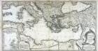
Generalkarte der Mittelmeerländer
Mare internum cum populis adiacentibus a Pompeii ex Asia reditu usque ad bellum Actiacum.
1 : 12000000 Menke, Th.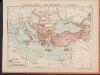
L'Empire Grec au Commencement du IX.e siècle
Byzantinisches Reich Kümmerly & Frey
M. Herberers ongelukkige voyagie gedaan in verscheyde gedeeltens van Asia en Africa
1 : 24000000 1 Karte : Kupferdruck ; 22 x 29 cm Aa, Pieter van der [Michel Herberer]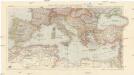
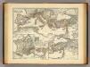
Karte der Länder des Mittelmeeres
1 : 5000000 Středozemní moře-oblast Freytag & Berndt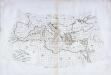
Carte des pays qu'occupe maintenant la mer Mediterranée
1 Karte : Kupferdruck ; 32 x 66 cm La Borde s.n.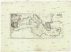
Karte des Mittellaendischen Meers
Středozemní moře-oblast Bonne, Rigobert Schraembl, Franz Anton F.A. Schraembl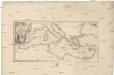
Karte des Mittellaendischen Meers
Středozemní moře-oblast Bonne, Rigobert Schraembl, Franz Anton F.A. Schraembl
Itinera expeditionum sacrarum
Europa, Mittelmeerraum, Reiseweg
Geographie des Grecs Primitive.
Malte-Brun, Conrad, 1775-1826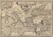
Argonautica. [Karte] [Europa.], [Thessalia und Umgebung], [Hellespontus, Phryxeum aequor, et Athamantidis fluenta.] [3 Nebenkarten], in: Theatrum orbis terrarum, S. 538.
1 Karte aus Atlas Ortelius, Abraham Vrients, Jan Baptista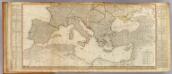
Europe (south)
1 : 4800000 Anville, Jean Baptiste Bourguignon d, 1697-1782; Kitchin, Thomas; Robert Laurie & James Whittle
Carte nouvelle de la mer Mediterranée : divisée en mer de Levant et de Ponant, subdivisés en leurs principales parties ou mers : avec les observations des Mrs. de l'Académie
1 : 4375000 Sanson, Nicolas, 1600-1667 chez Pierre Mortier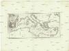
Karte des Mittellaendischen Meers
Středozemní moře Bonne, Rigobert Schraembl, Franz Anton F.A. Schraembl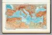
101. Mediterranean Sea. The World Atlas.
1 : 10000000 USSR (Union of Soviet Socialist Republics).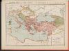
L'Empire Grec à la mort de Basile le Bulgarochtone et sous ses Héritiers
Byzantinisches Reich Basileios II.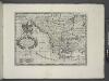
A new map of Turky in Europe and parts adjoyning shewing their principal divisions and chief cities, towns, rivers, mountains &c.
from A new sett of maps both of antient and present geography : wherein not only the latitude and longitude of many places are corrected according to the latest observations, but also the most remarkable differences of antient and present geography may be quickly discern'd by a bare inspection or comparing of correspondent maps, which seems to be the most natural and easy method to lead young students (for whose use the work is principally intended) unto a competent knowledge of the geographical science : together with a geographical treatise particularly adapted to the use and design of these maps / by Edward Wells, M.A. and student of Christ-Church, Oxon.
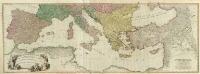
Map of the Austrian Empire, Italian States, Turkey in Europe, and Greece ; Maltese Islands [inset]
from New general atlas.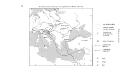
Geschäftsverbindungen und Kupferhandel der Medici 1393-1395
Europa Medici, Bankiers, Fuersten, Italien
De landen van 't Romeinsche gebied in welke de Christen kerk, kort na Christus hemelvaard, door den dienst der apostelen is uitgebreid : tot verklaringe van de Handelingen der Apostelen
1 : 6500000 afgebeeld door W.A. Bachiene J. van Jagen mapp. sculpsit, et figur. apposit sculpturam curavit ; S. Fokke fecit. Uitgegeven te Gorinchem : by Nicolaas Goetzee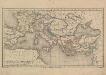
Europa und das oström. Reich zur Zeit der Kreuzzüge
Europa, Byzantinisches Reich, Kreuzzüge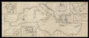
A correct chart of the Mediterranean sea from the coast of Portugal to the Levant
6 Carta nàutica. Conté: A plan of the city and Port of Civita-Vechia; The bay of Scanderoon; The bay of Tunis; A plan of the port of Neptune or Nation. Datació aproximada. Mount & Page William Mount & Thomas Page
Mittelländisches und Schwarzes Meer
Atlas der Hydrographie Berghaus, Hermann Justus Perthes
Orbis Homeri. 900? Ante Chr.
Mittelmeerraum Homerus
Turkey, in Europe and Hungary, from the best authorities.
from Carey's general atlas, improved and enlarged : being a collection of maps of the world and quarters, their principal empires, kingdoms, &c.