Maps of Ontario
Océan atlantique et mers adjacentes, 1
2 Blätter : 48 x 135 cm Le Rouge
General Charte von Russischen Reiche in Europa, Asien und America
1 : 14200000 Rusko Weiland, Karl Ferdinand Geographisches Institut
Map of part of the United States of North America : with the territory of the Illinois on the Ohio, particularly designed to illustrate Birkbeck's journey / Neele & Son, sc., 352 Strand.
from Parts
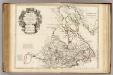
Le Canada Ou Partie Dela Nouvelle France. Contenant La Terre De Labrador La Nouvelle France, Les Isles De Terre Neuve, de Nostredame &c: [Karte], in: Atlas nouveau, contenant toutes les parties du monde [...], Bd. 2, S. 250.
1 Karte aus Atlas Sanson, Nicolas Jaillot, Alexis Hubert und Mortier, Pieter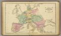
Continental Europe.
1 : 9000000 Cornell, S. S. (Sarah S.)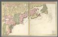
Nova tabula geographica complectens borealiorem Americae partem.
from Charts and maps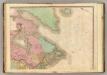
North America, N.E.. Sheet.
1 : 7600000 Tanner, Henry S.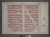
Plate 4: Part of Section 7.
from Atlas of the city of New York, borough of Manhattan / from actual surveys and official plans by George W. and Walter S. Bromley.
Mappa geographica Americae Septentrionalis : ad emendatiora exemplaria adhuc edita jussu Acad. reg. scient. et eleg. litt. descripta.
from Charts and maps
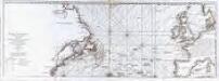
The Western Ocean.
from Charts and maps Jeremiah Seller & Charles Price?: [London?],
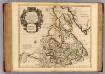
Partie orientale du Canada ou de la Nouvelle France : ou sont les provinces, ou pays de Sagvenay, Canada, Acadie etc., les peuples, ou nations des Etechemins, Iroquois, Attiquameches etc., auec la Nouvelle Angleterre, la Nouvelle Ecosse, la Nouvelle Yorc
from Canada
Tierra nveva.
from Charts and maps Sesssa?: [Venice]; Ruscelli, Girolamo; Gastaldi, Giacomo,
North America from the French of Mr. D'Anville : improved with the back settlements of Virginia and course of Ohio : illustrated with geographical and historical remarks.
from A summary, historical and political, of the first planting, progressive improvements, and present state of the British settlements in North-America ... By William Douglass, M.D. ... Boston, New-England, Printed:

British Provinces of North America.
1 : 10000000 Cornell, S. S. (Sarah S.)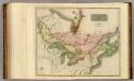
Canada, Nova Scotia.
1 : 4800000 Thomson, John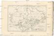
Canada
1 : 10120000 Kanada Bonne, Rigobert André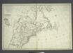
Carte nouvelle de l'Amerique angloise: contenant la Virginie, Mary-Land, Caroline, Pensylvania, Nouvelle Iorck, N. Iarsey, N. France, et les terres nouvellement decouerte dressé sur les relations les plus nouvelles / par le Sieur S.
from John H. Levine Collection le Sieur S.,
Le Canada, ou Nouvelle France, &c. : tireé de diverses relations des Francois, Anglois, Hollandois, &c. / par N. Sanson d'Abb'. geogr. ordre. du Roy ; A.d. Winter schulp.
from Charts and maps
New Map of Upper & Lower Canada.
1 : 130000000 Morse, Jedidiah
Nova tabula geographica complectens borealiorem Americae partem : in qua exacte delineatae sunt Canada sive Nova Francia, Nova Scotia, Nova Anglia, Novum Belgium, Pensylvania, Virginia, Carolina et Terra Nova : cum omnibus littorum pulvinorumque profundi
from John H. Levine Collection
EXTREMA AMERICÆ | Versus Boream, ubi | TERRA NOVA | NOVA FRANCIA, Adjacentiaq.
Amstelaedami Io. Blaeu Exc.
Map of the Northern and Middle States.
1 : 6900000 Morse, Jedidiah
Map of the Northern and Middle States.
1 : 6950000 Morse, Jedidiah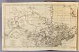
Canada, N. pt. Louisiana.
1 : 7700000 Jefferys, Thomas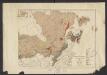
Geology. East sheet
1 : 6336000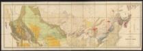
Map of the Dominion of Canada
1 : 2700000 Geological and Natural History Survey (Canada) Geological and Natural History Survey of Canada
A map of the northern and middle states
Canada, Nouvelle France.
1 : 9000000 L'Isle, Guillaume de, 1675-1726