Maps of United States

Pascaart vertoonende de zeecusten van Chili, Peru, Hispania Nova, Nova Granada, en California
1 Karte : Kupferdruck ; 43 x 55 cm Doncker by Hendrick Doncker boeckverkooper in de Nieuwe brugh steegh in 't Stuiermans gereedtschap
Points de partage et Communications projettees.
Humboldt, Alexander von, 1769-1859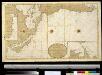
Nieuwe afteekening van de de Zuijdt Zee van C. de Hoorn tot California als ook het Compagnies Landt ent Land van Eza
America Gerard van Keulen
Mexico, or, New Spain : divided into the audiance of Guadalayara, Mexico, and Guatimala, Florida.
from System of geography with new maps
New Spain ; Guiana.
from A new systeme of the mathematicks: containing I. Arithmetick, as well natural and decimal, as in species, or the principles of algebra. II. Practical geometry, together with the first six books of Euclid's Elements, as also the eleventh and twelfth, symbo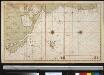
De Grote Oceaan
Pacific Ocean Gerard van Keulen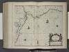
Pascaerte van Nova Hispania, Chili, Peru, en Gvatimala.
from De zee-atlas ofte water-wereld : waer in vertoont werden alle de zee-kusten van het bekende des aerd-bodems : seer dienstigh voor alle heeren en kooplieden, als oock voor alle schippers en stuurlieden / by Pieter Goos.
Stromgebiet von Nordamerica
Grosser Hand-Atlas über alle Theile der Erde in 170 Karten Meyer, J. Verlag des Bibliographischen Instituts
Messico, ouvero Nuova-Spagna : che contiene il Nuovo Messico, la California con una parte de paesi adjacenti / G. Pitteri scr.
from Mexico
Pascaerte van Westindien : de vaste kusten en de Eylanden.
from De zee-atlas, ofte, Water-weereld : waer in vertoont werden alle de zee-kusten van het bekende des aerd-bodems : seer dienstigh voor alle heeren en kooplieden, als oock voor alle schippers en stuurlieden / gesneden, gedruckt en uytgegeven t'Amsteldam.
Ornamental map of the United States & Mexico / Barritt sc.
from Parts
Map of the United States and Mexico
1 : 6000000 Johnson & Browning
Republics Of North America
1 : 3041280 Colton, J. H.
New Map Of The Union.
1 : 6000000 Johnson, D. Griffing
Map of the country between Washington & Pittsburg refering to the contemplated Chesapeake & Ohio Canal and its general route and profile, October 1826 / reduced from the general map annexed to the report upon the comtemplated canal & drawn, b
from Parts
A new and correct map of North America with the West India Islands : divided according to the last treaty of peace, concluded at Paris, 10th Feby. 1763 ; wherein are particularly distinguished, the several provinces and colonies, which compose the Britis
from Whole
Johnson's new illustrated & embellished county map of the republics of North America : with the adjacent islands & countries / compiled, drawn & engraved from U. States land & coast surveys, British Admiralty & other reliable sources by D. Griffing Johns
from Parts
America septentrionalis
1 Karte : Kupferdruck ; 45 x 53 cm Janssonius excudit Ioannes Janssonius
America septentrionalis
1 Karte : Kupferdruck ; 45 x 53 cm Valck; Schenk penes Gerardum Valk et Petrum Schenk
A new mapp of the Empire of Mexico describing the continent to the Istmus of Panama : together with all the islands in the North Sea / F. Lamb sculp.
from Charts and maps
Map of the United States of America, the British provinces, Mexico, the West Indies and Central America, with part of New Granada and Venezuela / map drawn by Geo. W. Colton; engraved by John M. Atwood; border desig'd. & eng'd. by W.S. Barnard.
from Parts George W. Colton; John M. Atwood; W. S. Barnard,
Regni Mexicani seu Novae Hispaniae, Floridae, Novae Angliae, Carolinae, Virginiae et Pensylvaniae necnon insularum archipelagi Mexicani in America Septentrionali
from Charts and maps
America Septentrionalis. [Karte], in: Novus atlas absolutissimus, Bd. 6, S. 197.
1 Karte aus Atlas Janssonius Offizin
Map Of The United States, Canada, Mexico, Central America, and the West India Islands.
1 : 12500000 Atwood, J.M.
Nord America
Hand-Atlas über alle Theile der Erde nach dem neuesten Zustande und über das Weltgebäude Stieler, Adolf bei Justus Perthes
North America / performed under the patronage of Louis Duke of Orleans, First Prince of the Blood by the Sieur d'Anville ; greatly improved by Mr. Bolton ; engrav,d by R. W. Seale ; Gravelot, delin. ; Walker, sculp.
from Charts and maps
A new map of the north parts of America claimed by France under ye names of Louisiana, Mississipi, Canada and New France, with ye adjoyning territories of England and Spain ... / ... laid down according to the newest and most exact observations by H. Mol
from The world described, or, A new and correct sett of maps : shewing the kingdoms and states in all the known parts of the earth, with the principal cities, and most considerable towns in the world ... / ... by Herman Moll, geographer ...
America Septentrionalis.
from Whole Excudit Ioannes Ianssonius: Amstelodami; Jansson, Jan,
North America / performed under the patronage of Louis Duke of Orleans, First Prince of the Blood by the Sieur d'Anville ; greatly improved by Mr. Bolton ; engrav,d by R. W. Seale ; Gravelot, delin. ; Walker, sculp.
from Whole


