Maps of Indian Ocean

[Indischer Ozean, westlicher Teil]
1 Karte : Kupferdruck ; 57 x 45 cm Doncker Hendrik Doncker
Occidentalior tractus Indiarum Orientalium à promontorio Bonæ Spei ad C. Comorin
1 Karte : Kupferdruck ; 43 x 54 cm Renard à L. Renard
[138][141] Occidentalior Tractus Indiarum Orientalium ..., uit: Atlas sive Descriptio terrarum orbis
Annotatie: Gedigitaliseerde versie. Amsterdam. Heiloo : Picturae (vervaardiger), 2015. tiff-bestand. Gedigitaliseerd: 07-01-2015; Origineel: Universiteitsbibliotheek Vrije Universiteit (XL.05127.-) ; Netherlands; Titelpagina ontbreekt Wit, Frederik de Amsterdam : Frederick de Wit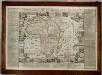
L'Afrique, divisée selon l'etendue de ses principales parties ... / dressée par N. de Fer ; H. van Loon fecit
1 : 12500000 Annotatie: Met afbeeldingen rondom de kaart en: "Description de l'Afrique et des états de l'Afrique Fer, N. de; Loon, Herman van Paris : G. Danet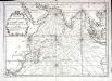
Carte de l'ocean oriental ou mer des Indes
1 Karte : Kupferdruck ; 33 x 47 cm Bellin Arkstée et Merkus
Uebersichts-Karte der ethnographischen Verhältnisse von Asien und von den angrenzenden Theilen Europa'sbearbeitet und herausgegeben mit Unterstützung der kaiserlichen Akademie der Wissenschaften in Wien von Vinzenz v. Haardt
Hartenthurn, Vincenz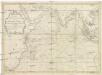
Carte de l'Ocean oriental ou Mer des Indes
1 : 7300000 Indický oceán-oblast Bellin, Jacques-Nicolas
Totius Africae nova repraesentatio, qua praeter diversos in ea status et regiones, etiam origo Nili ex veris rr. pp. missionariorum relationibus ostenditur
1 : 13750000 Homann, Johann Baptist, 1663-1724 s.n.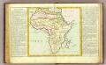
De l'Afrique.
1 : 27000000 Clouet, J. B. L. (Jean-Baptiste Louis), b. 1730
Costa oriental de Africa
1 : 25000000 1 mapa, col. Full d'un atles en llengua castellana no identificat, que conté mapes físics, polítics i sobre el servei de correus. Datat al 1890 aproximadament.
Presbiteri Iohannis, Sive, Abissinorum imperii Descriptio. [Karte], in: Theatrum orbis terrarum, S. 314.
1 Karte aus Atlas Ortelius, Abraham
Presbiteri Iohannis, Sive, Abissinorum imperii Descriptio. [Karte], in: Theatrum orbis terrarum, S. 415.
1 Karte aus Atlas Ortelius, Abraham Vrients, Jan Baptista
Mittel- und Nord-Africa und Arabien. Östliches Blatt
Stieler's Hand-Atlas Stieler, Adolf bei Justus Perthes
[Mittel- und Nord-Africa und Arabien, Oestliches Blatt]
Hand-Atlas über alle Theile der Erde nach dem neuesten Zustande und über das Weltgebäude Stieler, Adolf bei Justus Perthes

Nordost-Afrika und Arabien
Handatlas über alle Theile der Erde und über das Weltgebäude Stieler, Adolf Justus Perthes
[Mittel- und Nord-Africa, Oestl. Theil und Arabien]
Hand-Atlas über alle Theile der Erde und über das Weltgebäude Stieler, Adolf Justus Perthes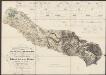
Carte Particuliere De La Mer Rouge &c. Levée Par Ordre Expres des Roys de Portugal sous qui on en a Fait la Decouverte. [Karte], in: Atlas nouveau, contenant toutes les parties du monde [...], Bd. 2, S. 228.
1 Karte aus Atlas Sanson, Nicolas Jaillot, Alexis Hubert und Mortier, Pieter
Sexta Asie Tabula [Karte], in: Claudii Ptolemei viri Alexandrini mathematice discipline philosophi doctissimi geographie opus [...], S. 208.
1 Karte aus Atlas Waldseemüller, Martin [und Ptolemaeus, Claudius] Übelin, Georg
Politische Übersicht von Ostafrika
1 : 8000000 Afrika jižní Kiepert, Heinrich Dietrich Reimer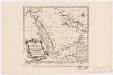
Carte de la coste d'Arabie, Mer Rouge et Golfe de Perse : tirée de la Carte de l'Océan Oriental publiée en 1740 par Ordre de Mgr le Comte de Maurepas augmentée sur des remarques particulières et dressée sur des observations astronomiques = Kaart van de Kust van Arabië, de Roode-Zee en de Gulf van Persië Gemaakt na de Fransse-Kaart van den Ooster-Ocean uitgegeven A. 1740 op Bevel van den Hre Grave de Maurepas Vermeederd op byzondere Aanmerkingen, en geschikt volgens Sterrekundige-Waarnemi
1 : 14000000 Schley, Jacobus van der, 1715-1779 Pierre de Hondt
Sexta Asie Tabula [Karte], in: [Clavdii Ptholomei Cosmographi ...], S. 317.
1 Karte aus Atlas Nicolaus Germanus [und Ptolemaeus, Claudius]
Nordost-Afrika Und Arabien.
1 : 12500000 Petermann, A.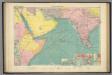
Arabian Sea.
1 : 10000000 Philip, George
Charte der Nordküste Africas, oder die staaten Maroccos, Fes, Algier, Tunis, Tripoli, und Aegypten : nach den neuesten und besten Hülfsmitteln
1 : 5000000 Reinecke, J. C. M. (Johann Christoph Matthias), 1770-1818 Verlage des Landes Indust. Compt.
Africa (Northeast Part). Africa (Central Part).
1 : 12070000 Hammond, C.S.
Tabula Asiae VI. [Karte], in: Claud. Ptolemaeus. Geographia lat. cum mappis [...], S. 311.
1 Karte aus Atlas Münster, Sebastian [und Ptolemaeus, Claudius]
Carte de l'Ethiopie Orientale située sur la Mer des Indes entre la Cap Guardasouin, & le Cap de Bonne Esperance
1 : 8500000 dressée sur les meilleurs memoires principalement sur ceux des Portugais par le Sr. d'Anville [...] aout 1727 Delahaye sculpsit [Paris] : le Sr. d'Anville
Tabula Asiae VI. [Karte], in: Geographia universalis vetus et nova complectens Claudii Ptolemaei Alexandrini enarrationis libros VIII, S. 281.
1 Karte aus Atlas Münster, Sebastian [und Ptolemaeus, Claudius]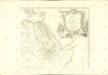
![[Indischer Ozean, westlicher Teil]](http://biblio.unibe.ch/web-apps/maps/zoomify.php?pic=Ryh_1201_27.jpg&col=ryh)

