Maps of Antoing
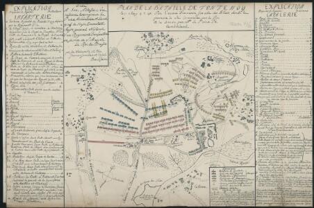
Plan De La Bataille De Fontenoy le 11. May 1745 Par l'armée Francoise sur celle des Allies, dont la premiere à été Comandée par le Roi et la derniere par M. Le Prince de Cumberland
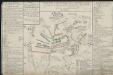
Bataille De Fontenoi Gagnée Par L'Armée Française Sur Celle Des Alliés Le XI. Mai. M.LCC.XLV. [i.e. MDCCXLV]
Ludwig VIIII. (Hessen-Darmstadt, Landgraf)
Plan parcellaire de la commune de Antoing : avec les mutations
1 : 5000 Royal Library of Belgium Map Room Popp, Philippe Christian (1805-1879) Popp, Philippe Christian (1805-1879)
Plan parcellaire de la commune de Vaulx lez-Tournay : avec les mutations
1 : 5000 Royal Library of Belgium Map Room Popp, Philippe Christian (1805-1879) Popp, Philippe Christian (1805-1879)
Plan parcellaire de la commune de Fontenoy : avec les mutations
1 : 5000 Royal Library of Belgium Map Room Popp, Philippe Christian (1805-1879) Popp, Philippe Christian (1805-1879)
Développement du village de Gaurain et des hameaux : Ramecroix, La Crotière et la Louvière à l'échelle d'un à 2500
1 : 2500 Royal Library of Belgium Map Room Popp, Philippe Christian (1805-1879) Popp, Philippe Christian (1805-1879)
Plan parcellaire de la commune de Calonne : avec les mutations
1 : 2500 Royal Library of Belgium Map Room Popp, Philippe Christian (1805-1879) Popp, Philippe Christian (1805-1879)
Plan parcellaire de la commune de Bruyelle : avec les mutations
1 : 5000 Royal Library of Belgium Map Room Popp, Philippe Christian (1805-1879) Popp, Philippe Christian (1805-1879)
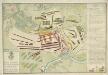
Plan de l'action de Fontenoy près de Tournay, entre l'armee dez alliez, & celle de la France, le 11 mai 1745 = Plaan van de Actie voorgevallen tusschen de geallieerde armée, en die der fransen, te Fontenoy by Doornick, den 11 may 1745
La Haye : Husson
Plan parcellaire de la commune de Gaurain : avec les mutations
1 : 5000 Royal Library of Belgium Map Room Popp, Philippe Christian (1805-1879) Popp, Philippe Christian (1805-1879)
Plan parcellaire de la commune de Vezon : avec les mutations
1 : 5000 Royal Library of Belgium Map Room Popp, Philippe Christian (1805-1879) Popp, Philippe Christian (1805-1879)
Plan parcellaire de la commune de Maubray : avec les mutations
1 : 5000 Royal Library of Belgium Map Room Popp, Philippe Christian (1805-1879) Popp, Philippe Christian (1805-1879)
Plan parcellaire de la commune de Péronne lez-Antoing : avec les mutations
1 : 5000 Royal Library of Belgium Map Room Popp, Philippe Christian (1805-1879) Popp, Philippe Christian (1805-1879)
Plan parcellaire de la commune de Chercq : avec les mutations
1 : 5000 Royal Library of Belgium Map Room Popp, Philippe Christian (1805-1879) Popp, Philippe Christian (1805-1879)
Plan parcellaire de la commune de Hollain : avec les mutations
1 : 5000 Royal Library of Belgium Map Room Popp, Philippe Christian (1805-1879) Popp, Philippe Christian (1805-1879)
Plan parcellaire de la ville de Tournay : avec les mutations
1 : 5000 Royal Library of Belgium Map Room Popp, Philippe Christian (1805-1879) Popp, Philippe Christian (1805-1879)
Plan de la ville et citadelle de Tournay
Call, Pieter van Husson
Plan de la ville et citadelle de Tournay
1 : 10000 P v. Cal s[culpsit]
Plan parcellaire de la commune de St. Maur : avec les mutations
1 : 5000 Royal Library of Belgium Map Room Popp, Philippe Christian (1805-1879) Popp, Philippe Christian (1805-1879)
Plan parcellaire de la commune de Warchin : avec les mutations
1 : 5000 Royal Library of Belgium Map Room Popp, Philippe Christian (1805-1879) Popp, Philippe Christian (1805-1879)
Plan parcellaire de la commune de Barry : avec les mutations
1 : 5000 Royal Library of Belgium Map Room Popp, Philippe Christian (1805-1879) Popp, Philippe Christian (1805-1879)
Plan parcellaire de la commune de Wasmes-Audemez : avec les mutations
1 : 5000 Royal Library of Belgium Map Room Popp, Philippe Christian (1805-1879) Popp, Philippe Christian (1805-1879)
Mons oder Bergen in Henegau mitt angraenzenden Orthen
1 : 150000 Mollova mapová sbírka Bodenehr, Gabriel Bodenehr, Gabriel
Carte Particuliere des Environs de Lille Tournay, Valenciennes, Bouchain, Douay, Arras, Bethune
1 : 116600 Mollova mapová sbírka Fricx, Eugène Henry Covens, Johannes I
Le Diocese de Tournay
1 : 150000 Mollova mapová sbírka Cappelier, Bernard Jaillot, Alexis Hubert
Carte particuliere des environs de Lille, Tournay, Valenciennes, Bouchain, Douay, Arras, Bethune
1 : 116600 Mollova mapová sbírka Fricx, Eugène Henry Harrewyn, Jacques Fricx, Eugené Henry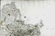
[Lille]
1 Blatt : 60 x 91 cm s.n.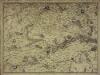
Carte particuliere des environs de Lille, Tournay, Valenciennes, Bouchain, Douay, Arras, Bethune
1 Karte : Kupferdruck ; 40 x 55 cm Fricx; Harrewijn chez Eugene Henry Fricx ruë de la Madelene
Galloflandria
1 : 170000 Douai (Francie) Doué, Martin Blaeu, Willem Janszoon Guiljelmus Blaeu