Maps of Europe

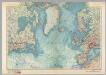
Pascaarte van alle de Zécusten van Europa
Blaeu, Willem Janszoon
Pas-kaart van Europa
1 Karte : Kupferdruck ; 42 x 53 cm Doncker by Hendrick Doncker inde Nieubrugsteegh
Ubersicht von Europa; mit ethnograph.
1 : 19008000 Berghaus, Heinrich
Das östliche und nördliche Europa
1 Karte : Kupferdruck ; 22 x 34 cm Reilly Franz J. J. von Reilly
Europa
E. von Sydow's Schul-Atlas in sechs und dreissig Karten Sydow, Emil von bei Justus Perthes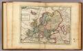
Europe.
1 : 29000000 Moll, Herman, d. 1732
Europa
1 : 30000 Evropa
[Übersicht von Europa mit ethnograph. Begränzung der einzelnen Staaten, und den Völker-Sitzen in der Mitte des 19ten Jahrhunderts]
Zweiter Band, enthaltend in vier Abtheilungen die Vertheilung der Organismen: 5. Pflanzen-Geographie, 6. Thier-Geographie, 7. Anthropographie, 8. Ethnographie Humboldt, Alexander von Verlag von Justus Perthes
Itinéraires du yacht "Princesse Alice" dans l'Océan atlantique nord, dans la Méditerranée et dans l'Océan glacial arctique, de 1891 a 1899
Atlantský oceán Tollemer, A. Imprimerie Vieillemard
Europa
1 Karte : Kupferdruck ; 47 x 55 cm Walch Johann Walch
Europa
1 Karte : Kupferdruck ; 21 x 26 cm Reilly Franz J. J. von Reilly
Europa mit politischer Begränzung der einzelnen Staaten
Hand-Atlas über alle Theile der Erde nach dem neuesten Zustande und über das Weltgebäude Stieler, Adolf bei Justus Perthes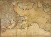
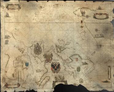
Nouvelle carte des decouvertes faites par des vaisseaux russiens aux côtes inconnues de l'Amerique septentrionale avec les pais adiacents
1 Karte auf 2 Blatt : Kupferdruck ; 44 x 62 cm Rey; Schenk chez Marc Michel Rey
Europa
E. von Sydow's Schul-Atlas in sechs und dreissig Karten Sydow, Emil von bei Justus Perthes
Evropa
1 Karte : Kupferdruck ; 38 x 46 cm Mercator; Mercator; Hondius Henricus Hondius
Evropa
1 Karte : Kupferdruck ; 38 x 46 cm Mercator; Mercator; Hondius Henricus Hondius?
Evropa
1 Karte : Kupferdruck ; 38 x 46 cm Mercator; Mercator; Hondius Jodocus Hondius
Evropa exactissime descripta
1 Karte : Kupferdruck ; 38 x 50 cm Hondius; Janssonius sumptibus Ioannis Ianssonii
Europa delineata et recens edita
1 Karte : Kupferdruck ; 42 x 54 cm Visscher Visscher
Evropa exactissime descripta
1 Karte : Kupferdruck ; 38 x 50 cm Hondius sumptibus auctoris
Carte de l'Evrope
1 Karte : Kupferdruck ; 37 x 49 cm Bertius; Tavernier chez Melchior Tauernier graueur et imprimeur du roy pour les tailles douces demeurant en l'isle du Palais sur le quay qui regarde la Megizerie
Europa
Schul-Atlas über alle Theile der Erde nach dem neuesten Zustande, und über das Weltgebäude Stieler, Adolf bei Justus Perthes
Moscovia.
from A new systeme of the mathematicks: containing I. Arithmetick, as well natural and decimal, as in species, or the principles of algebra. II. Practical geometry, together with the first six books of Euclid's Elements, as also the eleventh and twelfth, symbo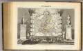
Europe.
1 : 40000000 Levasseur, Victor.
Europa recens descriptia. [Karte], in: Theatrum orbis terrarum, sive, Atlas novus, Bd. 1, S. 34.
1 Karte aus Atlas Blaeu, Joan Blaeu, Willem Janszoon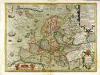
Nova Europæ descriptio
1 Karte : Kupferdruck ; 36 x 48 cm Hondius; Hondius Jodocus Hondius excudit
Nova Europæ descriptio
1 Karte : Kupferdruck ; 35 x 48 cm Hondius Jodocus Hondius excudit
Europa recens descripta [Karte], in: Le théâtre du monde, ou, Nouvel atlas contenant les chartes et descriptions de tous les païs de la terre, Bd. 1, S. 36.
1 Karte aus Atlas Blaeu, Willem Janszoon und Blaeu, Joan Blaeu, Willem Janszoon