Maps of Kreis Unna
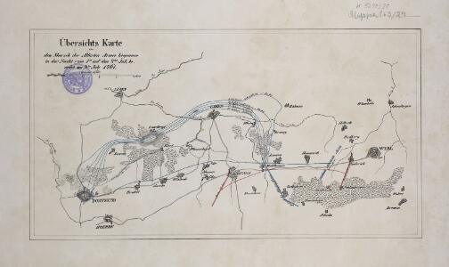
Übersichts Karte für den Marsch der Aliirten Armee, begonnen in der Nacht vom 1ten auf den 2ten Juli, beendet am 4ten Juli 1761
1 : 86400
Meßtischblatt 2507 : Unna, 1936
1 : 250000 Unna. - Hrsg. 1894, bericht. 1927, gedr. [19]36. - 1:25000. - [Berlin]: Reichsamt für Landesaufnahme, 1936. - 1 Kt.
Meßtischblatt 2506 : Kamen, 1932
1 : 250000 Kamen. - Hrsg. 1894, bericht. 1927, einz. Nachtr. 1931, gedr. [19]32. - 1:25000. - [Berlin]: Reichsamt für Landesaufnahme, 1932. - 1 Kt.
Meßtischblatt 2508 : Werl, 1927
1 : 250000 Werl. - Hrsg. 1897, einz. Nachtr. 1927. - 1:25000. - [Berlin]: Reichsamt für Landesaufnahme, 1927. - 1 Kt.
Meßtischblatt 2508 : Werl, 1897
1 : 250000 Werl. - Aufn. 1895. - 1:25000. - [Berlin]: Reichsamt für Landesaufnahme, 1897. - 1 Kt.
Meßtischblatt 2433 : Lünen, 1914
1 : 250000 Lünen. - Aufn. 1892, hrsg. 1894, Aufl.-dr. 1914. - 1:25000. - [Berlin]: Reichsamt für Landesaufnahme, 1914. - 1 Kt.
Meßtischblatt 2433 : Lünen, 1907
1 : 250000 Lünen. - Aufn. 1892, hrsg. 1894, bericht. 1907. - 1:25000. - [Berlin]: Reichsamt für Landesaufnahme, 1907. - 1 Kt.
Meßtischblatt 2434 : Hamm, 1914
1 : 250000 Hamm. - Aufn. 1892, hrsg. 1894, Aufl.-dr. 1914. - 1:25000. - [Berlin]: Reichsamt für Landesaufnahme, 1914. - 1 Kt.
Meßtischblatt 2505 : Dortmund, 1927
1 : 250000 Dortmund. - Hrsg. 1894, bericht. 1927. - 1:25000. - [Berlin]: Reichsamt für Landesaufnahme, 1927. - 1 Kt.
Meßtischblatt 2435 : Rhynern, 1934
1 : 250000 Rhynern. - Hrsg. 1897, einz. Nachtr. 1927, gedr. [19]34. - 1:25000. - [Berlin]: Reichsamt für Landesaufnahme, 1934. - 1 Kt.
Uebersichts-Karte der Steinkohlenfelder des Rhein-Westfäl. Ruhrkohlenbeckens
1 : 62500 Ostblatt G. D. Baedeker

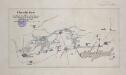
Plan de la Bataille de Vellingshausen
1 : 40000 Mollova mapová sbírka Bauer, Friedrich Wilhelm von Schley, Jacobus van der Gosse, Pierre
Meßtischblatt 2432 : Waltrop, 1907
1 : 250000 Waltrop. - Aufn. 1892, hrsg. 1894, bericht. 1907. - 1:25000. - [Berlin]: Reichsamt für Landesaufnahme, 1907. - 1 Kt.
Messtischblatt 2580 : Menden, 1931 Menden
1 : 250000 Menden. - Hrsg. 1894, bericht. 1931. - 1:25000. - [Berlin]: Reichsamt für Landesaufnahme, 1931. - 1 Kt.
Messtischblatt 2580 : Menden, 1907 Menden
1 : 250000 Menden. - Aufn. 1892, hrsg. 1894, bericht. 1907. - 1:25000. - [Berlin]: Reichsamt für Landesaufnahme, 1907. - 1 Kt.
Messtischblatt 2579 : Hörde, 1935 Hörde
1 : 250000 Hörde. - Hrsg. 1894, bericht. 1932, einz. Nachtr. 1935. - 1:25000. - [Berlin]: Reichsamt für Landesaufnahme, 1935. - 1 Kt.
Messtischblatt 2581 : Neheim, 1926 Neheim
1 : 250000 Neheim. - Aufn. 1894, einz. Nachtr. 1926. - 1:25000. - [Berlin]: Reichsamt für Landesaufnahme, 1926. - 1 Kt.
Messtischblatt 2581 : Neheim, 1896 Neheim
1 : 250000 Neheim. - Aufn. 1894. - 1:25000. - [Berlin]: Reichsamt für Landesaufnahme, 1896. - 1 Kt.

Comitatvs Marchia et Ravensberg
1 : 270000 Mollova mapová sbírka Schenk, Pieter Schenk, Peter I
Le Comté de la Marck, Les Seigneuries des Abbayes de Werden, d'Essen, et la Ville Imperiale de Dortmundt
1 : 230000 Mollova mapová sbírka Sanson, Guillaume Ottens, Josua
Le Comté de la Marck, Les Seigneuries des Abbayes de Werden, d'Essen, et la Ville Imperiale de Dortmundt
1 : 230000 Mollova mapová sbírka Sanson, Guillaume Jaillot, Alexis Hubert
[16], uit: Hydro-Oro und Chorographische General Karte des Koenigreichs der Niederlande und der angrenzenden Länder bis Paris : mit der Angabe der Kunst und Heer-Strassen und der Entfernung der Poststationen / ... zusammengetragen und reducirt von ... Wilhelm Müller
1 : 400000 titelvariant: Generalkarte des Koenigreichs Hannover; Annotatie: 1e supplement bij: Generalkarte des Koenigreichs Hannover (1818) Müller, Wilhelm (fl. 1818) [Hannover : Wilhelm Müller]
Carte du Comté de la Marck
1 : 160000 Mollova mapová sbírka Le Rouge, Georges-Louis Le Rouge, Georges-Louis
COMITATVS | MARCHIA | ET | RAVENSBERG
[Amsterdam : Joan Blaeu]
Le Comté De La Marck, Les Seigneuries Des Abbayes De Werden, D'Essen, Et La Ville Imperiale De Dortmundt. [Karte], in: Atlas nouveau, contenant toutes les parties du monde [...], Bd. 1, S. 226.
1 Karte aus Atlas Sanson, Nicolas Jaillot, Alexis Hubert und Mortier, Pieter
Le Duché de Westphalie
1 : 250000 Mollova mapová sbírka Sanson, Guillaume Covens, Johannes I
Le Duché de Westphalie
1 : 250000 Mollova mapová sbírka Sanson, Guillaume Jaillot, Alexis Hubert