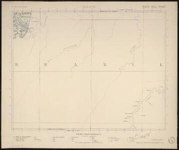
Maps of Leticia

Mapa del Peru
1 : 500000 Raimondi, Antonio 1826-1890 Paris : Erhard Frères
Partie, Colombie, Bresil. Amer. Merid. 9.
1 : 1641836 Vandermaelen, Philippe, 1795-1869
Lecho, Rio Amazonas; Corte vertical, camino de Lima-Cerro de Pasco.
Paz Soldan, Mariano Felipe, 1821-1886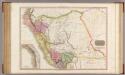
Peru.
1 : 3125000 Pinkerton, John, 1758-1826
Mapa del Peru
1 : 5000000 Raimondi, Antonio 1826-1890 Paris : Erhard Frères
New Grenada.
1 : 3400000 Pinkerton, John, 1758-1826
Mapa de los ferrocarriles del Peru : de sus principales vias de comunicación terrestres, fluviales y maritimas, y de la futura red ferroviaria según los proyectos formulados con indicación de los vias interfluviales llamadas varaderos
1 : 3000000 Vallejos Z., Camilo Lit. tip. Badiola y Berrio
Charte der Provinz oder Audiencia von Lima oder des alten Königreichs Peru
Map Of Peru.
1 : 6336000 Lea, I.
Geographisch-statistische und historische Charte von Peru
1 : 3500000 gezeichnet von Finlayson Weimar : Verlag des Geographischen Instituts
Peru.
1 : 11088000 Lucas, Fielding Jr.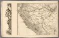
(Sheet 3) Mapa Geografico De America Meridional.
1 : 4335200 Ricarte, Hippolytus
Carta jeogràfica del desierto i cordilleras de Atacama
1 : 1000000 Chile. Dirección General de Obras Públicas. Seccion de Jeografia y Minas Dirección General de Obras Públicas. Seccion de Jeografia y Minas
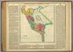
Peru
1 : 6530000 Peru Finlayson im Verlage des Geographischen Instituts
Peru And Bolivia.
1 : 8236800 Colton, G.W.
Ttahuantin-Suyu, or, the empire of the Yncas (except Quito and Chile) : in its four great divisions of Chincha-Suyu, Cunti-Suyu, Anti-Suyu, Colla-Suyu : with their tribes and ayllus or lineages, also the routes of the Ynca conquerors
1 : 3000000 Markham, Clements R. (Clements Robert), Sir, 1830-1916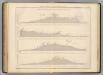
Coupe de divers passages, Cordillere des Andes.
1 : 1949000 Martin de Moussy, V. (Victor), 1810-1869
Peru.
1 : 11000000 Arrowsmith, Aaron; Lewis, Samuel
Peru
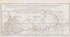
Carte du cours du Maragnon ou de la Grande Riviere des Amazones.
1 : 4000000 En 1743, Charles-Marie de La Condamine, un científico francés que hacía parte de la Expedición Geodésica al Virreinato de Perú, encargada de medir la forma de la Tierra en el Ecuador, emprendió su viaje de regreso a Europa por el Río Amazonas con la intención de corregir los mapas europeos sobre la región Amazónica, y evaluar la presencia real de los españoles y portugueses en la zona. La Condamine compara los resultados de sus cálculos y observaciones con los del jesuita Samuel Fritz, quien había también recorrido el río y publicado en 1707 un mapa titulado “El Gran Rio Marañón, o Amazonas con la Misión de la Compañía de Jesús". En puntillado La Condamine contrasta el trazado del curso del Río y su desembocadura del mapa de Fritz. La Condamine, Charles Marie de (1701-1774)
Facsimile: Part of South America by D'Anville.
1 : 63400000 Anville, Jean Baptiste Bourguignon d, 1697-1782
Terra Firma et Novum Regnum Granatense et Popayan
from America: being the latest, and most accurate description of the Nevv vvorld; containing the original of the inhabitants, and the remarkable voyages thither. The conquest of the vast empires of Mexico and Peru, and other large provinces and territories, with the several European plantations in those parts. Also their cities, fortresses, towns, temples, mountains, and rivers. Their habits, customs, manners, and religions. Their plants, beasts, birds, and serpents. With an appendix, containing, besides several other considerable additions, a brief survey of what hath been discover'd of the vnknown south-land and the Arctick region. Collected from most authentick authors, augmented with later observations, and adorn'd with maps and sculptures, by John Ogilby ...
Peru.
1 : 5400000 Hall, S. (Sidney)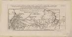
Carte du cours du Maragnon ou de la grande Riviere des Amazones : dans sa partie navigable depuis Jaen de Bracamoros jusqu'à son embouchure et qui comprend la province de Quito, et la côte de la Guiane depuis le Cap de Nord jusqu'à Essequebè : levée en 1743 et 1744 et assujettie aux observations astronomiques : augmentée du cours de la Riviére Noire et d'autres détails tirés de divers mémoires et routiers manuscrits du voyageurs modernes
1 : 11500000 La Condamine, Charles-Marie de, 1701-1774 Académie des Sciences
Venezuela, Colombia and Ecuador.
1 : 7000000 Colton, G.W.
South America 2.
1 : 2800000 Arrowsmith, Aaron
Venezuela, New Granada (Colombia) and Ecuador.
1 : 7200000 Colton, G.W.
Mapa, Ecuador, Peru y Bolivia, 1826.
1 : 5350000 Codazzi, Agustin, 1793-1859
Peru and Bolivia.
1 : 9000000 Colton, G.W.