Maps of Planalto Do Mato Grosso

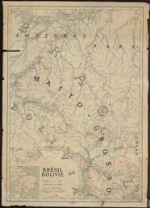
Brésil-Bolivie, Itinéraire Buenos Aires-Manaos et Route transcontinentale Atlantique-Pacifique
1 : 2000000 Courteville, Roger; France. Service géographique de l'armée [Paris] : Service géographique de l'armée impr.
Das obere Stromgebiet des Rio Madeira, nebst den angränzenden Ländern
Madeira, řeka (Bolívie a Brazílie) Mayr, Wilhelm
Partie du Bresil. Amer. Merid. 16.
1 : 1641836 Vandermaelen, Philippe, 1795-1869
Partie du Bresil. Amer. Merid. 22.
1 : 1641836 Vandermaelen, Philippe, 1795-1869
Partie, la Plata. Amer. Merid. 26.
1 : 1641836 Vandermaelen, Philippe, 1795-1869
Partie du Bresil. Amer. Merid. 17.
1 : 1641836 Vandermaelen, Philippe, 1795-1869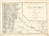
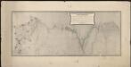
Map of the river Pilcomayo

Partie du Bresil. Amer. Merid. 10.
1 : 1641836 Vandermaelen, Philippe, 1795-1869
Map of the river Pilcomayo
Plano topografico de la region norte argentina limitrofe con Bolivia
1 : 575000 (Argentine) Comision Argentina Demarcadora de Limites con Bolivia [Buenos Aires] :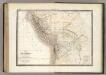
Perou, Haut Perou.
1 : 6800000 Lapie, M. (Pierre), 1779-1850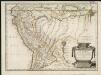
Le Perou
1 : 7033000
Perou, Bolivie.
1 : 8000000 Garnier, F. A., 1803-1863
Carte du Perou, pour servir à I'histoire des Incas et à celle de l'etat present de cette province
1 : 195000
PARAGVAY, Ó | PROV. DE RIO DE LA PLATA | cum regionibus adiacentibus | TVCVMAN | et | STA. CRVZ DE LA SIERRA.
AMSTELODAMI, | Guiljelmus Blaeuw | excudit.
Peru and Bolivia.
1 : 8000000 Tanner, Henry S.
Brazil.
1 : 35000000 Fenner, Rest.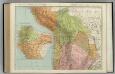
Chile, Bolivia, Peru, Ecuador, Uruguay, Paraguay, Argentine Republic. (northern half).
1 : 5020000 Rand McNally and Company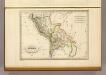
Perou et Bolivia.
1 : 14000000 Malte-Brun, Conrad, 1775-1826
Perou, Bolivie, Chili, Argentine, Paraguay, Uruguay.
1 : 8500000 Levasseur, E.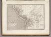
Perou et Bolivia.
1 : 8200000 Montemont, A.
Mappa del Perù
1 : 3000000 Barrera, Daniel Imprenta Lemercier
Recens elaborata mappa geographica regni Brasiliae in America Meridionali maxime celebris
1 : 6000000
Map of the valley of the Amazon : to accompany Lt. Herndon's report
1 : 6750000 Elliott, H. C A. Hoen
Map of the valley of the Amazon : to accompany Lt. Herndon's report
1 : 6500000 Elliott, H. C. (Henry C.) s.n.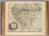
Peru, Amazones.
1 : 10000000 Bowen, Emanuel
Peru and Bolivia.
1 : 8200000 Colton, G.W.
Peru And Bolivia.
1 : 8200000 Tanner, Henry S.
Peru And Bolivia.
1 : 8200000 Tanner, Henry S.