Maps of Béchar

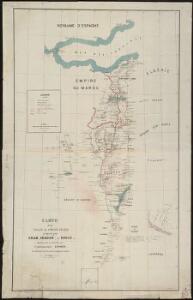
Carte d'un tracé d'un chemin de fer proposé par Oran, Sebdou, le Touat
1 : 1600000 Kramer Oran : Lith. Collet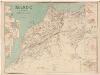
Maroc
1 : 1000000 Flotte de Roquevaire, R. de Maison Andriveau-Goujon, Henry Barrère Editeur
Carte générale de l'Algérie à l'échelle de 1 m. pour 1,600,000 m
1 : 1600000 Westblatt Duveyrier, Henri Dépôt de la Guerre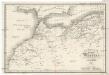
Das Kaiserreich Fez und Marokko nebst einem Theile der franz. Provinz Algier
1 : 3000000 Alžírsko Wenng, C. F.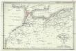
Das Kaiserreich Fez und Marokko
1 : 3000000 Alžírsko Wenng, C. F.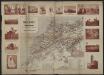
Carte du Maroc et de la frontière algérienne dressée au Bureau Militaire du Petit Journal
1 : 2000000 Paris :
Marokko
1 : 3000000 Glogau : Flemming
Marokko.
1 : 2800000 Flemming, Carl
Maroc carte politique
Vidal de La Blache, Paul
Maroc carte physique
Vidal de La Blache, Paul
Nouvelle carte du Maroc
1 : 2775000 A. Taride Paris : A.Taride
Maroc. Afrique 1.
1 : 1641836 Vandermaelen, Philippe, 1795-1869
Physisch-geographische Skizze von Marokko
1 : 4000000 Maroko Fischer, Theobald Militärgeographisches Institut
Partie, Desert de Sahara. Afrique 7.
1 : 1641836 Vandermaelen, Philippe, 1795-1869
Algérie, colonie française. Région du sud
1 : 5000000 Levasseur, Victor 1800-1870 Paris : Combette
Feuille 43 (A VII), uit: Carte géologique internationale de l'Europe : la carte, votée au congrès géologique international de Bologne en 1881, est exécutée conformément aux décisions d'une commission internationale, avec le concours des gouvernements, sous le dir. de M.M. Beyrich et Hauchecorne
Annotatie: Blad 48 gamme des couleurs; blad 49: bladwijzer en titelblad Heinrich Ernst Beyrich 1815-1896; Wi. Hauchecorne Berlin : Reimer / (Berlin: Institut lithographique)
Maroc au 1/1 500 000. Carte des étapes. Routes et pistes carrossables. 1924
1 : 1500000 Maroc. Service géographique Service géographique du Maroc
43. Spagna, Portogallo sud.
1 : 1500000 Touring club italiano
Région frontière Algéro-Marocaine
1 : 500000 S. G. de l'Armée
Dépt D’ Oran carte politique
Vidal de La Blache, Paul
Dépt D’ Oran carte physique
Vidal de La Blache, Paul
A chart of the sea coast of SPAIN from the Straits mouth to C de Gat and of the sea coast of BARBARY from the Straits mouth to C de Hone
from The sea-atlas : containing an hydrographical description of most of the sea-coasts of the known parts of the world.
Carte particuliere des côstes d'Espagne et Barbarie depuis Gibralter jusqu'à C. de Palle et depuis Ceuta jusqu'au C. Ferat
Spain Henri Michelot Gerard van Keulen
Granata, Et Murcia Regna. [Karte], in: Novus atlas absolutissimus, Bd. 6, S. 46.
1 Karte aus Atlas Janssonius Offizin
Granata, Et Murcia Regna. [Karte], in: Le théâtre du monde, ou, Nouvel atlas contenant les chartes et descriptions de tous les païs de la terre, Bd. 2, S. 227.
1 Karte aus Atlas Blaeu, Willem Janszoon und Blaeu, Joan Blaeu, Willem Janszoon
Granata, Et Murcia Regna. [Karte], in: Theatrum orbis terrarum, sive, Atlas novus, Bd. 2, S. 234.
1 Karte aus Atlas Blaeu, Joan Blaeu, Willem Janszoon
Granata, Et Murcia Regna. [Karte], in: Gerardi Mercatoris et I. Hondii Newer Atlas, oder, Grosses Weltbuch, Bd. 2, S. 198.
1 Karte aus Atlas Mercator, Gerhard und Hondius, Jodocus Jansson, Jan
Granata, et Mvrcia regna
1 Karte : Kupferdruck ; 36 x 48 cm Janssonius Joannes Janssonius
Granata, et Mvrcia regna
1 Karte : Kupferdruck ; 36 x 48 cm Blaeu Joan Blaeu