Maps of Tsabit District

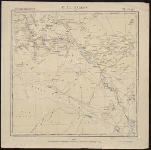
Maroc (500 000 e). Oued Saoura
1 : 500000 France. Service géographique de l'armée Service géographique de l'Armée
171: Maroc [zuidblad], uit: Maroc en 2 feuilles / Pneu Michelin
1 : 1000000 titelvariant: Carte Michelin Maroc Michelin Paris : Services de Tourisme Michelin
Partie, Desert de Sahara. Afrique 7.
1 : 1641836 Vandermaelen, Philippe, 1795-1869
Carte générale du Maroc à l'échelle de 1 : 500 000 e. Beni Abbès
1 : 500000 Maroc. Service géographique Rabat : Service géographique du Maroc
Carte géologique provisoire du Maroc
1 : 1500000 Maroko Gentil, Louis Emile Larose
Carte d'un tracé d'un chemin de fer proposé par Oran, Sebdou, le Touat
1 : 1600000 Kramer Oran : Lith. Collet
Maroc
1 : 1000000 Flotte de Roquevaire, R. de Maison Andriveau-Goujon, Henry Barrère Editeur
Esquisse du Sahara algérien
1 : 2500000 Alger : imp. de A. Jourdan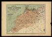
Mapa del imperio de Marruecos ó Moghreb-El-Aksá / trazado con los datos mas recientes por Benito Chias y Carbó, ingeniero militar; J. Soler g[rabó]
1 : 3000000 1 Mapa, col. Datació aproximada. Chias Carbó, Benet [Alberto Martin editor?]
Fessae et Marocchi Regna. [Karte], in: Gerardi Mercatoris Atlas, sive, Cosmographicae meditationes de fabrica mundi et fabricati figura, S. 502.
1 Karte aus Atlas Mercator, Gerhard Montanus, Petrus
Carte des divisions administratives des territoires du sud
1 : 3200000 Calléja, N.; Gouvernement général de l'Algérie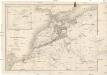
Carte de l'empire de Maroc
1 : 2000000 Gibraltarský průliv Renou, E. Delsol, Th. Langlois et Leclercq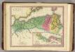
Africa Antiqua. (1826)
1 : 6600000 Tanner, Henry S.
Northern Africa.
1 : 7920000 Tallis, J. & F.
Carte des divisions administratives de l'Algérie
1 : 3200000 Calléja, N.; Algérie. Direction de l'agriculture et de la colonisation Alger : Imp. Jourdan
Maroc au 1 500 000e
1 : 1500000 Maroko
Marocco, Algeria & Tunis.
1 : 4552426 Johnston, Alexander Keith
164-165. Africa, North-west. The World Atlas.
1 : 3750000 USSR (Union of Soviet Socialist Republics).
Algeria, Tunis, Morocco.
1 : 6950000 Rand McNally and Company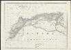
Karte von Marocco, Algier & Tunis : nach der Carte de L'Algérie dressée au Dépôt Général de la Guerre sous la direction de Pelet d'après les levés et les reconnaissances des Officiers d'Etat-major, les relèvemens de la Marine, les renseignemens recueillis en Afrique, les itineraires anciens et les voyages modernes de Shaw, Peyssonel &a. und nach J. Arrowsmith
1 : 3150000 entworfen, gezeichnet und graviert von Albrecht Platt Magdeburg : Geogr. lith. Institut v. Albr. Platt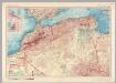
Morocco, Algeria, Tunisia. Pergamon World Atlas.
1 : 5000000 Polish Army Topography Service
Carte generale de toute l'Europe, 4
1 Blatt : 56 x 48 cm J.M. Will
Nord-Africa Berberei
1 : 9678000 Afrika severní Schlieben Gleditsch
Algérie
1 : 3500000 Alžírsko Gouvernement général de l'Algérie, Service cartographique
Algérie
1 : 3500000 Alžírsko Gouvernement général de l'Algérie, Service cartographique
In notitiam ecclesiasticam Africæ tabula geographica
1 : 5700000
[133][136] Occidentalior tractus Maris Mediterranei, uit: Atlas sive Descriptio terrarum orbis
Annotatie: Gedigitaliseerde versie. Amsterdam. Heiloo : Picturae (vervaardiger), 2015. tiff-bestand. Gedigitaliseerd: 07-01-2015; Origineel: Universiteitsbibliotheek Vrije Universiteit (XL.05127.-) ; Netherlands; Titelpagina ontbreekt Wit, Frederik de Amsterdam : Frederick de Wit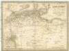
Berberei enthält das Reich Fez und Marocco, Algier, Tunis u. Tripoli
1 : 4500000 Afrika severní Biller, B. Tranquillo Mollo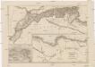
Mauritania, Africa propria, Cyrenaica
1 : 330000 Afrika severní Reichard, Christian Gottlieb Campius, D. a D. Campio