Maps of Settat

Carte générale du Maroc à l'échelle de 1 : 500 000 e. Mazagan
1 : 500000 Maroc. Service géographique Rabat : Service géographique du Maroc
Carte provisoire de la région de Casablanca d'après la carte du Maroc au 500 000e
1 : 200000 France. Service géographique de l'armée [Paris] : Service géographique de l'armée
Maroc (500 000 e). Mazagan
1 : 500000 France. Service géographique de l'armée Service géographique de l'Armée
Casablanca
1 : 250000 Larras, Nestor Prosper 18..-19..; France. Service géographique de l'armée Paris : H. Barrère
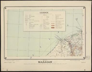
Mazagan
1 : 250000 Larras, Nestor Prosper 18..-19..; France. Service géographique de l'armée Paris : H. Barrère
Nord-Atlantischer Ozean
1 : 750000 Afrika Reichs-Marine-Amt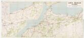
170: Maroc [noordblad], uit: Maroc en 2 feuilles / Pneu Michelin
1 : 1000000 titelvariant: Carte Michelin Maroc Michelin Paris : Services de Tourisme Michelin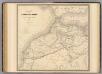
Maroc.
1 : 1720000 Andriveau-Goujon, J.
Physisch-geographische Skizze von Marokko
1 : 4000000 Maroko Fischer, Theobald Militärgeographisches Institut
Maroc
1 : 3000000 Genève : imp. F. Noverraz et fils
FEZZÆ | ET | MAROCCHI | REGNA AFRICÆ | CELEBERRIMA
describente | Abrah: Ortelius. [Amsterdam : Joan Blaeu]
Fezzae Et Marocchi Regna Africae Celeberrima [Karte], in: Theatrum orbis terrarum, sive, Atlas novus, Bd. 2, S. 293.
1 Karte aus Atlas Blaeu, Joan Blaeu, Willem Janszoon
Fezzae Et Marocchi Regna Africae Celeberrima [Karte], in: Novus Atlas, das ist, Weltbeschreibung, Bd. 2, S. 246.
1 Karte aus Atlas Blaeu, Joan Blaeu, Willem Janszoon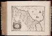
Fezzae et Marocchi regna Africae celeberrima, / describebat Abrah. Ortelius
1 : 3000000 Annotatie: Middenonder: Melvia Rio, middenboven: Atlanticvs, (met komma); Origineel is Blad 206 in atlas factice; Annotatie geografische gegevens: Met schaalstok; West boven Abraham Ortelius 1527-1598 [Amsterdami : apud Guiljelmum et Iohannem Blaeu]
Maroc au 1/1 500 000. Carte des étapes. Routes et pistes carrossables. 1924
1 : 1500000 Maroc. Service géographique Service géographique du Maroc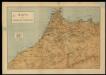
Mapa del imperio de Marruecos
1 Mapa. Datació aproximada. Lit. Mateu
Reiseweg im Marokkanischen Atlas-Vorland im Frühjahr 1899
1 : 2000000 Atlas (pohoří) Fischer, Theobald Gesellschaft für Erdkunde
Carte touristique du Maroc
1 : 500000 Casablanca (Maroko) Service géographique
Fezzae Et Marocchi Regna Africae Celeberrima [Karte], in: Le théâtre du monde, ou, Nouvel atlas contenant les chartes et descriptions de tous les païs de la terre, Bd. 2, S. 284.
1 Karte aus Atlas Blaeu, Willem Janszoon und Blaeu, Joan Blaeu, Willem Janszoon
Impero di Marocco.
1 : 2900000 Society for the Diffusion of Useful Knowledge (Great Britain)
Fezzae Et Marocchi Regna Africae Celeberrima [Karte], in: Gerardi Mercatoris et I. Hondii Newer Atlas, oder, Grosses Weltbuch, Bd. 2, S. 365.
1 Karte aus Atlas Mercator, Gerhard und Hondius, Jodocus Jansson, Jan
Maroc au 1 500 000e. Carte kilométrique des routes et chemins de fer
1 : 1500000 Maroc. Service géographique Rabat : Service géographique du Maroc
Maroc au 1 500 000e. Carte aéronautique donnant les caps et distances des principaux itinéraires
1 : 1500000 Maroc. Service géographique Rabat : Service géographique du Maroc
Maroc au 1 500 000e. Carte administrative. 1937
1 : 1500000 Maroc. Service géographique Rabat : Service géographique du Maroc
Maroc au 1 500 000e. Carte des tribus. 1935
1 : 1500000 Maroc. Service géographique Rabat : Service géographique du Maroc
Morocco.
1 : 2900000 Society for the Diffusion of Useful Knowledge (Great Britain)
Carte du Maroc
1 : 1500000 Maroko Gentil, Louis Emile Larose
Feuille 36 (A VI), uit: Carte géologique internationale de l'Europe : la carte, votée au congrès géologique international de Bologne en 1881, est exécutée conformément aux décisions d'une commission internationale, avec le concours des gouvernements, sous le dir. de M.M. Beyrich et Hauchecorne
Annotatie: Blad 48 gamme des couleurs; blad 49: bladwijzer en titelblad Heinrich Ernst Beyrich 1815-1896; Wi. Hauchecorne Berlin : Reimer / (Berlin: Institut lithographique)
Nordwestliches Africa oder das Sultanat Marocoo
Grosser Hand-Atlas über alle Theile der Erde in 170 Karten Meyer, J. Verlag des Bibliographischen Instituts