Maps of Homyel'

Théatre de la guerre actuelle, en Allemagne, en Pologne et en Turquie. n5, Brody
1 : 900000 Chanlaire, Pierre Grégoire 1758-1817 Paris : chez l'auteur P. G. Chanlaire
Gipsometričeskaja karta Polěs'ja s oboznačenijem kanalizacii
1 : 1250000 Polesí
Geologičeskaja karta Polěs'ja
1 : 1250000 Polesí
Übersichtskarte von Mittel - Europa

Übersichtskarte von Mittel - Europa

Übersichtskarte von Mittel - Europa

Brest-Litowsk, Pinsk, Ostrog, Kołki
1 : 750000 Brest (Bělorusko : oblast) Geng, K. K. u. k. Militärgeographisches Institut

Neue Generalkarte des Österr.-ungar.-russischen Kriegsschauplatzes

Generalkarte von Zentraleuropa

Generalkarte von Zentraleuropa

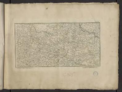
Li palatinati di Braclaw, e Kiowia / tratta dall'atlante polacco del Sig.r Rizzi Zanoni ; G. Zuliani
1 : 740000 1 Karte : Kupferdruck ; 40 x 31 cm Zuliani, Giuliano presso Antonio Zatta
Bez titulu: Šest listů speciálních map Ukrajiny

Umgegend von Kiew
Kiew, Umland
TRACTVS | BORYSTHENIS | Vulgo DNIEPR et NIEPR dicti, | à KIOVIA usque ad BOUZIN.
Amstelædami | Excud. I. BLAEV.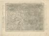
g. Volynskoj (Rjad XXII., list 6)


Speciální mapa západního Ruska

Speciální mapa západního Ruska

Speciální mapa západního Ruska
Österreich-Ungarns letzter Krieg
1 : 750000 Dunaj-delta (Rumunsko a Ukrajina) Verlag der Militärwissenschaftlichen Mitteilungen
Brody.
from Spezialkarte der osterreichisch-ungarischen Monarchie.
Beresteczko und Szczurowice.
from Spezialkarte der osterreichisch-ungarischen Monarchie.
Karte des Westlichen Russlands: Q39 Luck

Zloczow.
from Spezialkarte der osterreichisch-ungarischen Monarchie.
Łuck
1 : 75000 Luck-oblast (Ukrajina) Brantner, A. K. u. k. Militärgeographisches Institut