Maps of Masovian

Théatre de la guerre actuelle, en Allemagne, en Pologne et en Turquie. n3, Berlin
1 : 900000 Chanlaire, Pierre Grégoire 1758-1817 Paris : chez l'auteur P. G. Chanlaire
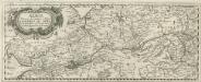
L'Alemagne 2.
1 : 1800000 Rizzi Zannoni, Giovanni Antonio Bartolomeo, 1736-1814
Herzogthum Warschau
1 : 2310000 Varšava (Polsko : oblast)

Polonia Et Silesia [Karte], in: Gerardi Mercatoris Atlas, sive, Cosmographicae meditationes de fabrica mundi et fabricati figura, S. 409.
1 Karte aus Atlas Mercator, Gerhard Montanus, Petrus
Polonia et Silesia
1 Karte : Kupferdruck ; 33 x 44 cm Mercator; Hondius Henricus Hondius
Polonia et Silesia
1 Karte : Kupferdruck ; 33 x 44 cm Mercator s.n.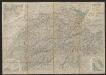
Polonia Et Silesia [Karte], in: Gerardi Mercatoris et I. Hondii Newer Atlas, oder, Grosses Weltbuch, Bd. 1, S. 340.
1 Karte aus Atlas Mercator, Gerhard und Hondius, Jodocus Jansson, Jan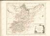

Mitteldeutschland
Volksschul-Atlas über alle Teile der Erde Lange, Henry Druck und Verlag von Georg Westermann
L'Empire, d'Allemagne
1 : 1200000 Mollova mapová sbírka Sanson, Nicolas Quasy, Robert
[Nordoestliches Deutschland]
Stieler's Hand-Atlas Stieler, Adolf bei Justus Perthes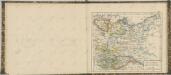

Le Cours de l'Elbe et de l'Oder où sont les Electorats de Saxe et de Brandebourg, les Duchés de Mekelbourg et de Pomeranie
1 : 1400000 Mollova mapová sbírka Duval, Pierre Duval, Pierre
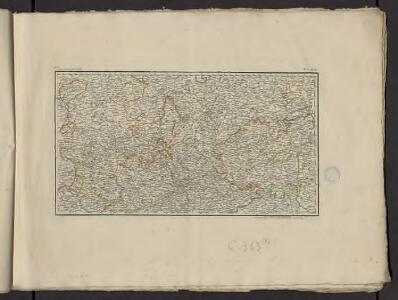
Operations Karte im Jahr 1759 ...

[Nord-Östliches Deutschland]
Hand-Atlas über alle Theile der Erde nach dem neuesten Zustande und über das Weltgebäude Stieler, Adolf bei Justus Perthes
Karte vom nördlichen Kriegsschauplatze
Prusko Jacob Dirnböck
TABULA NOVA POLONIAE et SILESIAE
1 : 1800000 Gdaňsk (Polsko) Goos, Abraham impreßa in aedibus Nicolaij Iohannis Vißcher
Brandenburg, Schlesien, Posen
Neuer Handatlas über alle Theile der Erde Kiepert, Heinrich Verlag von Dietrich Reimer
Die preusischen Provinzen Preussen und Posen und dan Königreich Polen
1 : 1220000 Polsko Gräf, C. Dellinger Geographisches Institut
Postkarte von dem Obersaechsischen und Niedersaechsischen Kreise
Polsko severozápadní Kühn, Ignaz im von Reilly'schen Landkarten und Kunstwerke Verschleiss Komptoir
Regnum Bohemiae eique annexae Provinciae ut Ducatus Silesiae Marchionatus Moraviae et Lusatiae Vulgo Die Erb-Landeren
1 : 945000 Mollova mapová sbírka Visscher, Nicolaes Jansz.
A map of Upper Saxony comprehending that part of Germany which is the present seat of war
1 : 2534400

Upper Saxony.
1 : 2900000 Bowen, Frances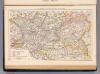
Brandenburg, Posen.
1 : 1350000 Andree, Richard
Sachsen
Allgemeiner Atlas [Walch, Johannes] im Verlag bei Johannes Walch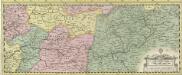
Albis Fluvius Germaniae celebris A Fontibus ad Ostia
1 : 880000 Mollova mapová sbírka Ottens, Joachim Ottens, Joachim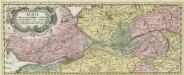
Albis Fluvius Germaniae celebris A Fontibus ad Ostia
1 : 880000 Mollova mapová sbírka Ottens, Joachim Ottens, Joachim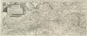
Eigentliche Vorstellung dess grossen Elb-Stroms in Deutschland, vom Ursprung biss zu seinen Ausfluss, mit seinen beyderseits einfliessenden Wassern und Flüssen
1 : 880000 Mollova mapová sbírka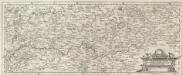
Eigentliche Vorstellung dess grossen Elb-Stroms in Deutschland, vom Ursprung biss zu seinen Ausfluss, mit seinen beyderseits einfliessenden Wassern und Flüssen
1 : 880000 Mollova mapová sbírka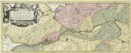
Albis Fluvius Germaniae celebris A Fontibus ad Ostia
1 : 860000 Mollova mapová sbírka Aveele, Johannes van den Schenk, Peter I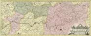
Albis Fluvius Germaniae celebris A Fontibus ad Ostia
1 : 860000 Mollova mapová sbírka Aveele, Johannes van den Schenk, Peter I