Maps of Staré Hradiště

Indikační skica mapy stabilního katastru pro obec Doubravice I.-III.
1 : 2880
Porostní mapa revíru Stéblová
1 : 10000
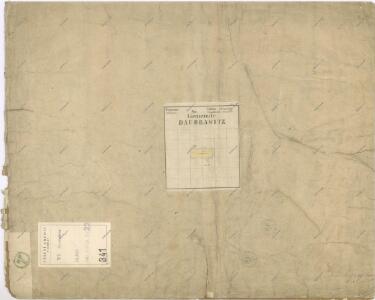
Daubrawitz - c1466-1-001 - Kaiserpflichtexemplar der Landkarten des stabilen Katasters
1 : 2880
Daubrawitz - c1466-1-003 - Kaiserpflichtexemplar der Landkarten des stabilen Katasters
1 : 2880
Daubrawitz - c1466-1-002 - Kaiserpflichtexemplar der Landkarten des stabilen Katasters
1 : 2880
Alt u.Neu Hradischt(Star.a Now.Hradisst) - c7259-1-001 - Kaiserpflichtexemplar der Landkarten des stabilen Katasters
1 : 2880
Alt u.Neu Hradischt(Star.a Now.Hradisst) - c7259-1-002 - Kaiserpflichtexemplar der Landkarten des stabilen Katasters
1 : 2880
Alt u.Neu Hradischt(Star.a Now.Hradisst) - c7259-1-004 - Kaiserpflichtexemplar der Landkarten des stabilen Katasters
1 : 2880
Alt u.Neu Hradischt(Star.a Now.Hradisst) - c7259-1-003 - Kaiserpflichtexemplar der Landkarten des stabilen Katasters
1 : 2880
Hospodářská mapa polesí Hrádek
1 : 5000
Porostní mapa lesů Explosie v Semtíně
1 : 5000
Hospodářská mapa revíru Stéblová, Hrádek 1916-1925
1 : 2880
Porostní mapa revíru Hrádek
1 : 2880
Mapa polesí Hrádek
1 : 5000
Indikační skica mapy stabilního katastru pro obec Doubravice I., II.
1 : 2880
Indikační skica mapy stabilního katastru pro obec Doubravice III.
1 : 2880
Ohrazenitz (Ohrazenice) - c5388-1-003 - Kaiserpflichtexemplar der Landkarten des stabilen Katasters
1 : 2880
Ohrazenitz (Ohrazenice) - c5388-1-001 - Kaiserpflichtexemplar der Landkarten des stabilen Katasters
1 : 2880
Ohrazenitz (Ohrazenice) - c5388-1-002 - Kaiserpflichtexemplar der Landkarten des stabilen Katasters
1 : 2880
Trnowa - c7978-1-002 - Kaiserpflichtexemplar der Landkarten des stabilen Katasters
1 : 2880
Trnowa - c7978-1-003 - Kaiserpflichtexemplar der Landkarten des stabilen Katasters
1 : 2880
Trnowa - c7978-1-001 - Kaiserpflichtexemplar der Landkarten des stabilen Katasters
1 : 2880
Indikační skica mapy stabilního katastru pro obec Ohrazenice I.
1 : 2880
Indikační skica mapy stabilního katastru pro obec Staré a Nové Hradiště a Cihelnu II.
1 : 2880
Hospodářská mapa revíru Stéblová, Hrádek 1916-1925
1 : 2880
Mapa propachtovaných pozemků na místě bývalého rybníka Rozkoš
1 : 2880
Indikační skica mapy stabilního katastru pro obec Staré a Nové Hradiště a Cihelnu I.
1 : 2880
Indikační skica mapy stabilního katastru pro obec Srch III.
1 : 2880
Indikační skica mapy stabilního katastru pro obec Pohránov II.
1 : 2880