Maps of Stéblová

Mapa revíru Hrádek
1 : 5000
Porostní mapa revíru Stéblová
1 : 10000
Indikační skica mapy stabilního katastru pro město (Lázně) Bohdaneč VII.
1 : 2880
Porostní mapa lesů Explosie v Semtíně
1 : 5000
Indikační skica mapy stabilního katastru pro obec Doubravice I.-III.
1 : 2880
Mapa pozemků bývalého rybníka Oplatil
1 : 5760
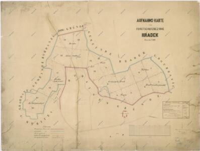
Hospodářská mapa polesí Hrádek
1 : 5000
Přehledová mapa pozemků bývalého rybníka Oplatil
1 : 4320
Porostní mapa revíru Hrádek
1 : 2880
Daubrawitz - c1466-1-001 - Kaiserpflichtexemplar der Landkarten des stabilen Katasters
1 : 2880
Daubrawitz - c1466-1-003 - Kaiserpflichtexemplar der Landkarten des stabilen Katasters
1 : 2880
Daubrawitz - c1466-1-002 - Kaiserpflichtexemplar der Landkarten des stabilen Katasters
1 : 2880
Mapa pozemků bývalého rybníka Oplatil
1 : 2880
Mapa polesí Hrádek
1 : 5000
Síťová mapa pozemků na území bývalého rybníka Oplatil
1 : 2880
Steblowa - c7325-1-004 - Kaiserpflichtexemplar der Landkarten des stabilen Katasters
1 : 2880
Steblowa - c7325-1-001 - Kaiserpflichtexemplar der Landkarten des stabilen Katasters
1 : 2880
Steblowa - c7325-1-002 - Kaiserpflichtexemplar der Landkarten des stabilen Katasters
1 : 2880
Steblowa - c7325-1-003 - Kaiserpflichtexemplar der Landkarten des stabilen Katasters
1 : 2880
Hospodářská mapa revíru Stéblová
1 : 2880
Mapa lesa Obora u Stéblové
1 : 2880
Obora Týniště a Oplatil u Stéblové
1 : 2880
Rositz (Rosice) - c6538-1-001 - Kaiserpflichtexemplar der Landkarten des stabilen Katasters
1 : 2880
Rositz (Rosice) - c6538-1-002 - Kaiserpflichtexemplar der Landkarten des stabilen Katasters
1 : 2880
Rositz (Rosice) - c6538-1-004 - Kaiserpflichtexemplar der Landkarten des stabilen Katasters
1 : 2880
Rositz (Rosice) - c6538-1-003 - Kaiserpflichtexemplar der Landkarten des stabilen Katasters
1 : 2880
Switkow - c7651-1-001 - Kaiserpflichtexemplar der Landkarten des stabilen Katasters
1 : 2880
Switkow - c7651-1-002 - Kaiserpflichtexemplar der Landkarten des stabilen Katasters
1 : 2880
Pachtovní mapa pozemků Oplatil
1 : 2880
Srnojed - c7209-1-001 - Kaiserpflichtexemplar der Landkarten des stabilen Katasters
1 : 2880