Maps of Staré Hodějovice

Hodonice o. Tábor 1
1 : 2880
Hodonice o. Tábor 1
1 : 2880
Hodowitz - c1922-1-006 - Kaiserpflichtexemplar der Landkarten des stabilen Katasters
1 : 2880
Hodowitz - c1922-1-001 - Kaiserpflichtexemplar der Landkarten des stabilen Katasters
1 : 2880
Hodowitz - c1922-1-002 - Kaiserpflichtexemplar der Landkarten des stabilen Katasters
1 : 2880
Hodowitz - c1922-1-005 - Kaiserpflichtexemplar der Landkarten des stabilen Katasters
1 : 2880
Hodowitz - c1922-1-008 - Kaiserpflichtexemplar der Landkarten des stabilen Katasters
1 : 2880
Hodowitz - c1922-1-003 - Kaiserpflichtexemplar der Landkarten des stabilen Katasters
1 : 2880
Hodowitz - c1922-1-004 - Kaiserpflichtexemplar der Landkarten des stabilen Katasters
1 : 2880
Hodowitz - c1922-1-007 - Kaiserpflichtexemplar der Landkarten des stabilen Katasters
1 : 2880
Strodenitz - c6556-1-003 - Kaiserpflichtexemplar der Landkarten des stabilen Katasters
1 : 2880
Strodenitz - c6556-1-004 - Kaiserpflichtexemplar der Landkarten des stabilen Katasters
1 : 2880
Strodenitz - c6556-1-002 - Kaiserpflichtexemplar der Landkarten des stabilen Katasters
1 : 2880
Strodenitz - c6556-1-006 - Kaiserpflichtexemplar der Landkarten des stabilen Katasters
1 : 2880
Strodenitz - c6556-1-001 - Kaiserpflichtexemplar der Landkarten des stabilen Katasters
1 : 2880
Strodenitz - c6556-1-005 - Kaiserpflichtexemplar der Landkarten des stabilen Katasters
1 : 2880
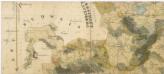
Plán železniční tratě v úseku Gmünd - České Budějovice, list 6 1
Situační plán obecních pozemků u Hodovic a Vidova 1

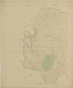
Ruden, Budweiser Kr[eis]
1 : 2880 Roudné (České Budějovice, Česko)
Doubravice o. České Budějovice 1
1 : 2880
Generální mapa panství Třeboň a inkorporovaných statků Bzí, Lomnice, Borovany, Třeboň, Hamr a Val 1

České Budějovice se situačním plánkem letiště
Administrativní mapa třeboňského panství se statky Bzí,Lomnice, Borovany,Hamr a Val 1


[Mapový list]
1 : 25000 Čechy (Česko) Vojenský zeměpisný ústav
Gradkartenblatt
1 : 25000 Čechy (Česko) Gerstner, Eduard von
III. vojenské mapování 4453/1
1 : 25000
[České Budějovice a okolí]
České Budějovice-oblast (Česko)
Vltava jižně od Prahy