Maps of Born a. Darß

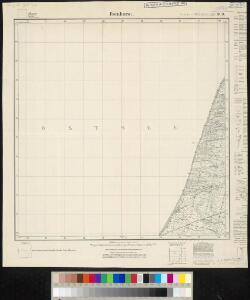
Meßtischblatt 309 : Ibenhorst, 1936
1 : 250000 Ibenhorst. - Hrsg. 1885, bericht. 1924. - 1:25000. - [Berlin]: Reichsamt für Landesaufnahme, 1936. - 1 Kt.
62. Barth. (Germany)
1 : 100000 Reichsamt fur Landesaufnahme
Composite: 62. Barth. (Germany)
1 : 100000 Reichsamt fur Landesaufnahme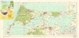
Bäderkarte Prerow Zingst Ahrenshoop Wustrow

12. Wiek a/R., uit: Topographische Uebersichtskarte des Deutschen Reiches / herausgegeben v. d. Kartogr. Abt. d. Königl. Preuß. Landesaufnahme
1 : 200000 titelvariant: Topogr. Übersichtskarte des Deutschen Reiches; Annotatie: Titel boven bladen ook: Topogr. Übersichtskarte des Deutschen Reiches; Annotatie geografische gegevens: Op elk blad twee maatstokken: 10 Kilometer = 5,5 cm; 1 geogr. Meile = 3,6 cm; Legenda onder op elk blad Königlich Preußische Landesaufnahme. Kartographische Abtheilung [S.l : Königlich Preußische Landesaufnahme, Kartographische Abtheilung]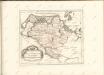

Mappa Ducatus Megalopolitani Nova :
1 : 190000 Mollova mapová sbírka
Karte von Neu-Vorpommern und der Insel Rügen
1 : 200000 Přední Pomořansko (Německo) Hagenow, Fr. von Hube, C. A. Fr. v. Hagenow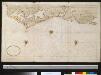
Gedeelte van de kust van Mecklenburg bij Rostock
Germany Gerard van Keulen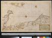
Nieuwe afteekening van een gedeelte van de Belt Zee vervattende de zeekusten van Holsteijn en Mekelenburg van het eijlant Femeren tot aan Mardorp in Pomeren
Germany Johannes van Keulen
26. Stralsund, uit: Topographische Uebersichtskarte des Deutschen Reiches / herausgegeben v. d. Kartogr. Abt. d. Königl. Preuß. Landesaufnahme
1 : 200000 titelvariant: Topogr. Übersichtskarte des Deutschen Reiches; Annotatie: Titel boven bladen ook: Topogr. Übersichtskarte des Deutschen Reiches; Annotatie geografische gegevens: Op elk blad twee maatstokken: 10 Kilometer = 5,5 cm; 1 geogr. Meile = 3,6 cm; Legenda onder op elk blad Königlich Preußische Landesaufnahme. Kartographische Abtheilung [S.l : Königlich Preußische Landesaufnahme, Kartographische Abtheilung]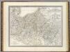
Mecklenburg-Schwerin, Mecklenburg-Strelitz.
1 : 360000 Weiland, C. F. (Carl Ferdinand), d. 1847
Charte von dem Gross-Herzogthümern Mecklenburg-Schwerin, und Mecklenburg-Strelitz
1 : 359000 Meklenbursko (Německo) Streit, Friedrich Wilhelm Friedrich Campe
Mecklenburg.
1 : 595000 Flemming, Carl
Sect. 2: Stralsund, uit: Geologische Karte des Deutschen Reichs in 27 Blaettern / [von] Richard Lepsius ; Red. von C. Vogel
1 : 500000 Annotatie: Blad 18 ontbreekt; Een aantal bladen op linnen; Een aantal bladen gereviseerd 1913-1914; Annotatie geografische gegevens: Met schaalstokken o.a. in kilometers; Legenda Carl Vogel 1828-1897 Gotha : Justus Perthes
Ducatus Meklenburgicus
1 : 460000 Mollova mapová sbírka Ottens, Reinier Ottens, Josua
Ducatus Meklenburgicus
1 : 460000 Mollova mapová sbírka Wit, Frederik de Covens, Johannes I
Mecklenburg, Schwerin, Strelitz Grossherzogthumer.
1 : 620000 Radefeld, Carl Christian Franz, 1788-1874
Meklenburg Ducatus. [Karte], in: Le théâtre du monde, ou, Nouvel atlas contenant les chartes et descriptions de tous les païs de la terre, Bd. 1, S. 125.
1 Karte aus Atlas Blaeu, Willem Janszoon und Blaeu, Joan Blaeu, Willem Janszoon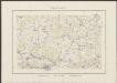
Meklenburg Ducatus. [Karte], in: Theatrum orbis terrarum, sive, Atlas novus, Bd. 1, S. 174.
1 Karte aus Atlas Blaeu, Joan Blaeu, Willem Janszoon
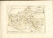
Maklenburg Ducatus

Die Grosshezogthümer Meklenburg-Schwerin und Meklenburg-Strelitz
1 : 370000 Meklenbursko (Německo) Gräf, C. Luther, Th. Geographisches Institut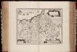
Meklenbvrg dvcatvs / auctore Ioanne Laurenbergio ; S. Rogiers sculp
1 : 450000 Annotatie: Origineel is Blad 84 in atlas factice; Annotatie geografische gegevens: Met 2 schaalstokken Salomon Rogiers ca 1592- v. 1640; Willem Jansz Blaeu 1571-1638 Amstelodami : Guiljelmus Blaeuw excudit
Meklenburg Ducatus [Karte], in: Novus atlas absolutissimus, Bd. 2, S. 39.
1 Karte aus Atlas Janssonius Offizin
Meklenburg Ducatus [Karte], in: Gerardi Mercatoris et I. Hondii Newer Atlas, oder, Grosses Weltbuch, Bd. 1, S. 280.
1 Karte aus Atlas Mercator, Gerhard und Hondius, Jodocus Jansson, Jan
Insvlae Danicae in Mari Balthico sitae utpote Zeelandia, Fionia, Langelandia, Lalandia, Falstria, Fembria Mona repraesentatae
1 : 470000 Baltské moře-oblast Homann, Johann Baptist J.B. Homann
Insvlae Danicae in mari Balthico sitae utpote Zeelandia, Fionia, Langelandia, Lalandia, Falstria, Fembria Mona
1 : 470000 Baltské moře-oblast Homann, Johann Baptist a Ioh. Bapt. Homanno
Meklenburg Ducatus. [Karte], in: Novus Atlas, das ist, Weltbeschreibung, Bd. 1, S. 96.
1 Karte aus Atlas Blaeu, Joan Blaeu, Willem Janszoon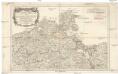
Nouvelle carte de la Pomeranie occidentale et de l'electorat de Brandebourg
1 : 790000 Braniborsko (Německo) Rizzi Zannoni, Giovanni Antonio Julien, Roch Joseph Julien