Maps of Łabiszyn

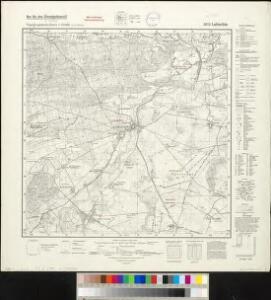
Meßtischblatt 3073 : Labischin, 1940
1 : 250000 Labischin. - Ausg. m. dt. Namen, Ausg. 1940 m. vorläuf. Namen. - 1:25000. - [Berlin]: Reichsamt für Landesaufnahme, 1940. - 1 Kt.
Composite: 253. Inowrazlaw.
1 : 100000 Reichsamt fur Landesaufnahme
253. Inowrazlaw.
1 : 100000 Reichsamt fur Landesaufnahme
81. Gnesen, uit: Topographische Uebersichtskarte des Deutschen Reiches / herausgegeben v. d. Kartogr. Abt. d. Königl. Preuß. Landesaufnahme
1 : 200000 titelvariant: Topogr. Übersichtskarte des Deutschen Reiches; Annotatie: Titel boven bladen ook: Topogr. Übersichtskarte des Deutschen Reiches; Annotatie geografische gegevens: Op elk blad twee maatstokken: 10 Kilometer = 5,5 cm; 1 geogr. Meile = 3,6 cm; Legenda onder op elk blad Königlich Preußische Landesaufnahme. Kartographische Abtheilung [S.l : Königlich Preußische Landesaufnahme, Kartographische Abtheilung]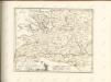

Sect. 10: Bromberg, uit: Geologische Karte des Deutschen Reichs in 27 Blaettern / [von] Richard Lepsius ; Red. von C. Vogel
1 : 500000 Annotatie: Blad 18 ontbreekt; Een aantal bladen op linnen; Een aantal bladen gereviseerd 1913-1914; Annotatie geografische gegevens: Met schaalstokken o.a. in kilometers; Legenda Carl Vogel 1828-1897 Gotha : Justus Perthes
Bromberg
1 : 600000 Opitz, Carl Solbrig
Monumenta Cartographica Bohemiae II.: Müllerova mapa

Provinz Posen
1 : 1200000 Provinz Posen
Posen.
1 : 810000 Radefeld, Carl Christian Franz, 1788-1874
Palatinatus Posnaniensis. In Majori Polonia Primarii Nova Delinatio [Karte], in: Novus atlas absolutissimus, Bd. 1, S. 96.
1 Karte aus Atlas Janssonius Offizin
Languages in Prussian Poland
1 : 600000 First World War map of Languages in Prussian Poland. War Office
Provinz Posen
Grosser Hand-Atlas über alle Theile der Erde in 170 Karten Meyer, J. Verlag des Bibliographischen Instituts
Die polnische Curve in Westpreußen
Polen Westpreußen Polen Bevölkerung
Provinz Westpreussen
1 : 1250000 Westpreußen
Kreise der Provinz Posen 1864
Preußen, Provinz Posen, Verwaltungsgliederung Kunz, Andreas ; Moeschl, Joachim Robert
PALATINATVS | POSNANIENSIS, | IN MAIORI POLONIA PRIMARII
NOVA DELINEATIO | Per G.F.M. Gerard Coeck sculpsit. Amsterdami | Exc. Joannes Blaeu.
Silesia Inferior. [Karte], in: Theatrum orbis terrarum, sive, Atlas novus, Bd. 1, S. 144.
1 Karte aus Atlas Blaeu, Joan Blaeu, Willem Janszoon
Provinz Westpreussen
1 : 472000 Gdaňsk (Polsko) Handtke, Friedrich Carl Flemming
Danzig, Colberg, Thorn
1 : 750000 Gdaňsk (Polsko : oblast) Konrad, A. K. u. k. Militärgeographisches Institut
Danzig, Colberg, Thorn
1 : 750000 Gdaňsk (Polsko : oblast) K. k. militär-geographisches Institut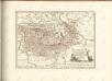

Kolonie założone za panowania Fryderyka Wielkiego w Prusach Królewskich i w obwodzie nadnoteckim
Polen Ostpreußen Netzedistrikt Stadtgründung Friedrich II.
Posen.
1 : 945000 Flemming, Carl

Belgicarum XVII Provinciarum Tabula
1 : 875000 Mollova mapová sbírka Danckerts, Justus Danckerts, Justus

West Preussen.
1 : 940000 Flemming, Carl