Maps of Getelo

Meßtischblatt 1868 : Getelomoor, 1896
1 : 250000 Getelomoor. - Aufn. 1895, hrsg. 1896. - 1:25000. - [Berlin]: Reichsamt für Landesaufnahme, 1896. - 1 Kt.
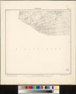
280. Getelomoor.
1 : 100000 Reichsamt fur Landesaufnahme
28 Almelo, uit: Topographische en militaire kaart van het Koningrijk der Nederlanden / vervaardigd door de officieren van den Generale Staf ; en gegraveerd op het Topographisch Bureau, van het Ministerie van Oorlog
1 : 50000 titelvariant: TMK; Annotatie: Met bladwijzer op schaal 1:600.000. - 1915; Met Verklaring van de topographische en militaire kaart van het Koninkrijk der Nederlanden. - 1910; Bd. 1: titelblad, bladwijzer, verklaring, bladen 1 t/m 32; Bd. 2: bladen 33 t/m 62 Generale Staf, Nederland; Ministerie van Oorlog. Topographisch Bureau ['s-Gravenhage : Ministerie van Oorlog]
Composite: 280. Getelomoor.
1 : 100000 Reichsamt fur Landesaufnahme

12me Koeverden, uit: Nouvelle carte de la Hollande, d'après Kraijenhoff et les meilleures cartes connues / Établissement Géographique de Bruxelles, fondé par Ph. Vander Maelen
1 : 117000 Annotatie: De bladen zijn genummerd 1-24. De bladen 2 t/m 24 hebben elk een afzonderlijke titel. Blad 5 bevat: Triangulations et positions. Blad 9 bevat: Plan d'Amsterdam; De kaartbladen 1, 5, 9 en 24 zijn niet ingekleurd; Van kaartblad 24 is een extra (ingekleurd) exempl. aanwezig; Annotatie geografische gegevens: 2 schaalstokken: 5 Echelle de 5 lieues de 20 au degré ... (= 23,2 cm) en 7380 Echelle de 5 lieues de 20 au degré ... (= 23,2 cm); Legenda; Met indexkaart: Carte d'assemblage Philippe Marie Guillaume Vander Maelen 1795-1869; Établissement Géographique de Bruxelles Bruxelles : Établissement Géographique
[Kaart], uit: Kaart van de rijwielpaden, wandelwegen en ruiterwegen in Twenthe en Salland
1 : 100000 's-Gravenhage [etc.] : A.N.W.B., Toeristenbond voor Nederland
83. Bentheim, uit: Topographische Uebersichtskarte des Deutschen Reiches / herausgegeben v. d. Kartogr. Abt. d. Königl. Preuß. Landesaufnahme
1 : 200000 titelvariant: Topogr. Übersichtskarte des Deutschen Reiches; Annotatie: Titel boven bladen ook: Topogr. Übersichtskarte des Deutschen Reiches; Annotatie geografische gegevens: Op elk blad twee maatstokken: 10 Kilometer = 5,5 cm; 1 geogr. Meile = 3,6 cm; Legenda onder op elk blad Königlich Preußische Landesaufnahme. Kartographische Abtheilung [S.l : Königlich Preußische Landesaufnahme, Kartographische Abtheilung]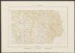
Comitatus Bentheim, et Steinfurt. [Karte], in: Theatrum orbis terrarum, sive, Atlas novus, Bd. 1, S. 212.
1 Karte aus Atlas Blaeu, Joan Blaeu, Willem Janszoon
Comitatus Bentheim, et Steinfurt. [Karte], in: Novus Atlas, das ist, Weltbeschreibung, Bd. 1, S. 132.
1 Karte aus Atlas Blaeu, Joan Blaeu, Willem Janszoon
Comitatus Bentheim, et Steinfurt. [Karte], in: Novus atlas absolutissimus, Bd. 2, S. 121.
1 Karte aus Atlas Janssonius Offizin
Comitatus Bentheim, et Steinfurt. [Karte], in: Le théâtre du monde, ou, Nouvel atlas contenant les chartes et descriptions de tous les païs de la terre, Bd. 1, S. 163.
1 Karte aus Atlas Blaeu, Willem Janszoon und Blaeu, Joan Blaeu, Willem Janszoon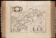
Comitatus Bentheim, et Steinfurt / auctore Ioanne Westenberg ; [Willem Jansz. Blaeu]
1 : 230000 Annotatie: Het eerst verschenen in: Ander Theil Novi Atlantis ... - Amsterdami : apud Guiljelmum et Johannem Blaeu, 1635; Origineel is Blad 78 in atlas factice; Annotatie geografische gegevens: Oost boven Westenberg, Johannes; Blaeu, Willem Jansz. [Amsterdam : Guljelm. Blaeu excudebat]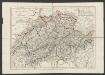
Comitatus Bentheimensis Nova Descriptio [Karte], in: Gerardi Mercatoris et I. Hondii Newer Atlas, oder, Grosses Weltbuch, Bd. 1, S. 173.
1 Karte aus Atlas Mercator, Gerhard und Hondius, Jodocus Jansson, Jan
Comitatus Zutphaniae
1 : 180000 Mollova mapová sbírka Wit, Frederik de Covens, Johannes I
Novissima Comitatus Zutphaniae, Totiusque Fluminis Isulae Descriptio
1 : 190000 Mollova mapová sbírka Visscher, Nicolaes Schenk, Peter II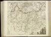
[95][96] Comitatus Zutphaniae et fluminis insulae nova, uit: Atlas sive Descriptio terrarum orbis
Annotatie: Gedigitaliseerde versie. Amsterdam. Heiloo : Picturae (vervaardiger), 2015. tiff-bestand. Gedigitaliseerd: 07-01-2015; Origineel: Universiteitsbibliotheek Vrije Universiteit (XL.05127.-) ; Netherlands; Titelpagina ontbreekt Wit, Frederik de Amsterdam : Frederick de Wit
Novissima Comitatus Zutphaniae totiusque fluminis Isulae descriptio
1 : 190000 per Nic. Visscher. [Amsterdam : Nicolaus Visscher]
Kaart der Provincie Overijssel, afgedeeld in III administratieve kwartieren
1 : 240000 gegraveerd door Hs. en Dl. Veelwaard Junior. Te Amsterdam : bij Mortier, Covens & Zoon
Comitatus Zutphaniae sive Geldriae Tetrachiae Zutphaniensis Isalaeque fluvii correctissima descriptio
1 : 170000 de novo revisa, accurate divisa et edita per F. de Witt Amstelodami. Amstelodami : apud I. Covens et C. Mortier
Novissima Comitatus Zutphaniae totiusque fluminis Isulae descriptio
1 : 190000 per Nic. Visscher. [Amsterdam : Nicolaus Visscher]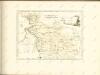

Bijlage 6, uit: Eindverslag over de onderzoekingen en uitkomsten van den Dienst der Rijksopsporing van Delfstoffen in Nederland, 1903-1916
Annotatie: Met lit. opg Departement van Landbouw, Nijverheid en Handel. Dienst der Rijksopsporing van Delfstoffen ['s-Gravenhage : Martinus Nijhoff]
Transisalania Provincia Vulgo Over-Yssel
1 : 200000 Mollova mapová sbírka Have, Nicholas ten Covens, Johannes I
Transisalania Vulgo Over-Yssel
1 : 190000 Mollova mapová sbírka Have, Nicholas ten Ottens, Josua
Overijssel, uit: Sterfte-atlas van Nederland over 1860-1874 / [uitgave van de Nederlandsche Maatschappij tot Bevordering der Geneeskunst]
titelvariant: Sterfte-atlas van Nederland; Annotatie: Alleen kaartbijlage aanwezig Pieter Harmen Witkamp 1816-1892; Nederlandsche Maatschappij tot Bevordering der Geneeskunst Amsterdam : van Rossen
Transisalania provincia vulgo Over-Yssel
1 : 200000 Have, Nicolaas ten Wit, Frederick de F. de Wit
TRANSISALANIA PROVINCIA Vulgo Over-Yssel
1 : 200000 Have, Nicholas ten Visscher, Claes Jansz. C.I. Visscher excudit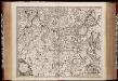
Novissima Comitatus Zutphaniae totiusq fluminis Isulae descriptio / [Nicolaes Visscher]
1 : 193000 Annotatie: Origineel is Blad 59 in atlas factice; Annotatie geografische gegevens: West boven Visscher, Nicolaes (1649-1702) [Amsterdam : ex officina Nicolai Visscher]