Maps of Klettbach

Meßtischblatt 2933, neue Nr. 5032 : Erfurt, 1936
1 : 250000 Erfurt. - Hrsg. 1905, bericht. 1922, Nachtr. 1936. - 1:25000. - [Berlin]: Reichsamt für Landesaufnahme, 1936. - 1 Kt.
Meßtischblatt 2933 : Erfurt, 1918
1 : 250000 Erfurt. - Aufn. 1903, hrsg. 1905, Aufldr. 1918. - 1:25000. - [Berlin]: Reichsamt für Landesaufnahme, 1918. - 1 Kt.
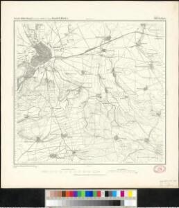
Meßtischblatt 2933 : Erfurt, 1905
1 : 250000 Erfurt. - Aufn. 1903. - 1:25000. - [Berlin]: Reichsamt für Landesaufnahme, 1905. - 1 Kt.
Meßtischblatt 2933 : Erfurt, 1878
1 : 250000 Erfurt. - Aufn. 1853, hrsg. 1873, bericht. 1878. - 1:25000. - [Berlin]: Reichsamt für Landesaufnahme, 1878. - 1 Kt.
Preussische Provinz Sachsen
Grosser Hand-Atlas über alle Theile der Erde in 170 Karten Meyer, J. Verlag des Bibliographischen Instituts
Celeberrima ac spatiosißima Thuringiae metropolis Erfurtum
Erfurt (Německo) Koenig, Erhard Georg Seutter, Matthäus Matthaeus Seutter
Plan de la ville d'Erfordt, capitale de la Thuringe
Erfurt (Německo) Oebschelwitz, L. W. von Hondt, Pierre de chez Pierre de Hondt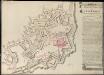
Plan De La Forteresse De Petersberg
Freis, Charles; Hill, Johann Jakob
Plan de la Ville d'Erford. Capitale de la Thuringe, avec ses deux Citadelles St. Petersberg & Cyriacusberg
1 : 6000 Mollova mapová sbírka Oebschelwitz, L. W. von Hondt, Pierre de
Nova teritorii Erfordien in suas praefecturas accurate divisi descriptio
1 : 90000 Durynsko (Německo) Homann, Johann Baptist Zollmann, Friedrich J.B. Homann
Nova teritorii Erfordien in suas praefecturas
1 : 90000 Durynsko (Německo) Homann, Johann Baptist J. B. Homann

Nova Territori[i] Erfordien[sis] in Suas Praefecturas accurate divisi descriptio cui accedit Erfordiae Urbis exterior Facies et Prospectus
1 : 90000 Mollova mapová sbírka Homann, Johann Baptist Homann, Johann Baptista
127. Gotha, uit: Topographische Uebersichtskarte des Deutschen Reiches / herausgegeben v. d. Kartogr. Abt. d. Königl. Preuß. Landesaufnahme
1 : 200000 titelvariant: Topogr. Übersichtskarte des Deutschen Reiches; Annotatie: Titel boven bladen ook: Topogr. Übersichtskarte des Deutschen Reiches; Annotatie geografische gegevens: Op elk blad twee maatstokken: 10 Kilometer = 5,5 cm; 1 geogr. Meile = 3,6 cm; Legenda onder op elk blad Königlich Preußische Landesaufnahme. Kartographische Abtheilung [S.l : Königlich Preußische Landesaufnahme, Kartographische Abtheilung]
Gotha Herzogthum.
1 : 200000 Meyer, Joseph, 1796-1856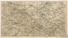
Der Thüringerwald

Geognostische Karte des Thüringer Waldes. Nordwestliche Hälfte
1 : 200000 Geognostische Karte des Thüringer Waldes Credner, Heinrich Justus Perthes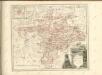

Geognostische Uebersichtskarte des Thüringer Waldes
1 : 100000 Beyschlag, Franz ; Pütz, M. Simon Schropp
[Neueste Karte vom Herzogth: Gotha und angränzend: Ländern]
Grosser Hand-Atlas über alle Theile der Erde in 170 Karten Meyer, J. Verlag des Bibliographischen Instituts
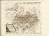
Regiae Celsitudini Serenissimo Principi ac Domino Friderico Christiano Leopoldo
1 : 200000 Mollova mapová sbírka Zollmann, Johann Wilhelm Oetinger, Christ. Friedrich Homann, Johann Baptista - dědici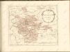

Erfurt
1 : 300000 R. Mittelbach
Fürstentum Schwarzburg-Rudolstadt 1823 Verwaltungsstruktur
Schwarzburg-Rudolstadt Verwaltung Kunz, Andreas ; Moeschl, Joachim Robert
Fürstentum Schwarzburg-Rudolstadt 1820 Verwaltungsstruktur
Schwarzburg-Rudolstadt Verwaltung Kunz, Andreas ; Moeschl, Joachim Robert
Erfurt 87, uit: Special-Karte von Mittel-Europa / nach amtlichen Quellen bearbeitet von W. Liebenow
1 : 300000 titelvariant: W. Liebenow's Mittel-Europa; Annotatie: Titel boven de bladen: W. Liebenow's Mittel-Europa Johannes Wilhelm Liebenow 1822-1897 Frankfurt a. M. : Ludwig Ravenstein
Fürstentum Schwarzburg-Sondershausen 1820 Verwaltungsstruktur
Schwarzburg-Sondershausen Verwaltung Kunz, Andreas ; Moeschl, Joachim Robert
Tvringiae noviss. descript
1 Karte : Kupferdruck ; 28 x 20 cm Mellinger; Ortelius s.n.