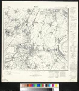
Maps of Brühl

Meßtischblatt 2971 : Brühl, 1936
1 : 250000 Brühl. - Hrsg. 1895, bericht. 1926, einz. Nachtr. 1933. - 1:25000. - [Berlin]: Reichsamt für Landesaufnahme, [19]36. - 1 Kt.
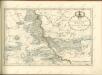
DESCRIPTIO AGRI | CIVITATIS COLONIENSIS, | Cum suis limitibus, terminis, viis, confiniis, interjacen- | tibus et adjacentibus Pagis, Villis, Castris, etc.
[Amsterdam : Joan Blaeu]
Descriptio agri civitatis Coloniensis : cum suis limitibus, terminis, viis, confiniis, interjacentibus, et adjacentibus pagis, villis, castris etc
1 : 60000 Cóvens et Mortier apud I. Cóvens et C. Mortier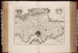
Descriptio agri civitatis Coloniensis : cum suis limitibus, terminis, viis, confiniis, interjacentibus et adjacentibus pagis, villis, castris, etc. / [Joan Blaeu]
1 : 25000 Annotatie: Het eerst verschenen in: Atlas maior, sive Cosmographia Blaviana ... - Amstelaedami : sumptibus Ioannis Blaeu, 1662; Origineel is Blad 72 in atlas factice; Annotatie geografische gegevens: West boven Blaeu, Joan [Amsterdam : Joan Blaeu]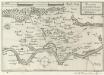
Accurata Territorii Coloniensis Descriptio
Mollova mapová sbírka Person, Nikolaus Person, Nicolas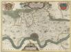
Descriptio Agri Civitatis Coloniensis
1 : 55000 Mollova mapová sbírka Blaeu, Joan Mortier, Pierre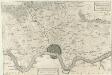
Descritione del distretto della Citta di Colonia con li suoi termini Confini, Villaggi, e Terre &
1 : 55000 Mollova mapová sbírka Hacque, Johann Baptist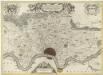
Descriptio Agri Civitatis Coloniensis
1 : 55000 Mollova mapová sbírka Blaeu, Joan Blaeu, Joan I.
Plan von Coeln u. Umgegend
1 : 25000 Roos Lengfeld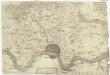
Descritione' del dis[tretto] della citta' di Colo[nia] con li suoi termi[ni] confini, villagi e terr[e &]
1 : 100000 Kolín nad Rýnem-oblast (Německo)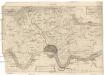
Descritione' del distretto della citta' di Colonia con li suoi termini confini, villagi e terre &
1 : 100000 Kolín nad Rýnem-oblast (Německo)
Cöln : [sheet] 2908
1 : 25000 Prussia (Germany). Landesaufnahme Konig[liche] Preuss[ische] Landes-Aufnahme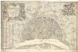
Nova et accurata ichnographia liberae ac imperialis civitatis Coloniensis anno 1752 confecta et ejusdem civitatis perillustribus strenuls consultis simisque dominis d[omi]nis consultibus et senatui
1 : 3800 Kolín nad Rýnem (Německo) Reinhardt, J. V. Rößler, Michael
Town plan of Köln (1944)
Germany. Town Plan of Köln--Cologne. Second edition. Key to street names and numbered buildings on reverse. Scale 1 : 12,500. [G.S.G.S. No. 4480]
Uebersichtsplan zur Banordnung für den Stadtkreis Cöln
1 : 15000 Gross, Wilh Wilh. Gross
Plan von Koln und Umgebung
1 : 12000 Greven's Kölner Adressbuch Verlag F. A. Brockhaus' Georg.-artist
[20] Sect. Cöln, uit: Geologische Karte der Rheinprovinz und der Provinz Westphalen / ausgeführt durch H. von Dechen
1 : 80000 titelvariant: Dechen's geologische Karte vom Rheinland und Westphalen; Annotatie: Titel op bladoverzicht; Incompleet Heinrich von Dechen Berlin : Schropp
123. Cöln a. Rh., uit: Topographische Uebersichtskarte des Deutschen Reiches / herausgegeben v. d. Kartogr. Abt. d. Königl. Preuß. Landesaufnahme
1 : 200000 titelvariant: Topogr. Übersichtskarte des Deutschen Reiches; Annotatie: Titel boven bladen ook: Topogr. Übersichtskarte des Deutschen Reiches; Annotatie geografische gegevens: Op elk blad twee maatstokken: 10 Kilometer = 5,5 cm; 1 geogr. Meile = 3,6 cm; Legenda onder op elk blad Königlich Preußische Landesaufnahme. Kartographische Abtheilung [S.l : Königlich Preußische Landesaufnahme, Kartographische Abtheilung]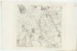
X ; 2.M., uit: Carte chorographique des Pays-Bas Autrichiens / ... par le Comte de Ferraris ; gravée par L.A. Dupuis
1 : 86400 Annotatie: Bladen linksboven genummerd met Romeinse cijfers, rechtsboven met een cijfer en een letter; Met opdracht aan keizer Joseph II (bl.XVI); Met plattegrond van Brussel (bl. XXI), overzichtskaart (bl. XXII) en bladwijzer (bl. XXIII); Annotatie geografische gegevens: Schaalstokken: Echelle de Toises ou de Lieues communes de France; Echelle de Verges ou de Lieues de Brabant; Echelle de Milles d'Allemagne (bl. XVII); Echelle de Mètres; In de hoeken lengte- en breedtematen T.M.e en T.P.e Joseph-Jean François Ferraris Comte de 1726-1814; L.A. Dupuis [S.l. : s.n.]
X, uit: Carte chorographique des Pays-Bas Autrichiens / ... par le Comte de Ferraris ; gravée par L.A. Dupuis
1 : 86400 Annotatie: Lit.: Les militaires et la cartographie des Pays-Bas méridionaux et de la Principauté de Liège à la fin du XVIIe et au XVIII siècle / Claire Lemoine-Isabeau. - Bruxelles, 1984, p. 206-212; La cartographie au XVIIIe siècle et l'oeuvre du Comte de Ferraris (1726-1814) : colloque international, Spa, 8-11 sept. 1976. - Bruxelles, 1978; Met opdracht aan keizer Joseph II (bl.XVI); Met plattegrond van Brussel (bl. XXI), overzichtskaart (bl. XXII) en bladwijzer (bl. XXIII); Ontbreekt: bl. I-III en XXI; Voor aanwezige bladen zie overzichtsblad Ferraris, Johann Joseph; Dupuis, L. A. [S.l. : s.n.]
84. North Rhine-Westphalia. The World Atlas.
1 : 250000 USSR (Union of Soviet Socialist Republics).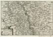
Bonn und Cöln.
1 : 300000 Mollova mapová sbírka Person, Nikolaus Person, Nicolas
Coloniensis archiepiscopatus
1 : 350000 Kolín nad Rýnem-oblast (Německo) Hondius, Henricus apud Henricum Hondium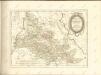

Carte Nouvelle de la Haute Partie de l'Archevesché et Eslectorat de Cologne Avec ses Enclaves dans les Pays Circomvoisins.
1 : 170000 Mollova mapová sbírka Sanson, Guillaume Ottens, Josua
Le Duché de Berg, le Comté de Homberg, les Seugneries de Hardenberg, et de Wildenborg
1 : 230000 Mollova mapová sbírka Sanson, Guillaume Covens, Johannes I
Le Duché de Berg, le Comté de Homberg, les Seugneries de Hardenberg, et de Wildenborg
1 : 230000 Mollova mapová sbírka Sanson, Guillaume Jaillot, Alexis Hubert
Archiepiscopatus Coloniensis Pars Australis
1 : 260000 Mollova mapová sbírka Gigas, Johann Michael
Archiepiscopatus Coloniensis Pars Australis
1 : 260000 Mollova mapová sbírka Gigas, Johann Michael