Maps of Amt Wachsenburg

Meßtischblatt 2996 : Marlishausen, [nach 1945]
1 : 250000 Marlishausen. - [Aufn. 1903], Druckvermerk [19]36. - 1:25000. - [Berlin]: Reichsamt für Landesaufnahme, [nach 1945]. - 1 Kt.
Meßtischblatt 2995, neue Nr. 5131 : Arnstadt, 1936
1 : 250000 Arnstadt. - Hrsg. 1905, bericht. 1926, einz. Nachtr. 1936. - 1:25000. - [Berlin]: Reichsamt für Landesaufnahme, 1936. - 1 Kt.
Meßtischblatt 2995 : Arnstadt, 1920
1 : 250000 Arnstadt. - Aufn. 1903, bericht. 1920. - 1:25000. - [Berlin]: Reichsamt für Landesaufnahme, 1920. - 1 Kt.
Nova Territori[i] Erfordien[sis] in Suas Praefecturas accurate divisi descriptio cui accedit Erfordiae Urbis exterior Facies et Prospectus
1 : 90000 Mollova mapová sbírka Homann, Johann Baptist Homann, Johann Baptista

[Recto], uit: Geognostische Übersichtskarte des Thüringer Waldes / F. Beyschlag
1 : 100000 Annotatie: Omslagtitel Franz Heinrich August Beyschlag 1856-1915 [S.l. : s.n.]
127. Gotha, uit: Topographische Uebersichtskarte des Deutschen Reiches / herausgegeben v. d. Kartogr. Abt. d. Königl. Preuß. Landesaufnahme
1 : 200000 titelvariant: Topogr. Übersichtskarte des Deutschen Reiches; Annotatie: Titel boven bladen ook: Topogr. Übersichtskarte des Deutschen Reiches; Annotatie geografische gegevens: Op elk blad twee maatstokken: 10 Kilometer = 5,5 cm; 1 geogr. Meile = 3,6 cm; Legenda onder op elk blad Königlich Preußische Landesaufnahme. Kartographische Abtheilung [S.l : Königlich Preußische Landesaufnahme, Kartographische Abtheilung]
Gotha Herzogthum.
1 : 200000 Meyer, Joseph, 1796-1856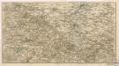
Der Thüringerwald

Geognostische Karte des Thüringer Waldes. Nordwestliche Hälfte
1 : 200000 Geognostische Karte des Thüringer Waldes Credner, Heinrich Justus Perthes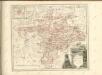

Geognostische Uebersichtskarte des Thüringer Waldes
1 : 100000 Beyschlag, Franz ; Pütz, M. Simon Schropp
[Neueste Karte vom Herzogth: Gotha und angränzend: Ländern]
Grosser Hand-Atlas über alle Theile der Erde in 170 Karten Meyer, J. Verlag des Bibliographischen Instituts
Regiae Celsitudini Serenissimo Principi ac Domino Friderico Christiano Leopoldo
1 : 200000 Mollova mapová sbírka Zollmann, Johann Wilhelm Oetinger, Christ. Friedrich Homann, Johann Baptista - dědici
Herzogtum Sachsen-Meiningen 1820 Verwaltungsstruktur
Sachsen-Meiningen Verwaltung Kunz, Andreas ; Moeschl, Joachim Robert

Erfurt
1 : 300000 R. Mittelbach
Principatus Hennenbergensis
1 : 300000 Mollova mapová sbírka Hondius, Henricus Schenk, Peter I
Principatus Hennenbergensis
1 : 300000 Mollova mapová sbírka Hondius, Henricus Janssonius, Johannes I
Fürstentum Schwarzburg-Rudolstadt 1823 Verwaltungsstruktur
Schwarzburg-Rudolstadt Verwaltung Kunz, Andreas ; Moeschl, Joachim Robert
Fürstentum Schwarzburg-Rudolstadt 1820 Verwaltungsstruktur
Schwarzburg-Rudolstadt Verwaltung Kunz, Andreas ; Moeschl, Joachim Robert
Erfurt 87, uit: Special-Karte von Mittel-Europa / nach amtlichen Quellen bearbeitet von W. Liebenow
1 : 300000 titelvariant: W. Liebenow's Mittel-Europa; Annotatie: Titel boven de bladen: W. Liebenow's Mittel-Europa Johannes Wilhelm Liebenow 1822-1897 Frankfurt a. M. : Ludwig Ravenstein
Fürstentum Schwarzburg-Sondershausen 1820 Verwaltungsstruktur
Schwarzburg-Sondershausen Verwaltung Kunz, Andreas ; Moeschl, Joachim Robert
Tvringiae noviss. descript
1 Karte : Kupferdruck ; 28 x 20 cm Mellinger; Ortelius s.n.
Tvringiae noviss. descript
1 Karte : Kupferdruck ; 28 x 20 cm Mellinger; Ortelius s.n.
Principatus Isenacensis
1 : 210000 Mollova mapová sbírka Homann, Johann Baptist Homann, Johann Baptista
COMITATVS | HENNEBER- | GENSIS.
[Amsterdam : Joan Blaeu]
Special Charte von dem Thüringer Walde
Durynský les (Německo) von dem Geographischen Institute
Carte pour Servir de Suite à la Partie Meridionale du Landgraviat de Hesse-Cassel avec les pays voisins de la Thüringe
1 : 200000 Mollova mapová sbírka Brönner, Heinrich Ludwig Broenner, Heinrich Ludwig
![Meßtischblatt 2996 : Marlishausen, [nach 1945]](https://images-2.georeferencer.com/images/iiif/271703478476/full/,300/0/native.jpg)

