Maps of Murcki

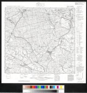
Meßtischblatt 5880 : Lendzin, 1931
1 : 250000 Lendzin. - Aufn. 1881, hrsg. 1883, Nachtr. 1931. - 1:25000. - [Berlin]: Reichsamt für Landesaufnahme, 1931. - 1 Kt.
Myslowitz und Oświecim
1 : 75000 Bloschitz, R. K. u. k. militär-geographisches Institut
Myslowitz und Oswiecim.
from Spezialkarte der osterreichisch-ungarischen Monarchie.
147. Beuthen, uit: Topographische Uebersichtskarte des Deutschen Reiches / herausgegeben v. d. Kartogr. Abt. d. Königl. Preuß. Landesaufnahme
1 : 200000 titelvariant: Topogr. Übersichtskarte des Deutschen Reiches; Annotatie: Titel boven bladen ook: Topogr. Übersichtskarte des Deutschen Reiches; Annotatie geografische gegevens: Op elk blad twee maatstokken: 10 Kilometer = 5,5 cm; 1 geogr. Meile = 3,6 cm; Legenda onder op elk blad Königlich Preußische Landesaufnahme. Kartographische Abtheilung [S.l : Königlich Preußische Landesaufnahme, Kartographische Abtheilung]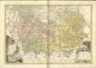

Ducatus Oswieczensis, Et Zatoriensis, Descriptio. [Karte], in: Theatrum orbis terrarum, S. 280.
1 Karte aus Atlas Ortelius, Abraham
Sbírka map a diagramů použitých na mírových konferencích v Paříži v letech 1919 - 1920
Carte ethnographique de la région de Ratiboř
Ratiboř (Polsko : oblast) Service cartographique de l'Armée Tchécoslovaque

Karta przeglądowa polskiego zagłębia węglowego
1 : 300000 Polsko Sarjusz-Makowski, Arnold
Das Fürstenthum Teschen in Ober-Schlesien
1 : 1170000 Těšínské Slezsko Schleuen, Johann David Schleuen
Silesie de Teschen 1913
Cieszyn-oblast (Polsko) Čs. voj. zeměpis. ústav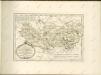

Bielitz 106, uit: Special-Karte von Mittel-Europa / nach amtlichen Quellen bearbeitet von W. Liebenow
1 : 300000 titelvariant: W. Liebenow's Mittel-Europa; Annotatie: Titel boven de bladen: W. Liebenow's Mittel-Europa Johannes Wilhelm Liebenow 1822-1897 Frankfurt a. M. : Ludwig Ravenstein
Beuthen 92, uit: Special-Karte von Mittel-Europa / nach amtlichen Quellen bearbeitet von W. Liebenow
1 : 300000 titelvariant: W. Liebenow's Mittel-Europa; Annotatie: Titel boven de bladen: W. Liebenow's Mittel-Europa Johannes Wilhelm Liebenow 1822-1897 Frankfurt a. M. : Ludwig Ravenstein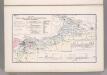
Coal Fields No. 8, Austria. Coal Resources of the World.
1 : 344800 Petrascheck, W.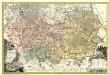
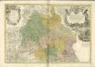
Principatvs Silesiae Rattiboriensis nova et exactissima Tabula geographica commonstrans insimul Liberas Dynastias Ples et Bevthen, cum Statu minore Loslav.
1 : 108000 Mollova mapová sbírka Wieland, Johann Wolfgang Homann, Johann Baptista - dědici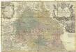
Principatvs Silesiae Oppoliensis
1 : 218000 Opolsko (Polsko) Wieland, Johann Wolfgang Homannianis Heredibus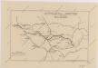
Sbírka map a diagramů použitých na mírových konferencích v Paříži v letech 1919 - 1920

[Rechterblad], uit: Podrobná mapa Vysokých Tater
1 : 25000 Annotatie: Opname 1896/97, gedeeltelijk herzien 1931; Annotatie geografische gegevens: Inzet: Pérehled oblasti Tater. - 1:200.000 [Praag : Vojenský Zeméepisný Ústav]
Silésie de Teschen
1 : 200000 Cieszyn-oblast (Polsko) Čs. voj. zeměpis. ústav
Silésie de Teschen
Cieszyn-oblast (Polsko) Čs. voj. zeměpis. ústav
Silésie de Teschen
Cieszyn-oblast (Polsko) Čs. voj. zeměpis. ústav
Mapa země Moravské. S částmi pohraničnými Slezska, Čech, Rakous i Uher

Granica Polski na Śląsku górnym
1 : 600000 Polsko Instytut kartograficzny Atlas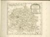

Kartographische Darstellung der Abstimmungs-Ergebnisse von Oberschlesien
1 : 100000 [im Auftrag des Auswärtigen Amtes bearb. in der Plankammer des Preußisch-Statistischen Landesamtes vom Gerke] ; mit Genehmigung der Landesaufnahme, Berlin Berlin : Berliner Lithographisches Institut
III. vojenské mapování 4061
1 : 75000