Maps of St. Leon-Rot

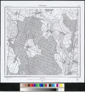
Meßtischblatt 40 : Wiesental, 1877
1 : 250000 Wiesental. - 1:25000. - Leipzig: Giesecke & Devrient, 1877. - 1 Kt.
Eigentlicher Plan des Feldlagers der Kayserlichen- und Reichs-Armee unter dem Com[m]ando des Printzens Evgenii vom 1sten bis 22 Julii A.o 1734 bey der von der frantzösischen Armee hart belagerten Festung Philippsbvrg nebst dem accuraten Plan des frantzösischens Retrenchements

173 Philipsbourg.
1 : 86400 Cassini family; Cassini, Cesar-Francois, 1714-1784
Vorstellung der Linie u[nd] Inondation von Bruchsahl bis Ketsch
1 : 60000 Mollova mapová sbírka Riecke, Gustav Friedrich Homann, Johann Baptista - dědici
[Philipsbourg]
1 Blatt : 60 x 91 cm s.n.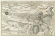
Die Gegend zwischen Landau, Speyer u. Philipsburg
1 : 100000 Mollova mapová sbírka Bodenehr, Gabriel Bodenehr, Gabriel
Grundris der Vestung Philippsburg nebst denen feindlichen Attaquen, Circumvalations-Linien u. Batterien aus welchen die Französische Armee den 23. May. 1734 die Vestung zu belagern, und den 7. Juny, selbige zu beschiessen angefangen und nach tapferer [...]
1 : 20000 auf das accurateste vorgestellet von einem berühmten Ingenieur L. S. C.
Plan der Kayserlichen und Reichs Vöstung Philippsburg
1 : 35000 Mollova mapová sbírka Duchaffat, Antoine
Plan de Philipsbourg & de ses environs assiegez par les troupes de France
1 : 10000 J. van Sassen fecit A Amsterdam : chez Reinier et Josué Ottens
Carte über den Lauf des Rheins von Lauterburg bis unterhalb Sandhofen längs der Badisch - Bayerschen Grenze

Carte über den Lauf des Rheins von Lauterburg bis unterhalb Sandhofen längs der Badisch - Bayerschen Grenze

Accurate Vorstellung und Merck würdige Belagerung der Reichs Festung Philippsburg
1 : 25000 Mollova mapová sbírka Seutter, Matthäus Seutter, Matthäus
Plan der R. Vestung Philipsburg
Mollova mapová sbírka Homann, Johann Baptista - dědici
Eigentlicher Plan des Feldlagers der Kayserlichen- und Reichs-Armee unter dem Commando des Printzens Eugenii vom 1sten bis 22 Julii Ao. 1734 bey der von der Frantzösischen Armee hart belagerten Festung, Philippsburg
1 : 30000 Mollova mapová sbírka Evžen Savojský
Philippoburgum
Mollova mapová sbírka Seutter, Matthäus Seutter, Matthäus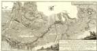
Carte von Linie und Innondation, von Bruchsal bis Kethsch, woselbst die Innondation in Rhein fließet.
1 : 65000 Mollova mapová sbírka Riecke, Gustav Friedrich Bodenehr, Gabriel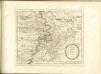
Accurate Special-Charte der Gegend des Rheins, von Ettlingen, Carls Ruhe, Philippsburg, Bruchsal, bis Mannheim, etc. Entworffen
Riecke, Gustav Friedrich; Ostertag, Heinrich Jonas; Cöntgen, Bartolomäus Anton Brönner
Carte Particuliere de Pays qui sont situéz entre le Rhein, la Saare, la Moselle, et la Basse Alsace
1 : 150000 Mollova mapová sbírka Jaillot, Alexis-Hubert Jaillot, Alexis Hubert
Exact und Gantz accurater Plan
1 : 570000 Mollova mapová sbírka Geyer, Friedrich W. Berndt, Johann Christoph Geyer, Friedrich
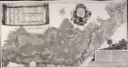
Suevia Universa
1 : 170000 Mollova mapová sbírka Michal, Jacques de Seutter, Matthäus Seutter, Matthäus
Carlsruhe - Stuttgart
1 : 200000 Herder, Benjamin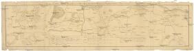
Camps et marches de l'armée imperiale com[m]andée par S.A.S. le prince de Savoye pour retourner de Wesenthal prés de Philippsbourg, et aller passer le Rhein a Mayence, l'armée de France étant campé a Oppenheim prés de céte ville
Mannheim (Německo) Müller, Johann Conrad
Territorium Seculare Episcopatvs Spirensis una cum terris adiacentibus
1 : 140000 Mollova mapová sbírka Blödtner, Cyriak Homann, Johann Baptista - dědici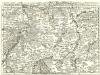
Staaten ahm Rhein, und Necker
1 : 180000 Mollova mapová sbírka Person, Nikolaus Person, Nicolas
Mannheim 113, uit: [W. Liebenow's Special-Karte von Mittel-Europa]
1 : 300000 titelvariant: W. Liebenow's Mittel-Europa; Annotatie: Titel boven de bladen: W. Liebenow's Mittel-Europa Johannes Wilhelm Liebenow 1822-1897 Hannover : Hermann Oppermann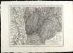
SpecialKarte von dem Odenwald, dem Bauland und einem Theil des Spessart's
1 : 216000 Haas, Johann Heinrich; Meister, G.; Felsing, Conrad

Suevia universa IX. tabulis delineata, 1
1 Blatt : s.n.