Maps of Bining

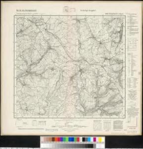
Meßtischblatt 6909 : Rohrbach b. Bitsch, 1942
1 : 250000 Rohrbach b. Bitsch. - Hrsg. 1883, Ausg. 1942 - 1:25000. - [Berlin]: Preußische Landesaufnahme, Hauptvermessungsabt. XI, 1942. - 1 Kt.
Le Flambeau de la Guerre Allumee au Rhin
Mollova mapová sbírka Delisle, Guillaume Schenk, Peter II
Le Flambeau de la Guerre Allumee au Rhin
Mollova mapová sbírka Delisle, Guillaume Schenk, Peter II
[Landau - Wissembourg]
1 Blatt : 60 x 90 cm Brunet s.n.

Carte Particuliere de Pays qui sont situéz entre le Rhein, la Saare, la Moselle, et la Basse Alsace
1 : 150000 Mollova mapová sbírka Jaillot, Alexis-Hubert Jaillot, Alexis Hubert
Partie Meridionale Des Pays Qui Sont Situéz Entre Le Rhein, La Saare, La Moselle Et La Basse Alsace
1 : 150000 Mollova mapová sbírka Mortier, Pieter Covens, Johannes I
Partie du Cours du Rhein, ou se Trouvent les Villes de Spire Philipsbourg Landau Hagenau et le Fort Louis, Dessigne et Levee sur les Lieues
1 : 160000 Mollova mapová sbírka Baillieul, Gaspard Bailleul, Gaspard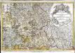
Le pays Messin, partie du temporel de l'evesché de Metz et partie du balliage allemand, dans le duché de Lorraine
1 Karte : Kupferdruck ; 44 x 68 cm Jaillot Alexis-Hubert Jaillot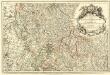
Les Estats du Duc de Lorraine ou sont les Duchez de Lorraine et de Bar :
1 : 180000 Mollova mapová sbírka Jaillot, Alexis-Hubert Jaillot, Alexis Hubert
Specialkarte Der Gegenden Zwischen Dem Rhein Und Der Saar
1 : 170000 Rheinwald, Johann Ludwig Christian; Dewarat, Peter; Walbert
Mediomatrici
1 Karte : Kupferdruck ; 43 x 50 cm Sanson chez l'auteur
Partie Meridionale Des Pays Qui Sont Situéz Entre Le Rhein, La Saare, La Moselle, Et La Basse Alsace. [Karte], in: Atlas nouveau, contenant toutes les parties du monde [...], Bd. 1, S. 241.
1 Karte aus Atlas Sanson, Nicolas Jaillot, Alexis Hubert und Mortier, Pieter
Alsatia tem Svperior, quam Inferior una cum Svndgovia
1 : 120000 Mollova mapová sbírka Homann, Johann Baptist Homann, Johann Baptista - dědici
Nancy 126, uit: [W. Liebenow's Special-Karte von Mittel-Europa]
1 : 300000 titelvariant: W. Liebenow's Mittel-Europa; Annotatie: Titel boven de bladen: W. Liebenow's Mittel-Europa Johannes Wilhelm Liebenow 1822-1897 Hannover : Hermann Oppermann
Archid.conné de Sarbovrg dans l'Evesché de Metz
1 : 240000 Mollova mapová sbírka Sanson, Nicolas Mariette, Pierre Sanson, Nicolas
Nancy 126, uit: Special-Karte von Mittel-Europa / nach amtlichen Quellen bearbeitet von W. Liebenow
1 : 300000 titelvariant: W. Liebenow's Mittel-Europa; Annotatie: Titel boven de bladen: W. Liebenow's Mittel-Europa Johannes Wilhelm Liebenow 1822-1897 Frankfurt a. M. : Ludwig Ravenstein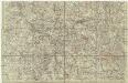
[Lotrinsko a Sársko]
Lotrinsko (Francie) Buna, Wilhelm C.
Alsatia inferior
1 Karte : Kupferdruck ; 35 x 42 cm Hondius; Mercator Jodocus Hondius
Le Theatre de Bellone :
Mollova mapová sbírka Schenk, Pieter Braakman, Adriaan
Carte topographique d'Allemagne
1 : 224000 Falc Rýnská Jaeger, Johann Wilhelm Abraham I. W. A. Iaeger
Mediomatrici
1 Karte : Kupferdruck ; 44 x 51 cm Sanson; Robert de Vaugondy chez l'auteur, chés le Sr. Robert geog. ord. du roi quai de l'horloge
Alsatia inferior
1 Karte : Kupferdruck ; 34 x 42 cm Mercator; Hondius excusum apud Henricum Hondium sub insigno atlantis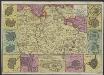
Carte du Duché de Lorraine, gravée sur les derniers memoires
1 : 600000 [Amsterdam] : [De La Feuille?]
Alsatia inferior
1 Karte : Kupferdruck ; 17 x 24 cm Mercator; Keere Cloppenburgh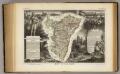
Dept. Du Bas Rhin.
1 : 455000 Levasseur, Victor.
Departement du Bas Rhin
1 Karte : Kupferdruck ; 16 x 15 cm au dépot de l'Atlas national rue de la Monnoye no. 5
Alsatia inferior
1 Karte : Kupferdruck ; 34 x 41 cm Mercator s.n.
[Atlas départemental : La France et ses colonies] No. 53 Meurthe
1 : 670000 publ. par Michel fils ainé [dressé par A. Lorrain, et gravé par H. Dandeleux] Versailles [etc.] : Barreswil et Andrieux