Maps of Vendenheim

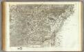
Meßtischblatt 3618 : Schiltigheim, 1913
1 : 250000 Schiltigheim. - Aufn. 1883, hrsg. 1885, gedr. [19]13. - 1:25000. - [Berlin]: Reichsamt für Landesaufnahme, 1913. - 1 Kt.
Meßtischblatt [7312] : Kinzigmündung, 1886
1 : 250000 Kinzigmündung. - 1:25000. - Leipzig: Giesecke & Devrient, 1886. - 1 Kt.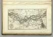
Map of the Course fo the Rhine, in the Environs of Strasbourg.
1 : 47000 Melish, John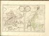

Plan de Strasbourg et ses environs
1 Plan : Kupferdruck ; 44 x 54 cm Cassini de Thury; Fietta; Fietta chez Fietta et Comp
Topographische - Carte des Rheinstromes und seiner beiderseitigen Ufer von Hüningen bis Lauterburg...

Blatt 13. Leutesheim, uit: Topographische Karte des Rheinstromes und seiner beiderseitigen Ufer von Hueningen bis Lauterburg oder längs der Französich-Badischen Gränze, ... / ... reducirt und gezeichnet ... im Bureau der Grossherzoglich Badischen Rheingränz-Berichtigungs Commission
1 : 20000 titelvariant: Rheingränz-Carte; Annotatie: Voor aanwezige bladen zie overzichtsblad Grossherzogliche Badische Rheingränz-Berichtigungs Commission. Bureau Freiburg im Breisgau : im Herder'schen Künst-Institut
[Štrasburg]
1 : 20000 Štrasburk (Francie)
Plan de Strasbourg
1 : 27000 Štrasburk (Francie) Crepy Crepy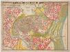
Plan der Stadt Strassburg : aufgestellt nach dem amtlichen Bebauungsplan
1 : 75000 Heinrich, W., publisher W. Heinrich
Strasbourg ville ancienne celebre et tres fortifieé [sic] du Roy. de France dans la Basse Alsace sur le Rhin = Strasburg eine Uhralte sehr Berühmte u. nun auch ungemein fortificirte Statt dem König in Franckr gehörig in Unter Elsas am Rhein ligend
1 : 11853 Seutter, Matthaeus, 1678-1756 M. Seutter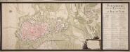
Strasbourg Avec Sa Citadelle Et Le Fort De Kehl
Steimmig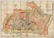
Bebauungsplan für die Erweiterung der Stadt Strassburg
1 : 5000 R. Schultz & cie Druck und Verlag R. Schultz & C[ie]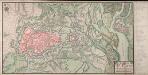
Plan De Strasbourg avec ses environs

Straatsburg, een vermaarde vestinge aan den Ill, by den Rhyn, in den Elsas aan de Fransse gekomen, den 30. Sept. 1681
Štrasburk (Francie) Schenk, Pieter P. Schenk
Le Flambeau de la Guerre Allumee au Rhin
Mollova mapová sbírka Delisle, Guillaume Schenk, Peter II
Territorium Argentoratense
1 : 625000 Štrasburk (Francie) Janssonius, Johannes Ioannes Iansonius
Territorium Argentoratense
1 : 600000 Štrasburk (Francie) Janssonius, Johannes Ioannes Iansonius
Chorographia Argentorati Alsatiae Metropolis
1 : 85000 Mollova mapová sbírka Seutter, Matthäus Seutter, Matthäus
Argentorati Territorium, vulgo Strasburger Gebiet Cum Maxima Episcopatus Cognominis, ac Occidentaliori Badensis Marchionatus Parte &c.
1 : 120000 Mollova mapová sbírka Allard, Carel Allard, Carel
Le cours du Rhin de Bâle à Hert près Philisbourg contenant l'Alsace et partie du Brisgau, 4
1 Blatt : 76 x 52 cm Le Rouge
Territorium Argentoratense
1 : 130000 Mollova mapová sbírka Valk, Gerhard Schenk, Pieter Schenk, Peter I
Territorium Argentoratense
1 : 130000 Mollova mapová sbírka Janssonius, Johannes Keere, Pieter van den Janssonius, Johannes I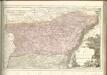
162 Strasbourg.
1 : 86400 Cassini family; Cassini, Cesar-Francois, 1714-1784
Chorographia Argentorati Alsatiæ metropolis
1 Karte : Kupferdruck ; 47 x 56 cm Seutter Matthäus Seutter
Argentorati territorium, vulgo Strasburger Gebiet
1 Karte : Kupferdruck ; 46 x 57 cm Allard by I. Cóvens et C. Mortier
169. Strassburg i. Elsass, uit: Topographische Uebersichtskarte des Deutschen Reiches / herausgegeben v. d. Kartogr. Abt. d. Königl. Preuß. Landesaufnahme
1 : 200000 titelvariant: Topogr. Übersichtskarte des Deutschen Reiches; Annotatie: Titel boven bladen ook: Topogr. Übersichtskarte des Deutschen Reiches; Annotatie geografische gegevens: Op elk blad twee maatstokken: 10 Kilometer = 5,5 cm; 1 geogr. Meile = 3,6 cm; Legenda onder op elk blad Königlich Preußische Landesaufnahme. Kartographische Abtheilung [S.l : Königlich Preußische Landesaufnahme, Kartographische Abtheilung]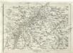
Geographica Provinciarum Sveviae Descriptio =
Mollova mapová sbírka Hurter, Johann Christoph Bodenehr, Johann Georg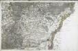
![Meßtischblatt [7312] : Kinzigmündung, 1886](https://images-2.georeferencer.com/images/iiif/506226564188/full/,300/0/native.jpg)

