Maps of Blaustein

Meßtischblatt [7525] : Bermaringen, 1926
1 : 250000 Bermaringen. - 1:25000. - Stuttgart, 1926. - 1 Kt.
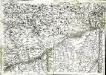
Meßtischblatt [7525] : Bermaringen, 1909
1 : 250000 Bermaringen. - 1:25000. - Stuttgart, 1909. - 1 Kt.
Abriss des Territorii Ulmensis Ultra-Danubialis, Sambt denen Beeden Wildpan. bezürcken
1 : 100000 Mollova mapová sbírka Mayer, Bartholomaeus Bodenehr, Gabriel
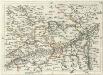
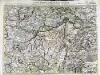
Accurater Grund-Riss sambt der Situation und Attaque des H. Röm. Reichs freyen und berühmten Stadt Ulm
Mollova mapová sbírka Bodenehr, Gabriel Bodenehr, Gabriel
Germany [Town plans of], Ulm
Town plans of Germany, GSGS 4480. Great Britain. War Office. [London] : War Office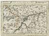
Ulm mit dero Gegend auf 2 Stund.
1 : 150000 Mollova mapová sbírka Bodenehr, Gabriel Bodenehr, Gabriel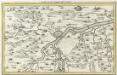
Ulm mit der Gegend auf 1 1/4 Stund
Mollova mapová sbírka Bodenehr, Gabriel Bodenehr, Gabriel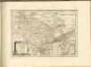
Geographica Provinciarum Sveviae Descriptio =
Mollova mapová sbírka Hurter, Johann Christoph Bodenehr, Gabriel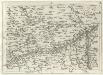
Geographica Provinciarum Sveviae Descriptio =
Mollova mapová sbírka Hurter, Johann Christoph Bodenehr, Johann Georg
Nova et accurata Territorii Vlmensis cum Dominio Wainensi Descriptio
1 : 100000 Mollova mapová sbírka Lauterbach, Johann Christoph Homann, Johann Baptista

Nova et accurata territorii Vlmensis cum dominio Wainensi descriptio
1 : 100000 Bádensko-Württembersko (Německo) Lauterbach, Johann Christoph Homann, Johann Baptist Ioh. Baptista Homann
Nova et accurata territorii Vlmensis cum dominio Wainensi descriptio
1 Karte : Kupferdruck ; 47 x 56 cm Lauterbach; Homann Johann Baptist Homann
Nova et accurata territorii Vlmensis cum dominio Wainensi descriptio
1 Karte : Kupferdruck ; 47 x 56 cm Lauterbach; Homann Johann Baptist Homann
Des Herzogthums Würtemberg ostsüdliche Aemter mit der freyen Reichsstadt Giengen
1 Karte : Kupferdruck ; 23 x 26 cm Reilly F. J. J. von Reilly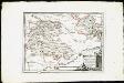
Des Herzogthums Würtemberg ostsüdliche Aemter mit der freyen Reichsstadt Giengen : Nro. 189
Reilly, Franz Johann Joseph von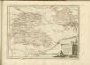

Umgegend von Ulm
1 : 200000 Kartographischen Abtheilung konigl Preuss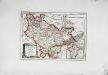
Die freye Reichsstadt Ulm mit ihrem Gebiete
1 Karte : Kupferdruck ; 19 x 27 cm Reilly F. J. J. von Reilly
179. Ulm, uit: Topographische Uebersichtskarte des Deutschen Reiches / herausgegeben v. d. Kartogr. Abt. d. Königl. Preuß. Landesaufnahme
1 : 200000 titelvariant: Topogr. Übersichtskarte des Deutschen Reiches; Annotatie: Titel boven bladen ook: Topogr. Übersichtskarte des Deutschen Reiches; Annotatie geografische gegevens: Op elk blad twee maatstokken: 10 Kilometer = 5,5 cm; 1 geogr. Meile = 3,6 cm; Legenda onder op elk blad Königlich Preußische Landesaufnahme. Kartographische Abtheilung [S.l : Königlich Preußische Landesaufnahme, Kartographische Abtheilung]
Theatrum des Krieges in der Marggrafschaft Burgau
Mollova mapová sbírka Stridbeck, Johann Stridbeck, Johann II
Suevia universa IX. tabulis delineata, 5
1 Blatt : s.n.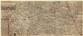
Ilerae Amnis ac Vtrinqve adiacentis Alemanniae Geographica descriptio
1 : 120000 Mollova mapová sbírka Hurter, Johann Christoph Custos, Raphael Hurter, Christoph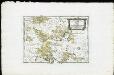
Die Landgrafschaft Nellenburg die Landvogtey Altorf die Grafschaft Hohenberg und die kleinern durch das östreichische Schwaben zerstreuten Besitzungen mit der Stadt Kostanz und den vier Donaustaedten : Nro. 153
Reilly, Franz Johann Joseph von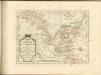
Geographica provinciarum Sueviae descriptio, 4
4 Blätter : Johann Georg Bodenehr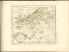
Carte topographique d'Allemagne contenant une partie de Baviere les principautés de Wurtemberg, d'Oettingen
1 Karte : Kupferdruck ; 45 x 63 cm Jaeger se vend chez l'auteur
![Meßtischblatt [7525] : Bermaringen, 1926](https://images-2.georeferencer.com/images/iiif/104048850426/full/,300/0/native.jpg)

