Maps of St. Georges

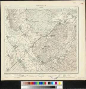
Meßtischblatt 116 : Ehrenstetten, 1930
1 : 250000 Ehrenstetten. - Berichtigt 1893, wichtigere Nachtr. 1930. - 1878 [erschienen ca. 1930].. - 1:25000. - Karlsruhe : Kunstdr. Künstlerbund, 1930. - 1 Kt.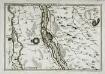
Les environs des deux Brisachs
1 Karte : Kupferdruck ; 23 x 33 cm Fer; Inselin Nicolas de Fer
Nieuwe en naukeurige aftekening van Freiburg met alle zyne sterktens en omleggende landen etc
1 Karte : Kupferdruck ; 43 x 55 cm Ottens; Ottens chez R. et I. Ottens
Le Flambeau de la Guerre Allumee au Rhin
Mollova mapová sbírka Delisle, Guillaume Schenk, Peter II
Geologische Karte der Umgebungen der Bäder Glotterthal und Suggenthal
1 : 50000 Schill, Julius Chr. Fr. Müller'sche Hofbuchhandlung
Friburg, in Brisgouw, aan den Treisamtusschen Brisack en het Swarte Wald
Fribourg (Švýcarsko) Schenk, Pieter P. Schenk
164 Neuf-Brisach.
1 : 86400 Cassini family; Cassini, Cesar-Francois, 1714-1784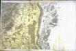
[Neuf-Brisach]
1 Blatt : 61 x 90 cm s.n.
Le cours du Rhin de Bâle à Hert près Philisbourg contenant l'Alsace et partie du Brisgau, 2
1 Blatt : 75 x 52 cm Le Rouge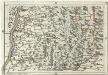
Geographica Provinciarum Sveviae Descriptio =
Mollova mapová sbírka Hurter, Johann Christoph Bodenehr, Gabriel
185. Freiburg i. Brg., uit: Topographische Uebersichtskarte des Deutschen Reiches / herausgegeben v. d. Kartogr. Abt. d. Königl. Preuß. Landesaufnahme
1 : 200000 titelvariant: Topogr. Übersichtskarte des Deutschen Reiches; Annotatie: Titel boven bladen ook: Topogr. Übersichtskarte des Deutschen Reiches; Annotatie geografische gegevens: Op elk blad twee maatstokken: 10 Kilometer = 5,5 cm; 1 geogr. Meile = 3,6 cm; Legenda onder op elk blad Königlich Preußische Landesaufnahme. Kartographische Abtheilung [S.l : Königlich Preußische Landesaufnahme, Kartographische Abtheilung]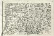
Geographica Provinciarum Sveviae Descriptio =
Mollova mapová sbírka Hurter, Johann Christoph Bodenehr, Johann Georg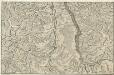
Le Cours du Rhein, depuis Spire jusqu'a Mayence
1 : 180000 Mollova mapová sbírka Fer, Nicolas de Starckman, P. Fer, Nicolas de
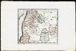
Basiliensis territorii descriptio nova
1 Karte : Kupferdruck ; 31 x 23 cm Münster; Ortelius s.n.
Basiliensis territorii descriptio nova
1 Karte : Kupferdruck ; 31 x 23 cm Münster; Ortelius s.n.
Suevia Universa :
1 : 170000 Mollova mapová sbírka Michal, Jacques de Seutter, Matthäus Seutter, Matthäus
Fernere Erweiterung unserer weiteren Kriegs Progressen von den 11ten Aug: biß 12ten Octob:
Mollova mapová sbírka Lidl, Johann Jakob Lidl, Johann Jacob
Alasatia superior et inferior III. tabulis delineata, 1
1 Blatt : 62 x 62 cm s.n.
Carte du chemin de fer de Strasbourg à Bâle
1 : 80000 Lithographie de Ve Levrault
Freiburg
1 : 200000 Herder, Bartholomew
Carte du chemin de fer de Strasbourg à Bâle
1 : 80000 Lithographie de Ve Levrault
Departement du Haut Rhin
1 Karte : Kupferdruck ; 16 x 14 cm au dépot de l'Atlas national rue de la Monnoye no. 5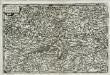
Alsatia svperior
1 Karte : Kupferdruck ; 14 x 22 cm Lambert Andreae
Partie de la Haute Alsace le Suntgaw, et le Brisgaw Partie du Canton de Basle et du Cours du Rhein ou sont les Valles de Brisac Fribourg, Colmars Huningue Befort et Basle
1 : 160000 Mollova mapová sbírka Baillieul, Gaspard Bailleul, Gaspard
Freiburg 141, uit: [W. Liebenow's Special-Karte von Mittel-Europa]
1 : 300000 titelvariant: W. Liebenow's Mittel-Europa; Annotatie: Titel boven de bladen: W. Liebenow's Mittel-Europa Johannes Wilhelm Liebenow 1822-1897 Hannover : Hermann Oppermann
Freiburg 141, uit: Special-Karte von Mittel-Europa / nach amtlichen Quellen bearbeitet von W. Liebenow
1 : 300000 titelvariant: W. Liebenow's Mittel-Europa; Annotatie: Titel boven de bladen: W. Liebenow's Mittel-Europa Johannes Wilhelm Liebenow 1822-1897 Frankfurt a. M. : Ludwig Ravenstein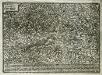
Elsatia svperior
1 Karte : Kupferdruck ; 17 x 27 cm Quad Johannes Bussemacher
Sequani Latobrigi
1 Karte : Kupferdruck ; 40 x 43 cm Sanson; Robert de Vaugondy; Laleman chés le Sr. Robert geog. du roi quai de l'horloge du Palais
Alsatia tem Svperior, quam Inferior una cum Svndgovia
1 : 120000 Mollova mapová sbírka Homann, Johann Baptist Homann, Johann Baptista - dědici