Maps of North Region
(Sheet 3) Mapa Geografico De America Meridional.
1 : 4335200 Ricarte, Hippolytus
Mapa de los ferrocarriles del Peru : de sus principales vias de comunicación terrestres, fluviales y maritimas, y de la futura red ferroviaria según los proyectos formulados con indicación de los vias interfluviales llamadas varaderos
1 : 3000000 Vallejos Z., Camilo Lit. tip. Badiola y Berrio
Karte vom Amazonen Strome
Amazonka-oblast Martius, C. von Schwarzmann, I.
Facsimile: Part of South America by Cruz Cano Y Olmedilla.
Cruz Cano y Olmedilla, Juan de la, d. 1790
Partie, Colombie, Bresil. Amer. Merid. 9.
1 : 1641836 Vandermaelen, Philippe, 1795-1869
Partie du Bresil. Amer. Merid. 10.
1 : 1641836 Vandermaelen, Philippe, 1795-1869
Partie, Perou, Bresil. Amer. Merid. 15.
1 : 1641836 Vandermaelen, Philippe, 1795-1869
Partie du Bresil. Amer. Merid. 16.
1 : 1641836 Vandermaelen, Philippe, 1795-1869
Partie, Colombie. Amer. Merid. 5.
1 : 1641836 Vandermaelen, Philippe, 1795-1869
Partie, Colombie. Amer. Merid. 6.
1 : 1641836 Vandermaelen, Philippe, 1795-1869
(East) Provincia litoral de Loreto.
1 : 1080000 Paz Soldan, Mariano Felipe, 1821-1886
Composite: Provincia litoral de Loreto.
1 : 1080000 Paz Soldan, Mariano Felipe, 1821-1886
(West) Provincia litoral de Loreto.
1 : 1080000 Paz Soldan, Mariano Felipe, 1821-1886
Lago Titicaca : plano formado sobre los trabajos de Pentland, Raimondi, Agassiz, etc. : para la conferencia que en la noche del 21 de Diciembre del ano de 1891, dio en el l'oeal de la Sociedad Geografica, el Dr. Dn. Ignacio La Puenta sobre el estudio monografico del Lago, bajo su aspecto fisico e historico
1 : 500000 Baluarte, Rafael E Sociedad Geografica de Lima
Carta del Canton de Rio Negro, Provincia de Guayana.
1 : 1300000 Codazzi, Agustin, 1793-1859
Asuay.
1 : 2700000 Restrepo, Jose Manuel, 1781-1863
Lecho, Rio Amazonas; Corte vertical, camino de Lima-Cerro de Pasco.
Paz Soldan, Mariano Felipe, 1821-1886
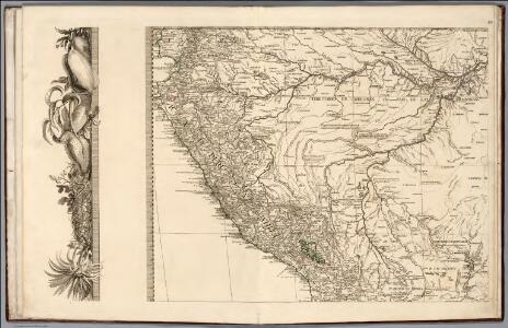
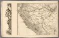
Mapa del Peru
1 : 500000 Raimondi, Antonio 1826-1890 Paris : Erhard Frères
Mapa del Peru
1 : 500000 Raimondi, Antonio 1826-1890 Paris : Erhard Frères
Mapa del Peru
1 : 500000 Raimondi, Antonio 1826-1890 Paris : Erhard Frères
Mapa del Peru
1 : 500000 Raimondi, Antonio 1826-1890 Paris : Erhard Frères
Mapa del Peru
1 : 500000 Raimondi, Antonio 1826-1890 Paris : Erhard Frères
Mapa del Peru
1 : 500000 Raimondi, Antonio 1826-1890 Paris : Erhard Frères
Mapa del Peru
1 : 500000 Raimondi, Antonio 1826-1890 Paris : Erhard Frères
Curacao.
1 : 316800 Lucas, Fielding Jr.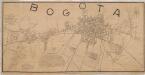
Plano de la ciudad de Bogotá
1 : 10000 Plano de Bogotá, al estilo gráfico “déco” de los años veinte. Muestra una ciudad que se expande al norte (barrios de Chapinero y Sucre), y al sur suroccidente (Luna Park y Ricaurte) rompiendo la traza urbana histórica de la ciudad. En el mapa aparecen también zonas de futura proyección urbana, como los barrios 7 de Agosto, 20 de Julio, entre otros. Además de cementerios, hospitales, tranvías, ferrocarriles, etc., el mapa incluye información de interés para la historia de la ciudad como, por ejemplo, que en ella habitaban 59636 hombres y 84351 mujeres, en 13 barrios, con 608 manzanas edificadas. Rincón O., Manuel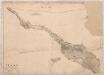
Plano de la parte del camino de occidente entre Tenasuca i la punta de la Mesa. 1850. Por Vicente de la Roche 1850
Plano manuscrito a pluma, que presenta el camino existente, y una propuesta de “trocha nueva”. Roche, Manuel Vicente de la (1823-1897)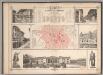
Plano de Bogota
1 : 7700 Paz, Manuel María, 1820-1902
[Land- und Wasserteilung]
Atlas der Hydrographie Berghaus, Hermann Justus Perthes