Maps of gmina Czarnków

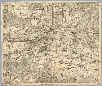
Composite: 250. Czarnikau.
1 : 100000 Reichsamt fur Landesaufnahme
250. Czarnikau.
1 : 100000 Reichsamt fur Landesaufnahme
Meßtischblatt 3165 : Lubasch, 1934
1 : 250000 Lubasch. - Hrsg. 1892, bericht. 1934. - 1:25000. - [Berlin]: Reichsamt für Landesaufnahme, 1934. - 1 Kt.
Meßtischblatt 3164 : Gulcz, 1936
1 : 250000 Gulcz. - Hrsg. 1892, bericht. 1934. - 1:25000. - [Berlin]: Reichsamt für Landesaufnahme, 1936. - 1 Kt.
Meßtischblatt 3166 : Schrotthaus, 1936
1 : 250000 Schrotthaus. - Aufn. 1890, letzte Nachtr. 1934/35. - 1:25000. - [Berlin]: Reichsamt für Landesaufnahme, 1936. - 1 Kt.
Meßtischblatt 1571 : Czarnikau, 1891
1 : 250000 Czarnikau. - Aufn. 1890. - 1:25000. - [Berlin]: Reichsamt für Landesaufnahme, 1891. - 1 Kt.
Meßtischblatt 1570 : Stieglitz, 1892
1 : 250000 Stieglitz. - Aufn. 1890. - 1:25000. - [Berlin]: Reichsamt für Landesaufnahme, 1892. - 1 Kt.
Meßtischblatt 1572 : Gembitz, 1892
1 : 250000 Gembitz. - Aufn. 1890. - 1:25000. - [Berlin]: Reichsamt für Landesaufnahme, 1892. - 1 Kt.
Meßtischblatt 1713 : Polajewo, 1892
1 : 250000 Polajewo. - Aufn. 1890. - 1:25000. - [Berlin]: Reichsamt für Landesaufnahme, 1892. - 1 Kt.
Meßtischblatt 1712 : Obersitzko, 1911
1 : 250000 Obersitzko. - Aufn. 1890, hrsg. 1892, einz. Nachtr. 1911. - 1:25000. - [Berlin]: Reichsamt für Landesaufnahme, 1911. - 1 Kt.
Meßtischblatt 3264 : Wronke, 1940
1 : 250000 Wronke. - Aufn. 1890, hrsg. 1892, letzte Nachtr. 1931, Ausg. 1940. - 1:25000. - [Berlin]: Reichsamt für Landesaufnahme, 1940. - 1 Kt.
80. Czarnikan, uit: Topographische Uebersichtskarte des Deutschen Reiches / herausgegeben v. d. Kartogr. Abt. d. Königl. Preuß. Landesaufnahme
1 : 200000 titelvariant: Topogr. Übersichtskarte des Deutschen Reiches; Annotatie: Titel boven bladen ook: Topogr. Übersichtskarte des Deutschen Reiches; Annotatie geografische gegevens: Op elk blad twee maatstokken: 10 Kilometer = 5,5 cm; 1 geogr. Meile = 3,6 cm; Legenda onder op elk blad Königlich Preußische Landesaufnahme. Kartographische Abtheilung [S.l : Königlich Preußische Landesaufnahme, Kartographische Abtheilung]
Kreuz 49, uit: Special-Karte von Mittel-Europa / nach amtlichen Quellen bearbeitet von W. Liebenow
1 : 300000 titelvariant: W. Liebenow's Mittel-Europa; Annotatie: Titel boven de bladen: W. Liebenow's Mittel-Europa Johannes Wilhelm Liebenow 1822-1897 Frankfurt a. M. : Ludwig Ravenstein
Composite: 249. Filehne.
1 : 100000 Reichsamt fur Landesaufnahme
275. Samter.
1 : 100000 Reichsamt fur Landesaufnahme
Composite: 275. Samter.
1 : 100000 Reichsamt fur Landesaufnahme
251. Wongrowitz.
1 : 100000 Reichsamt fur Landesaufnahme
Composite: 222. Schneidermuhl.
1 : 100000 Reichsamt fur Landesaufnahme
222. Schneidermuhl.
1 : 100000 Reichsamt fur Landesaufnahme
Meßtischblatt 1497 : Schönlanke, 1878
1 : 250000 Schönlanke. - Aufn. 1876. - 1:25000. - [Berlin]: Reichsamt für Landesaufnahme, 1878. - 1 Kt.
Meßtischblatt 2965 : Radolin, 1940
1 : 250000 Radolin. - Aufn. 1935, hrsg. 1938. - 1:25000. - [Berlin]: Reichsamt für Landesaufnahme, 1940. - 1 Kt.
Meßtischblatt Usch
1 : 250000 Usch. - Aufn. 1876/1935, letzte Nachtr. 1935/36. - 1:25000. - [Berlin]: Reichsamt für Landesaufnahme, 1938. - 1 Kt.
Meßtischblatt 3067 : Kolmar in Posen, 1940
1 : 250000 Kolmar in Posen. - Ausg. m. dt. Namen, Ausg. 1940 m. vorläuf. Namen. - 1:25000. - [Berlin]: Reichsamt für Landesaufnahme, 1940. - 1 Kt.
Meßtischblatt 3167 : Budsin, 1936
1 : 250000 Budsin. - Letzte Nachtr. 1934/35. - 1:25000. - [Berlin]: Reichsamt für Landesaufnahme, 1936. - 1 Kt.
Meßtischblatt 3267 : Bülowsthal, 1936
1 : 250000 Bülowsthal. - Aufn. 1888, letzte Nachtr. 1933/35. - 1:25000. - [Berlin]: Reichsamt für Landesaufnahme, 1936. - 1 Kt.

Bromberg
1 : 600000 Opitz, Carl Solbrig

Monumenta Cartographica Bohemiae II.: Müllerova mapa