Maps of gmina Strzelce Krajeńskie

248.1. Friedeberg
1 : 100000 Reichsamt fur Landesaufnahme
248. Friedeberg i. d. Neum.
1 : 100000 Reichsamt fur Landesaufnahme
Composite: 248.1. Friedeberg
1 : 100000 Reichsamt fur Landesaufnahme
Meßtischblatt 3160 : Driesen (West), 1936
1 : 250000 Driesen (West). - Hrsg. 1893, bericht. 1933, einz. Nachtr. 1934. - 1:25000. - [Berlin]: Reichsamt für Landesaufnahme, 1936. - 1 Kt.
Meßtischblatt 3159 : Friedeberg in der Neumark, 1935
1 : 250000 Friedeberg in der Neumark. - Aufgen. 1891, hrsg. 1893, bericht. 1934. - 1:25000. - [Berlin]: Reichsamt für Landesaufnahme, 1935. - 1 Kt.
Meßtischblatt 3059 : Wugarten, 1934
1 : 250000 Wugarten. - Hrsg. 1893, bericht. 1934. - 1:25000. - [Berlin]: Reichsamt für Landesaufnahme, 1934. - 1 Kt.
Meßtischblatt 3060 : Woldenberg, 1934
1 : 250000 Woldenberg. - Hrsg. 1893, bericht. 1934. - 1:25000. - [Berlin]: Reichsamt für Landesaufnahme, 1934. - 1 Kt.
Meßtischblatt 3158 : Altenfließ, 1938
1 : 250000 Altenfließ. - Aufgen. 1891, hrsg. 1893, bericht. 1934, redakt. Änd. [19]38. - 1:25000. - [Berlin]: Reichsamt für Landesaufnahme, 1938. - 1 Kt.
Meßtischblatt 1564 : Büssow, 1893
1 : 250000 Büssow. - Aufn. 1891. - 1:25000. - [Berlin]: Reichsamt für Landesaufnahme, 1893. - 1 Kt.
Meßtischblatt 3260 : Gottschimm, 1938
1 : 250000 Gottschimm. - Hrsg. 1892, bericht. 1934, red. Änd./Namen (Stand vom 1.10.38). - 1:25000. - [Berlin]: Reichsamt für Landesaufnahme, 1938. - 1 Kt.
Meßtischblatt 3259 : Lipke, 1938
1 : 250000 Lipke. - Hrsg. 1893, bericht. 1934, red. Änd. 10.38. - 1:25000. - [Berlin]: Reichsamt für Landesaufnahme, 1938. - 1 Kt.
Meßtischblatt 1705 : Zantoch, 1907
1 : 250000 Zantoch. - Aufn. 1891, hrsg. 1893, einzelne Nachtr. 1907. - 1:25000. - [Berlin]: Reichsamt für Landesaufnahme, 1907. - 1 Kt.
79. Schwerin a.d. Warthe, uit: Topographische Uebersichtskarte des Deutschen Reiches / herausgegeben v. d. Kartogr. Abt. d. Königl. Preuß. Landesaufnahme
1 : 200000 titelvariant: Topogr. Übersichtskarte des Deutschen Reiches; Annotatie: Titel boven bladen ook: Topogr. Übersichtskarte des Deutschen Reiches; Annotatie geografische gegevens: Op elk blad twee maatstokken: 10 Kilometer = 5,5 cm; 1 geogr. Meile = 3,6 cm; Legenda onder op elk blad Königlich Preußische Landesaufnahme. Kartographische Abtheilung [S.l : Königlich Preußische Landesaufnahme, Kartographische Abtheilung]
Kreuz 49, uit: Special-Karte von Mittel-Europa / nach amtlichen Quellen bearbeitet von W. Liebenow
1 : 300000 titelvariant: W. Liebenow's Mittel-Europa; Annotatie: Titel boven de bladen: W. Liebenow's Mittel-Europa Johannes Wilhelm Liebenow 1822-1897 Frankfurt a. M. : Ludwig Ravenstein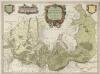
Marchionatus Brandenburgici Partes Duae Nova Marchia et Uckerana
1 : 420000 Mollova mapová sbírka Örnehufvud, Olof Hansson Covens, Johannes I
Composite: 249. Filehne.
1 : 100000 Reichsamt fur Landesaufnahme
Marchia nova Vulgo New Marck in March: Brandenburg
1 : 470000 Mollova mapová sbírka Schenk, Pieter Schenk, Peter I
MARCHIONATUS | BRANDENBURGICI | PARTES DUÆ, | NOVA MARCHIA | et | UCKERANA
Auctore | OLAO JOANNIS GOTHO | Gustaui Magni Cosmographo. [Amsterdam : Joan Blaeu]
Mapa Wojewodztwa Szczecinskiego

Bromberg
1 : 600000 Opitz, Carl Solbrig

Marchia Nova; Vulgò New Marck in March. Brandenburg. [Karte], in: Novus atlas absolutissimus, Bd. 2, S. 63.
1 Karte aus Atlas Janssonius Offizin
Provinz Posen
1 : 1200000 Provinz Posen
Posen.
1 : 810000 Radefeld, Carl Christian Franz, 1788-1874
Palatinatus Posnaniensis. In Majori Polonia Primarii Nova Delinatio [Karte], in: Novus atlas absolutissimus, Bd. 1, S. 96.
1 Karte aus Atlas Janssonius Offizin
Provinz Posen
Grosser Hand-Atlas über alle Theile der Erde in 170 Karten Meyer, J. Verlag des Bibliographischen Instituts
Electoratus sive marchia Brandenburgensis juxta novissimam delineationem in mappa geographica, accurate aeri incisa
1 : 548000 Braniborsko (Německo) Seutter, Matthäus sumptibus Mathaei Seutteri
Electoratus sive marchia Brandenburgensis juxta novissimam delineationem in mappa geographica accurate aeri incisa
1 : 548000 Braniborsko (Německo) Seutter, Matthäus Mathaei Seutteri
Silesia Inferior. [Karte], in: Le théâtre du monde, ou, Nouvel atlas contenant les chartes et descriptions de tous les païs de la terre, Bd. 1, S. 210.
1 Karte aus Atlas Blaeu, Willem Janszoon und Blaeu, Joan Blaeu, Willem Janszoon


