Maps of gmina Szamocin

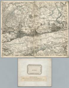
223. Wirsitz.
1 : 100000 Reichsamt fur Landesaufnahme
Meßtischblatt 2968 : Samotschin, 1940
1 : 250000 Samotschin. - Aufn. 1876, hrsg. 1878, letzte Nachtr. 1936. - 1:25000. - [Berlin]: Reichsamt für Landesaufnahme, 1940. - 1 Kt.
Meßtischblatt 1502 : Jaktorowo, 1913
1 : 250000 Jaktorowo. - Aufn. 1876, hrsg. 1878, Auflagedr. 1913. - 1:25000. - [Berlin]: Reichsamt für Landesaufnahme, 1913. - 1 Kt.
Meßtischblatt 2868 : Wissek, 1936
1 : 250000 Wissek. - Aufn. 1876, hrsg. 1878, letzte Nachtr. 1936. - 1:25000. - [Berlin]: Reichsamt für Landesaufnahme, 1936. - 1 Kt.
Meßtischblatt 2869 : Wirsitz, 1936
1 : 250000 Wirsitz. - Aufn. 1876, hrsg. 1878, letzte Nachtr. 1936. - 1:25000. - [Berlin]: Reichsamt für Landesaufnahme, 1936. - 1 Kt.
Meßtischblatt 2967 : Morzewo, 1940
1 : 250000 Morzewo. - Aufn. 1876, hrsg. 1878. - 1:25000. - [Berlin]: Reichsamt für Landesaufnahme, 1940. - 1 Kt.
Meßtischblatt 2867 : Schmilau, 1936
1 : 250000 Schmilau. - Aufn. 1935, letzte Nachtr. 1936. - 1:25000. - [Berlin]: Reichsamt für Landesaufnahme, 1936. - 1 Kt.
Composite: 223. Wirsitz.
1 : 100000 Reichsamt fur Landesaufnahme
Meßtischblatt 2768 : Preußenfeld, 1937
1 : 250000 Preußenfeld. - Hrsg. 1925, einz. Nachtr. 1934, mehrfarb. Ausg. - 1:25000. - [Berlin]: Reichsamt für Landesaufnahme, 1937. - 1 Kt.
Meßtischblatt 2769 : Wilhelmshof, 1933
1 : 250000 Wilhelmshof. - Hrsg. 1923. - 1:25000. - [Berlin]: Reichsamt für Landesaufnahme, 1933. - 1 Kt.
Meßtischblatt 2767 : Krojanke, 1938
1 : 250000 Krojanke. - Aufn. 1928, letzte Nachtr. 1934, redakt. Änd. 1938. - 1:25000. - [Berlin]: Reichsamt für Landesaufnahme, 1938. - 1 Kt.
Meßtischblatt 2870 : Sadke, 1937
1 : 250000 Sadke. - Aufn. 1876, letzte Nachtr. 1936/37. - 1:25000. - [Berlin]: Reichsamt für Landesaufnahme, 1937. - 1 Kt.
Meßtischblatt 2970 : Gromaden, 1940
1 : 250000 Gromaden. - Aufn. 1876, hrsg. 1878, letzte Nachtr. 1935. - 1:25000. - [Berlin]: Reichsamt für Landesaufnahme, 1940. - 1 Kt.
272. Landsberg a. d. Warthe.
1 : 100000 Reichsamt fur Landesaufnahme
251. Wongrowitz.
1 : 100000 Reichsamt fur Landesaufnahme
222. Schneidermuhl.
1 : 100000 Reichsamt fur Landesaufnahme
Meßtischblatt 2770 : Dembno, 1938 ?
1 : 250000 Dembno. - Aufn. 1909 ?. - 1:25000. - [Berlin]: Reichsamt für Landesaufnahme, 1938 ?. - 1 Kt.
Meßtischblatt 3069 : Gollantsch, 1940
1 : 250000 Gollantsch. - Ausg. m. dt. Namen, Ausg. 1940 m. vorläuf. Namen. - 1:25000. - [Berlin]: Reichsamt für Landesaufnahme, 1940. - 1 Kt.
Meßtischblatt 3068 : Margonin, 1940
1 : 250000 Margonin. - Ausg. m. dt. Namen, Ausg. 1940 m. vorläuf. Namen. - 1:25000. - [Berlin]: Reichsamt für Landesaufnahme, 1940. - 1 Kt.
Meßtischblatt 1574 : Margonin, 1889
1 : 250000 Margonin. - Aufn. 1888. - 1:25000. - [Berlin]: Reichsamt für Landesaufnahme, 1889. - 1 Kt.
Meßtischblatt 3067 : Kolmar in Posen, 1940
1 : 250000 Kolmar in Posen. - Ausg. m. dt. Namen, Ausg. 1940 m. vorläuf. Namen. - 1:25000. - [Berlin]: Reichsamt für Landesaufnahme, 1940. - 1 Kt.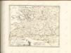

Sect. 10: Bromberg, uit: Geologische Karte des Deutschen Reichs in 27 Blaettern / [von] Richard Lepsius ; Red. von C. Vogel
1 : 500000 Annotatie: Blad 18 ontbreekt; Een aantal bladen op linnen; Een aantal bladen gereviseerd 1913-1914; Annotatie geografische gegevens: Met schaalstokken o.a. in kilometers; Legenda Carl Vogel 1828-1897 Gotha : Justus Perthes
Bromberg
1 : 600000 Opitz, Carl Solbrig
Monumenta Cartographica Bohemiae II.: Müllerova mapa

Provinz Posen
1 : 1200000 Provinz Posen
Posen.
1 : 810000 Radefeld, Carl Christian Franz, 1788-1874
Palatinatus Posnaniensis. In Majori Polonia Primarii Nova Delinatio [Karte], in: Novus atlas absolutissimus, Bd. 1, S. 96.
1 Karte aus Atlas Janssonius Offizin
Languages in Prussian Poland
1 : 600000 First World War map of Languages in Prussian Poland. War Office