Maps of gmina Widuchowa

218. Gartz a. d. O. (Germany)
1 : 100000 Reichsamt fur Landesaufnahme
Composite: 218. Gartz a. d. O. (Germany)
1 : 100000 Reichsamt fur Landesaufnahme
Meßtischblatt 1487 : Beyersdorf, 1927
1 : 250000 Beyersdorf. - Aufn. 1888, einz. Nachtr. 1927. - 1:25000. - [Berlin]: Reichsamt für Landesaufnahme, 1927. - 1 Kt.
Meßtischblatt 1486, neue Nr. 2953 : Wildenbruch in Pommern, 1937
1 : 250000 Wildenbruch in Pommern. - Hrsg. 1889, kl. Nachtr. 1924. - 1:25000. - [Berlin]: Reichsamt für Landesaufnahme, 1937. - 1 Kt.
Meßtischblatt 1485, neue Nr. 2952 : Uchtdorf, 1938
1 : 250000 Uchtdorf. - Hrsg. 1890, bericht. 1933, redakt. Änd. [19]38. - 1:25000. - [Berlin]: Reichsamt für Landesaufnahme, 1938. - 1 Kt.
Meßtischblatt 1485 : Uchtdorf, 1913
1 : 250000 Uchtdorf. - Aufn. 1888, hrsg. 1890, Auflagedr. 1913. - 1:25000. - [Berlin]: Reichsamt für Landesaufnahme, 1913. - 1 Kt.
Meßtischblatt 1407 : Schwochow, 1925
1 : 250000 Schwochow. - Hrsg. 1889, einz. Nachtr. 1925. - 1:25000. - [Berlin]: Reichsamt für Landesaufnahme, 1925. - 1 Kt.
Meßtischblatt 2853 : Bahn, 1924
1 : 250000 Bahn. - Aufn. 1888, kl. Nachtr. 1924. - 1:25000. - [Berlin]: Reichsamt für Landesaufnahme, 1924. - 1 Kt.
Meßtischblatt 1405 : Fiddichow, 1890
1 : 250000 Fiddichow. - Aufn. 1881. - 1:25000. - [Berlin]: Reichsamt für Landesaufnahme, 1890. - 1 Kt.
Meßtischblatt 1324 : Greifenhagen, 1933
1 : 250000 Greifenhagen. - Hrsg. 1888, bericht. 1933. - 1:25000. - [Berlin]: Reichsamt für Landesaufnahme, 1933. - 1 Kt.
Meßtischblatt 1325 : Woltin, 1933
1 : 250000 Woltin. - Hrsg. 1888, kl. Nachtr. 1921, Neuaufn. d. Oder 1929, gedr. [19]33. - 1:25000. - [Berlin]: Reichsamt für Landesaufnahme, 1933. - 1 Kt.
Meßtischblatt 1326 : Neumark in Pommern, 1919
1 : 250000 Neumark in Pommern. - Aufn. 1886, kl. Nachtr. 1919. - 1:25000. - [Berlin]: Reichsamt für Landesaufnahme, 1919. - 1 Kt.
62. Stettin, uit: Topographische Uebersichtskarte des Deutschen Reiches / herausgegeben v. d. Kartogr. Abt. d. Königl. Preuß. Landesaufnahme
1 : 200000 titelvariant: Topogr. Übersichtskarte des Deutschen Reiches; Annotatie: Titel boven bladen ook: Topogr. Übersichtskarte des Deutschen Reiches; Annotatie geografische gegevens: Op elk blad twee maatstokken: 10 Kilometer = 5,5 cm; 1 geogr. Meile = 3,6 cm; Legenda onder op elk blad Königlich Preußische Landesaufnahme. Kartographische Abtheilung [S.l : Königlich Preußische Landesaufnahme, Kartographische Abtheilung]
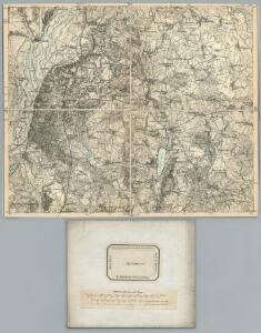
Composite: 217. Schwedt. (Germany)
1 : 100000 Reichsamt fur Landesaufnahme
Meßtischblatt 1484 : Schwedt, 1933
1 : 250000 Schwedt. - Hrsg. 1889, bericht. 1933. - 1:25000. - [Berlin]: Reichsamt für Landesaufnahme, 1933. - 1 Kt.
Meßtischblatt 1484 : Schwedt, 1921
1 : 250000 Schwedt. - Aufn. 1888, Nachtr. 1921. - 1:25000. - [Berlin]: Reichsamt für Landesaufnahme, 1921. - 1 Kt.
Meßtischblatt 2851 : Kunow, 1953
1 : 250000 Kunow. - Hrsg. 1890, letzte Nachtr. 1932, Ausgabe 1937. - 1:25000. - [S.l.]: VDB, 1953. - 1 Kt.
Meßtischblatt 2751 : Penkun, 1932
1 : 250000 Penkun. - Hrsg. 1888, bericht. 1911, letzte Nachtr. 1932. - 1:25000. - [Berlin]: Reichsamt für Landesaufnahme, 1932. - 1 Kt.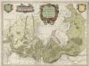
Marchionatus Brandenburgici Partes Duae Nova Marchia et Uckerana
1 : 420000 Mollova mapová sbírka Örnehufvud, Olof Hansson Covens, Johannes I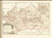

Küstrin 48, uit: Special-Karte von Mittel-Europa / nach amtlichen Quellen bearbeitet von W. Liebenow
1 : 300000 titelvariant: W. Liebenow's Mittel-Europa; Annotatie: Titel boven de bladen: W. Liebenow's Mittel-Europa Johannes Wilhelm Liebenow 1822-1897 Frankfurt a. M. : Ludwig Ravenstein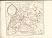

Theatrum belli in Pomerania Citeriori
1 : 140000 Mollova mapová sbírka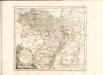

Der Soldinsche Creis
1 : 296000 Myślibórz (Polsko) Sotzmann, Daniel Friedrich Glassbach, Carl Christian
Abbildung der sehr grossen und blutigen Feldschlacht, welche am 25. August 1758 bei Zorndorf, ohnweit Cüstrin, zwischen der König. Preussischen Armée, unter Se. Königl. Maj. Höchsteigener Anführung, und der Russischen, unter Commando des Generals von Fermor, vorgefallen. bei welcher Se. König. Maj. abermal einen vollkommenen Sieg erfochten, ohnerachtet der grossen Überlegenheit der Feinde, sowol an Mannschaft als Geschütze, und der vorteilhaften Stellung, welche sie zwischen Wäldern und Morästen genommen

217. Schwedt. (Germany)
1 : 100000 Reichsamt fur Landesaufnahme
Composite: 187. Stettin. (Germany)
1 : 100000 Reichsamt fur Landesaufnahme
246. Konigsberg i.d. Neumark.
1 : 100000 Reichsamt fur Landesaufnahme