Maps of Oldenburg

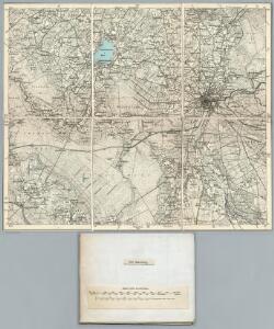
205. Oldenburg. (Germany)
1 : 100000 Reichsamt fur Landesaufnahme
Composite: 205. Oldenburg. (Germany)
1 : 100000 Reichsamt fur Landesaufnahme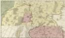
Comitatus Oldenburgensis]
Mollova mapová sbírka Loon, Jan van Schenk, Peter I
Meßtischblatt 1522 : Dötlingen, 1935
1 : 250000 Dötlingen. - Hrsg. 1900, einz. Nachtr. 1925, [gedr.] [19]35. - 1:25000. - [Berlin]: Reichsamt für Landesaufnahme, 1935. - 1 Kt.
Meßtischblatt 1522 : Dötlingen, 1900
1 : 250000 Dötlingen. - Aufn. 1898. - 1:25000. - [Berlin]: Reichsamt für Landesaufnahme, 1900. - 1 Kt.
Meßtischblatt 1521 : Grossenkneten, 1925
1 : 250000 Grossenkneten. - Aufn. 1898, einz. Nachtr. 1925. - 1:25000. - [Berlin]: Reichsamt für Landesaufnahme, 1925. - 1 Kt.
Meßtischblatt 1519 : Markhausen, 1900
1 : 250000 Markhausen. - Aufn. 1898. - 1:25000. - [Berlin]: Reichsamt für Landesaufnahme, 1900. - 1 Kt.
Meßtischblatt 1520 : Garrel, 1900
1 : 250000 Garrel. - Aufn. 1898. - 1:25000. - [Berlin]: Reichsamt für Landesaufnahme, 1900. - 1 Kt.
Messtischblatt 1449 : Kirchhatten, 1900 Kirchhatten
1 : 250000 Kirchhatten. - Aufn. 1898. - 1:25000. - [Berlin]: Reichsamt für Landesaufnahme, 1900. - 1 Kt.
Messtischblatt 1448 : Wardenburg, 1925 Wardenburg
1 : 250000 Wardenburg. - Aufn. 1898, Nachtr. 1925. - 1:25000. - [Berlin]: Reichsamt für Landesaufnahme, 1925. - 1 Kt.
Messtischblatt 1446 : Friesoythe, 1925 Friesoythe
1 : 250000 Friesoythe. - Aufn. 1898, einz. Nachtr. 1925. - 1:25000. - [Berlin]: Reichsamt für Landesaufnahme, 1925. - 1 Kt.
Messtischblatt 1446 : Friesoythe, 1900 Friesoythe
1 : 250000 Friesoythe. - Aufn. 1898. - 1:25000. - [Berlin]: Reichsamt für Landesaufnahme, 1900. - 1 Kt.
Messtischblatt 1447 : Littel, 1925 Littel
1 : 250000 Littel. - Aufn. 1898, einz. Nachtr. 1925. - 1:25000. - [Berlin]: Reichsamt für Landesaufnahme, 1925. - 1 Kt.
Meßtischblatt 1369 : Berne, 1934
1 : 250000 Berne. - Hrsg. 1900, bericht. 1913, einz. Nachtr. 1925. - 1:25000. - [Berlin]: Reichsamt für Landesaufnahme, 1934. - 1 Kt.
Meßtischblatt 1368 : Oldenburg, 1934
1 : 250000 Oldenburg. - Hrsg. 1899, einz. Nachtr. 1934. - 1:25000. - [Berlin]: Reichsamt für Landesaufnahme, 1934. - 1 Kt.
Meßtischblatt 1368 : Oldenburg, 1899
1 : 250000 Oldenburg. - Aufn. 1898. - 1:25000. - [Berlin]: Reichsamt für Landesaufnahme, 1899. - 1 Kt.
Meßtischblatt 1366 : Edewecht, 1900
1 : 250000 Edewecht. - Aufn. 1898, hrsg. 1900. - 1:25000. - [Berlin]: Reichsamt für Landesaufnahme, 1900. - 1 Kt.
Meßtischblatt 1367 : Bad Zwischenahn, 1934
1 : 250000 Bad Zwischenahn. - Hrsg. 1900, einz. Nachtr. 1925. - 1:25000. - [Berlin]: Reichsamt für Landesaufnahme, 1934. - 1 Kt.
Meßtischblatt 1285 : Westerstede, 1900
1 : 250000 Westerstede. - Aufn. 1898. - 1:25000. - [Berlin]: Reichsamt für Landesaufnahme, 1900. - 1 Kt.
Meßtischblatt 1286 : Wiefelstede, 1900
1 : 250000 Wiefelstede. - Aufn. 1898. - 1:25000. - [Berlin]: Reichsamt für Landesaufnahme, 1900. - 1 Kt.
Meßtischblatt 1287 : Rastede, 1899
1 : 250000 Rastede. - Aufn. 1898. - 1:25000. - [Berlin]: Reichsamt für Landesaufnahme, 1899. - 1 Kt.
Meßtischblatt 1288 : Elsfleth, 1917
1 : 250000 Elsfleth. - Aufn. 1898, hrsg. 1900, Auflagedr. 1917. - 1:25000. - [Berlin]: Reichsamt für Landesaufnahme, 1917. - 1 Kt.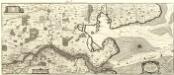
Nobilis Saxoniae Fl. Visvrgis cum Terris adjacentib. Ab Inclyta Brema ad Ostium Maris
1 : 130000 Mollova mapová sbírka Merian, Matthaeus Merian, Matthäus - dědici
Comitatvvm Oldenbvrg et Delmenhorst
1 : 166000 Oldenburg (Německo) Hunrichs, Johann Wilhelm Anton Münnich, Anton Günther von Homannianorum heredum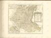

Comitatvvm Oldenbvrg et Delmenhorst
1 : 170000 Mollova mapová sbírka Hunrichs, Johann Wilhelm Anton Homann, Johann Baptista - dědici
Bremen 44, uit: Special-Karte von Mittel-Europa / nach amtlichen Quellen bearbeitet von W. Liebenow
1 : 300000 titelvariant: W. Liebenow's Mittel-Europa; Annotatie: Titel boven de bladen: W. Liebenow's Mittel-Europa Johannes Wilhelm Liebenow 1822-1897 Frankfurt a. M. : Ludwig Ravenstein
55. Oldenburg, uit: Topographische Uebersichtskarte des Deutschen Reiches / herausgegeben v. d. Kartogr. Abt. d. Königl. Preuß. Landesaufnahme
1 : 200000 titelvariant: Topogr. Übersichtskarte des Deutschen Reiches; Annotatie: Titel boven bladen ook: Topogr. Übersichtskarte des Deutschen Reiches; Annotatie geografische gegevens: Op elk blad twee maatstokken: 10 Kilometer = 5,5 cm; 1 geogr. Meile = 3,6 cm; Legenda onder op elk blad Königlich Preußische Landesaufnahme. Kartographische Abtheilung [S.l : Königlich Preußische Landesaufnahme, Kartographische Abtheilung]
206. Bremen. (Germany)
1 : 100000 Reichsamt fur Landesaufnahme