Maps of gmina Biała Piska

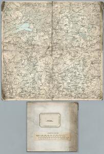
202. (170. Bialla). Gehsen. (Germany)
1 : 100000 Reichsamt fur Landesaufnahme
170. Bialla (202. Gehsen). (Germany)
1 : 100000 Reichsamt fur Landesaufnahme
Composite: 202.1. (170. Bialla). Gehsen. (Germany)
1 : 100000 Reichsamt fur Landesaufnahme
Meßtischblatt 2498/2598 : Kölmerfelde, 1927
1 : 250000 Kölmerfelde. - Hrsg. 1912, bericht. 1927. - 1:25000. - [Berlin]: Reichsamt für Landesaufnahme, 1927. - 1 Kt.
Meßtischblatt 2398 : Gehlenburg, 1938
1 : 250000 Gehlenburg. - Aufn. 1912, bericht. 1927, redakt. Änd. 1938. - 1:25000. - [Berlin]: Reichsamt für Landesaufnahme, 1938. - 1 Kt.
Meßtischblatt 2497 : Morgen, 1938
1 : 250000 Morgen. - Hrsg. 1912, bericht. 1927, redakt. Änd. 1938. - 1:25000. - [Berlin]: Reichsamt für Landesaufnahme, 1938. - 1 Kt.
Meßtischblatt 2397 : Gr. Kessel, 1938
1 : 250000 Gr. Kessel. - Aufn. 1912, bericht. 1927, einz. Nachtr. 1938. - 1:25000. - [Berlin]: Reichsamt für Landesaufnahme, 1938. - 1 Kt.
Meßtischblatt 2499 : Schwiddern, 1938
1 : 250000 Schwiddern. - Hrsg. 1910, redakt. Änd. 1938. - 1:25000. - [Berlin]: Reichsamt für Landesaufnahme, 1938. - 1 Kt.
Meßtischblatt 2399 : Großrosen, 1938
1 : 250000 Großrosen. - Aufn. 1912, bericht. 1927, redakt. Änd. 1938. - 1:25000. - [Berlin]: Reichsamt für Landesaufnahme, 1938. - 1 Kt.
Composite: 170.1. Bialla (202. Gehsen) (Germany)
1 : 100000 Reichsamt fur Landesaufnahme
202.1. (170. Bialla). Gehsen. (Germany)
1 : 100000 Reichsamt fur Landesaufnahme
170.1. Bialla (202. Gehsen). (Germany)
1 : 100000 Reichsamt fur Landesaufnahme
Meßtischblatt 2298 : Seebrücken, 1938
1 : 250000 Seebrücken. - Hrsg. 1912, bericht. 1921, einz. Nachtr. 1938. - 1:25000. - [Berlin]: Reichsamt für Landesaufnahme, 1938. - 1 Kt.
Meßtischblatt 2297 : Stollendorf, 1938
1 : 250000 Stollendorf. - Hrsg. 1912, bericht. 1921, einz. Nachtr. 1938. - 1:25000. - [Berlin]: Reichsamt für Landesaufnahme, 1938. - 1 Kt.
Germany 1:100,000 , Series GSGS 2739, (Sheet 17E)
This map series of which this is part - Germany 1:100,000 , Series GSGS 2739 - are reproductions of German mapping with English marginalia. Great Britain. General Staff. Geographical Section. [London] : [GSGS, War Office]
Regni Borussiae Episcopatus Warmiensis Palatinatus Mariaeburgensis et Culmensis cum Territorio Dantiscano et Ichnographia Urbis Regiomontis].
Mollova mapová sbírka
Meßtischblatt 2299 : Monethen, 1934
1 : 250000 Monethen. - Hrsg. 1912, bericht. 1927, einz. Nachtr. 1932. - 1:25000. - [Berlin]: Reichsamt für Landesaufnahme, 1934. - 1 Kt.
Meßtischblatt 2597 : Gehsen, 1938
1 : 250000 Gehsen. - Hrsg. 1910 ?. - 1:25000. - [Berlin]: Reichsamt für Landesaufnahme, 1938. - 1 Kt.

Obwod Białostocki
Białystok-oblast (Polsko)
Winterschlacht in Masuren
1 : 2000000 Masuren Schlacht, Weltkrieg <1914-1918>
Sect. 11: Allenstein, uit: Geologische Karte des Deutschen Reichs in 27 Blaettern / [von] Richard Lepsius ; Red. von C. Vogel
1 : 500000 Annotatie: Blad 18 ontbreekt; Een aantal bladen op linnen; Een aantal bladen gereviseerd 1913-1914; Annotatie geografische gegevens: Met schaalstokken o.a. in kilometers; Legenda Carl Vogel 1828-1897 Gotha : Justus Perthes
Nr. 21a. Weitere Ergebnisse der Winterschlacht in Masuren
Masuren Weltkrieg <1914-1918>, Ostfront
Provinz Ostpreussen
1 : 1250000 Ostpreußen
Litauisch und Masurisch
Ostpreußen Litauisch, Masurisch
Königsberg, Guttstadt, Biełostok, Suwałki
1 : 750000 Białystok (Polsko : oblast) Konrad, Adalbert K. u. k. Militärgeographisches Institut
Königsberg, Guttstadt, Bielostok, Suwalki
1 : 750000 Białystok (Polsko : oblast) K. k. militär-geographisches Institut
Ost-Preussen.
1 : 935000 Flemming, Carl