Maps of gmina Pruszcz

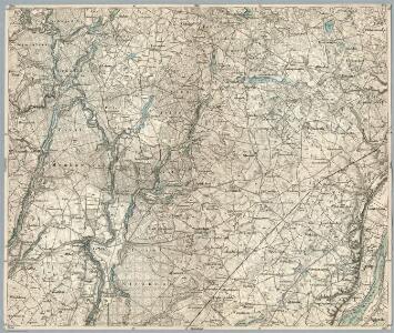
Composite: 194. Crone a. d. Brahe. (Germany)
1 : 100000 Reichsamt fur Landesaufnahme
Meßtischblatt 2674 : Schirotzken, 1936
1 : 250000 Schirotzken. - Aufn. 1911, letzte Nachtr. 1934. - 1:25000. - [Berlin]: Reichsamt für Landesaufnahme, 1936. - 1 Kt.
Meßtischblatt 2673 : Crone a.d.Brahe, 1913
1 : 250000 Crone a.d.Brahe. - Aufn. 1911. - 1:25000. - [Berlin]: Reichsamt für Landesaufnahme, 1913. - 1 Kt.
Meßtischblatt 2675 : Grutschno, 1936
1 : 250000 Grutschno. - Aufn. 1911, letzte Nachtr. 1934. - 1:25000. - [Berlin]: Reichsamt für Landesaufnahme, 1936. - 1 Kt.
Meßtischblatt 2573 : Klonowo, 1934
1 : 250000 Klonowo. - Aufn. 1911, letzte Nachtr. 1934. - 1:25000. - [Berlin]: Reichsamt für Landesaufnahme, 1934. - 1 Kt.
Meßtischblatt 2574 : Lubiewo, 1934
1 : 250000 Lubiewo. - Aufn. 1911, letzte Nachtr. 1934. - 1:25000. - [Berlin]: Reichsamt für Landesaufnahme, 1934. - 1 Kt.
Meßtischblatt 2575 : Heinrichsdorf, 1934
1 : 250000 Heinrichsdorf. - Aufn. 1911, letzte Nachtr. 1934. - 1:25000. - [Berlin]: Reichsamt für Landesaufnahme, 1934. - 1 Kt.
193. Zempelburg. (Germany)
1 : 100000 Reichsamt fur Landesaufnahme
Meßtischblatt 2775 : Rasmushausen, 1940
1 : 250000 Rasmushausen. - Aufn. 1904, letzte Nachtr. 1934/35. - 1:25000. - [Berlin]: Reichsamt für Landesaufnahme, 1940. - 1 Kt.
Meßtischblatt 2774 : Zolondowo, 1940
1 : 250000 Zolondowo. - Aufn. 1909/11, letzte Nachtr. 1932. - 1:25000. - [Berlin]: Reichsamt für Landesaufnahme, 1940. - 1 Kt.
Meßtischblatt 2773 : Wtelno, 1938
1 : 250000 Wtelno. - Aufn. 1910/11, hrsg. 1913, letzte Nachtr. 1932. - 1:25000. - [Berlin]: Reichsamt für Landesaufnahme, 1938. - 1 Kt.
Bromberg 38, uit: Special-Karte von Mittel-Europa / nach amtlichen Quellen bearbeitet von W. Liebenow
1 : 300000 titelvariant: W. Liebenow's Mittel-Europa; Annotatie: Titel boven de bladen: W. Liebenow's Mittel-Europa Johannes Wilhelm Liebenow 1822-1897 Frankfurt a. M. : Ludwig Ravenstein
Composite: 225. Bromberg.
1 : 100000 Reichsamt fur Landesaufnahme
Composite: 195. Kulm. (Germany)
1 : 100000 Reichsamt fur Landesaufnahme
Meßtischblatt 2676 : Kulm, 1940
1 : 250000 Kulm. - Aufn. 1904, hrsg. 1906, letzte Nachtr. 1929. - 1:25000. - [Berlin]: Reichsamt für Landesaufnahme, 1940. - 1 Kt.
Meßtischblatt 2576 : Schwetz, 1933
1 : 250000 Schwetz. - Aufn. 1904, hrsg. 1905, letzte Nachtr. 1933. - 1:25000. - [Berlin]: Reichsamt für Landesaufnahme, 1933. - 1 Kt.
Meßtischblatt 2776 : Unislaw, 1940
1 : 250000 Unislaw. - Aufn. 1904, hrsg. 1906. - 1:25000. - [Berlin]: Reichsamt für Landesaufnahme, 1940. - 1 Kt.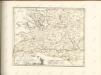

Sect. 10: Bromberg, uit: Geologische Karte des Deutschen Reichs in 27 Blaettern / [von] Richard Lepsius ; Red. von C. Vogel
1 : 500000 Annotatie: Blad 18 ontbreekt; Een aantal bladen op linnen; Een aantal bladen gereviseerd 1913-1914; Annotatie geografische gegevens: Met schaalstokken o.a. in kilometers; Legenda Carl Vogel 1828-1897 Gotha : Justus Perthes
Bromberg
1 : 600000 Opitz, Carl Solbrig
Provinz Posen
1 : 1200000 Provinz Posen
Posen.
1 : 810000 Radefeld, Carl Christian Franz, 1788-1874
Palatinatus Posnaniensis. In Majori Polonia Primarii Nova Delinatio [Karte], in: Novus atlas absolutissimus, Bd. 1, S. 96.
1 Karte aus Atlas Janssonius Offizin
Languages in Prussian Poland
1 : 600000 First World War map of Languages in Prussian Poland. War Office
Die polnische Curve in Westpreußen
Polen Westpreußen Polen Bevölkerung
Provinz Westpreussen
1 : 1250000 Westpreußen
Kreise der Provinz Posen 1864
Preußen, Provinz Posen, Verwaltungsgliederung Kunz, Andreas ; Moeschl, Joachim Robert
Provinz Westpreussen
1 : 472000 Gdaňsk (Polsko) Handtke, Friedrich Carl Flemming
Danzig, Colberg, Thorn
1 : 750000 Gdaňsk (Polsko : oblast) Konrad, A. K. u. k. Militärgeographisches Institut