Maps of gmina Grajewo

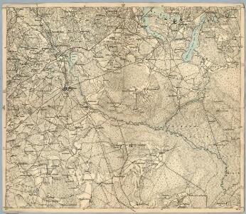
Composite: 171. Ostrokollen. (Germany)
1 : 100000 Reichsamt fur Landesaufnahme
171. Ostrokollen. (Germany)
1 : 100000 Reichsamt fur Landesaufnahme
Meßtischblatt 23100 : Prostken, 1938
1 : 250000 Prostken. - Aufn. 1911, bericht. 1925, redakt. Änd. 1938. - 1:25000. - [Berlin]: Reichsamt für Landesaufnahme, 1938. - 1 Kt.
Meßtischblatt 22101/23101 : Kölmersdorf, 1938
1 : 250000 Kölmersdorf. - Hrsg. 1912, bericht. 1925, redakt. Änd. 1938. - 1:25000. - [Berlin]: Reichsamt für Landesaufnahme, 1938. - 1 Kt.
Meßtischblatt 22102 : Lyssewen, 1925
1 : 250000 Lyssewen. - Aufn. 1910, bericht. 1925. - 1:25000. - [Berlin]: Reichsamt für Landesaufnahme, 1925. - 1 Kt.
Meßtischblatt 22100 : Scharfenrade, 1938
1 : 250000 Scharfenrade. - Hrsg. 1912, redakt. Änd. 1938. - 1:25000. - [Berlin]: Reichsamt für Landesaufnahme, 1938. - 1 Kt.
Germany 1:100,000 , Series GSGS 2739, (Sheet 17E)
This map series of which this is part - Germany 1:100,000 , Series GSGS 2739 - are reproductions of German mapping with English marginalia. Great Britain. General Staff. Geographical Section. [London] : [GSGS, War Office]
170.1. Bialla (202. Gehsen). (Germany)
1 : 100000 Reichsamt fur Landesaufnahme

29 Augustowo, uit: Special-Karte von Mittel-Europa / nach amtlichen Quellen bearbeitet von W. Liebenow
1 : 300000 titelvariant: W. Liebenow's Mittel-Europa; Annotatie: Titel boven de bladen: W. Liebenow's Mittel-Europa Johannes Wilhelm Liebenow 1822-1897 Frankfurt a. M. : Ludwig Ravenstein

Obwod Białostocki
Białystok-oblast (Polsko)
Winterschlacht in Masuren
1 : 2000000 Masuren Schlacht, Weltkrieg <1914-1918>
Nr. 21a. Weitere Ergebnisse der Winterschlacht in Masuren
Masuren Weltkrieg <1914-1918>, Ostfront
Provinz Ostpreussen
1 : 1250000 Ostpreußen
Litauisch und Masurisch
Ostpreußen Litauisch, Masurisch
Königsberg, Guttstadt, Biełostok, Suwałki
1 : 750000 Białystok (Polsko : oblast) Konrad, Adalbert K. u. k. Militärgeographisches Institut
Königsberg, Guttstadt, Bielostok, Suwalki
1 : 750000 Białystok (Polsko : oblast) K. k. militär-geographisches Institut
Ost-Preussen.
1 : 935000 Flemming, Carl
Übersichtskarte von Mittel - Europa

Übersichtskarte von Mittel - Europa

Plan einer trigonometrischen Ausmessung welche in den Jahren 1796 und 1797 in Ostpreussen und Lithauen ausgeführt worden
1 : 800000 Landes-Industrie-Comptoir
[Recto], uit: Archangel Port : revised plan of saw mills and loading places
1 : 90000 Annotatie geografische gegevens: Met legenda, 1-45 Archangel : A.J. Anderson & Son

Provinz Ost - Preussen

Tabula PRUSSIAE EXIMIA CURA CONSCRIPTA
1 : 710000 Kaliningrad (Rusko) Hennenberger, Kaspar Goos, Abraham per Nicolaum Iohannidem Piscatorem
Carte des Königreichs Preussen
Suchodoletz, Johann Vladislaus von
Magnae Prussiae ducatus tabula
1 : 711000 Prusko Visscher, Nicolaus per Nicolaum Visscher
PRVSSIA
ACCVRATE DESCRIPTA | a Gasparo Henneberg | Erlichensi. Excud. Guiljelmus Janß. Cæsius.