Maps of gmina Stepnica

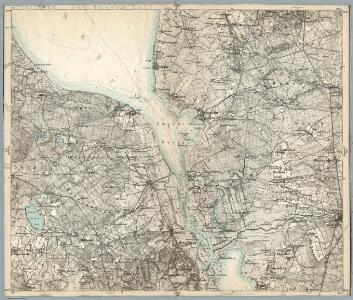
Composite: 155. Politz. (Germany)
1 : 100000 Reichsamt fur Landesaufnahme
Ostsee
1 : 25000 Odra (řeka : oblast) Reichs-Marine-Amt
Meßtischblatt 2454 : Gollnow, 1910
1 : 250000 Gollnow. - Aufn. 1886, hrsg. 1888, einz. Nachtr. 1898, gedr. [19]10. - 1:25000. - [Berlin]: Reichsamt für Landesaufnahme, 1910. - 1 Kt.
Meßtischblatt 2453 : Pölitz, 1938
1 : 250000 Pölitz. - Hrsg. 1888, bericht. 1935, redakt. Änd. 1937. - 1:25000. - [Berlin]: Reichsamt für Landesaufnahme, 1938. - 1 Kt.
Meßtischblatt 2354 : Münchendorf, 1936
1 : 250000 Münchendorf. - Hrsg. 1888, einz. Nachtr. 1912, gedr. [19]36. - 1:25000. - [Berlin]: Reichsamt für Landesaufnahme, 1936. - 1 Kt.
Meßtischblatt 961 : Gr. Stepenitz, 1925
1 : 250000 Gr. Stepenitz. - Aufn. 1886, kl. Nachtr. 1925. - 1:25000. - [Berlin]: Reichsamt für Landesaufnahme, 1925. - 1 Kt.
Meßtischblatt 864 : Paulsdorf, 1929
1 : 250000 Paulsdorf. - Hrsg. 1887, einz. Nachtr. 1929. - 1:25000. - [Berlin]: Reichsamt für Landesaufnahme, 1929. - 1 Kt.
Meßtischblatt 865 : Pribbernow, 1929
1 : 250000 Pribbernow. - Hrsg. 1888, einz. Nachtr. 1929. - 1:25000. - [Berlin]: Reichsamt für Landesaufnahme, 1929. - 1 Kt.
Meßtischblatt 2452 : Falkenwalde, 1936
1 : 250000 Falkenwalde. - Hrsg. 1888, einz. Nachtr. 1936. - 1:25000. - [Berlin]: Reichsamt für Landesaufnahme, 1936. - 1 Kt.
Meßtischblatt 1056 : Falkenwalde, 1908
1 : 250000 Falkenwalde. - Aufn. 1886, hrsg. 1888, gedr. [19]08. - 1:25000. - [Berlin]: Reichsamt für Landesaufnahme, 1908. - 1 Kt.
Meßtischblatt 960 : Althagen, 1911
1 : 250000 Althagen. - Aufn. 1886, hrsg. 1888, einz. Nachtr. 1911. - 1:25000. - [Berlin]: Reichsamt für Landesaufnahme, 1911. - 1 Kt.
Meßtischblatt 2455 : Speck, 1929
1 : 250000 Speck. - Hrsg. 1892, einz. Nachtr. 1922, gedr. [19]29. - 1:25000. - [Berlin]: Reichsamt für Landesaufnahme, 1929. - 1 Kt.
Meßtischblatt 2355 : Basenthin, 1929
1 : 250000 Basenthin. - Hrsg. 1891, einz. Nachtr. 1929. - 1:25000. - [Berlin]: Reichsamt für Landesaufnahme, 1929. - 1 Kt.
Meßtischblatt 2255 : Moratz, 1941
1 : 250000 Moratz. - Aufn. 1889, hrsg. 1891, letzte Nachtr. 1929, ber. - 1:25000. - [Berlin]: Reichsamt für Landesaufnahme, 1941. - 1 Kt.
45. Wollin, uit: Topographische Uebersichtskarte des Deutschen Reiches / herausgegeben v. d. Kartogr. Abt. d. Königl. Preuß. Landesaufnahme
1 : 200000 titelvariant: Topogr. Übersichtskarte des Deutschen Reiches; Annotatie: Titel boven bladen ook: Topogr. Übersichtskarte des Deutschen Reiches; Annotatie geografische gegevens: Op elk blad twee maatstokken: 10 Kilometer = 5,5 cm; 1 geogr. Meile = 3,6 cm; Legenda onder op elk blad Königlich Preußische Landesaufnahme. Kartographische Abtheilung [S.l : Königlich Preußische Landesaufnahme, Kartographische Abtheilung]
Composite: 156. Naugard. (Germany)
1 : 100000 Reichsamt fur Landesaufnahme
Stettin und Umgegend
1 : 370000 Stettin, Umland
156. Naugard. (Germany)
1 : 100000 Reichsamt fur Landesaufnahme
Meßtischblatt 1150 : Gr. Christinenberg, 1928
1 : 250000 Gr. Christinenberg. - Hrsg. 1888, bericht. 1911, einz. Nachtr. 1928. - 1:25000. - [Berlin]: Reichsamt für Landesaufnahme, 1928. - 1 Kt.
Meßtischblatt 1149 : Stettin, 1931
1 : 250000 Stettin. - Hrsg. 1888, einz. Nachtr. 1928, gedr. [19]31. - 1:25000. - [Berlin]: Reichsamt für Landesaufnahme, 1931. - 1 Kt.

Stettin 36, uit: Special-Karte von Mittel-Europa / nach amtlichen Quellen bearbeitet von W. Liebenow
1 : 300000 titelvariant: W. Liebenow's Mittel-Europa; Annotatie: Titel boven de bladen: W. Liebenow's Mittel-Europa Johannes Wilhelm Liebenow 1822-1897 Frankfurt a. M. : Ludwig Ravenstein

Die Odermündung Swine
1 : 740000 Region Odermündung
122. Wollin. (Germany)
1 : 100000 Reichsamt fur Landesaufnahme
Composite: 122. Wollin. (Germany)
1 : 100000 Reichsamt fur Landesaufnahme
187. Stettin. (Germany)
1 : 100000 Reichsamt fur Landesaufnahme
Composite: 187. Stettin. (Germany)
1 : 100000 Reichsamt fur Landesaufnahme