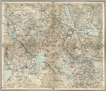
Maps of gmina Stare Juchy

Composite: 137. Arys. (Germany)
1 : 100000 Reichsamt fur Landesaufnahme
137. Arys. (Germany)
1 : 100000 Reichsamt fur Landesaufnahme
Meßtischblatt 2198 : Dippelsee, 1938
1 : 250000 Dippelsee. - Hrsg. 1927, einz. Nachtr. 1932, redakt. Änd. 193. - 1:25000. - [Berlin]: Reichsamt für Landesaufnahme, 1938. - 1 Kt.
Meßtischblatt 2197 : Arys, 1938
1 : 250000 Arys. - Aufn. 1902, 1914/22. hrsg. 1926, einz. Nachtr. 1. - 1:25000. - [Berlin]: Reichsamt für Landesaufnahme, 1938. - 1 Kt.
Meßtischblatt 2199 : Grabnick, 1938
1 : 250000 Grabnick. - Hrsg. 1927, einz. Nachtr. 1932, redakt. Änd. 193. - 1:25000. - [Berlin]: Reichsamt für Landesaufnahme, 1938. - 1 Kt.
Meßtischblatt 2098 : Widminnen, 1932
1 : 250000 Widminnen. - Hrsg. 1927, einz. Nachtr. 1932. - 1:25000. - [Berlin]: Reichsamt für Landesaufnahme, 1932. - 1 Kt.
Meßtischblatt 2097 : Milken, 1938
1 : 250000 Milken. - Hrsg. 1927, einz. Nachtr. 1932, redakt. Änd. 193. - 1:25000. - [Berlin]: Reichsamt für Landesaufnahme, 1938. - 1 Kt.
Meßtischblatt 2099 : Fließdorf, 1938
1 : 250000 Fließdorf. - Hrsg. 1927, einz. Nachtr. 1932, redakt. Änd. [19. - 1:25000. - [Berlin]: Reichsamt für Landesaufnahme, 1938. - 1 Kt.
Meßtischblatt 2299 : Monethen, 1934
1 : 250000 Monethen. - Hrsg. 1912, bericht. 1927, einz. Nachtr. 1932. - 1:25000. - [Berlin]: Reichsamt für Landesaufnahme, 1934. - 1 Kt.
Meßtischblatt 2298 : Seebrücken, 1938
1 : 250000 Seebrücken. - Hrsg. 1912, bericht. 1921, einz. Nachtr. 1938. - 1:25000. - [Berlin]: Reichsamt für Landesaufnahme, 1938. - 1 Kt.
Meßtischblatt 2297 : Stollendorf, 1938
1 : 250000 Stollendorf. - Hrsg. 1912, bericht. 1921, einz. Nachtr. 1938. - 1:25000. - [Berlin]: Reichsamt für Landesaufnahme, 1938. - 1 Kt.
Germany 1:100,000 , Series GSGS 2739, (Sheet 17E)
This map series of which this is part - Germany 1:100,000 , Series GSGS 2739 - are reproductions of German mapping with English marginalia. Great Britain. General Staff. Geographical Section. [London] : [GSGS, War Office]
Regni Borussiae Episcopatus Warmiensis Palatinatus Mariaeburgensis et Culmensis cum Territorio Dantiscano et Ichnographia Urbis Regiomontis].
Mollova mapová sbírka

Schlacht an den Masurischen Seen
1 : 1000000 Masuren Schlacht, Weltkrieg <1914-1918>

28 Lötzen, uit: Special-Karte von Mittel-Europa / nach amtlichen Quellen bearbeitet von W. Liebenow
1 : 300000 titelvariant: W. Liebenow's Mittel-Europa; Annotatie: Titel boven de bladen: W. Liebenow's Mittel-Europa Johannes Wilhelm Liebenow 1822-1897 Frankfurt a. M. : Ludwig Ravenstein
170.1. Bialla (202. Gehsen). (Germany)
1 : 100000 Reichsamt fur Landesaufnahme
202.1. (170. Bialla). Gehsen. (Germany)
1 : 100000 Reichsamt fur Landesaufnahme
Composite: 170.1. Bialla (202. Gehsen) (Germany)
1 : 100000 Reichsamt fur Landesaufnahme
Composite: 106. Grabowen. (Germany)
1 : 100000 Reichsamt fur Landesaufnahme
Meßtischblatt 1997 : Kruglanken, 1938
1 : 250000 Kruglanken. - Aufgen. 1914/22, hrsg. 1927, redakt. Änd. 1938. - 1:25000. - [Berlin]: Reichsamt für Landesaufnahme, 1938. - 1 Kt.
Meßtischblatt 1998 : Adlersdorf, 1938
1 : 250000 Adlersdorf. - Hrsg. 1926, einz. Nachtr. 1928, redakt. Änd. 193. - 1:25000. - [Berlin]: Reichsamt für Landesaufnahme, 1938. - 1 Kt.
Meßtischblatt 1999 : Rogonnen, 1943
1 : 250000 Rogonnen. - Aufn. 1926, hrsg. 1933, letzte Nachtr. 1940. - 1:25000. - [Berlin]: Reichsamt für Landesaufnahme, 1943. - 1 Kt.
Winterschlacht in Masuren
1 : 2000000 Masuren Schlacht, Weltkrieg <1914-1918>
Sect. 11: Allenstein, uit: Geologische Karte des Deutschen Reichs in 27 Blaettern / [von] Richard Lepsius ; Red. von C. Vogel
1 : 500000 Annotatie: Blad 18 ontbreekt; Een aantal bladen op linnen; Een aantal bladen gereviseerd 1913-1914; Annotatie geografische gegevens: Met schaalstokken o.a. in kilometers; Legenda Carl Vogel 1828-1897 Gotha : Justus Perthes
Nr. 21a. Weitere Ergebnisse der Winterschlacht in Masuren
Masuren Weltkrieg <1914-1918>, Ostfront
Provinz Ostpreussen
1 : 1250000 Ostpreußen
Litauisch und Masurisch
Ostpreußen Litauisch, Masurisch
Königsberg, Guttstadt, Biełostok, Suwałki
1 : 750000 Białystok (Polsko : oblast) Konrad, Adalbert K. u. k. Militärgeographisches Institut