Maps of gmina Filipów

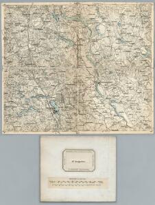
107. Marggrabowa. (Germany)
1 : 100000 Reichsamt fur Landesaufnahme
Composite: 107. Marggrabowa. (Germany)
1 : 100000 Reichsamt fur Landesaufnahme
Meßtischblatt 19101 : Treuburg, 1940
1 : 250000 Treuburg. - Aufn. 1925, hrsg. 1936, redakt. Änd. 1938. - 1:25000. - [Berlin]: Reichsamt für Landesaufnahme, 1940. - 1 Kt.
Meßtischblatt 18101 : Merunen, 1940
1 : 250000 Merunen. - Aufn. 1926, hrsg. 1934, letzte Nachtr. 1940. - 1:25000. - [Berlin]: Reichsamt für Landesaufnahme, 1940. - 1 Kt.
Meßtischblatt 19102 : Woinassen, 1938
1 : 250000 Woinassen. - Aufn. 1925, hrsg. 1928, redakt. Änd. 1938. - 1:25000. - [Berlin]: Reichsamt für Landesaufnahme, 1938. - 1 Kt.
Meßtischblatt 19100 : Reinkental, 1943
1 : 250000 Reinkental. - Aufn. 1926, hrsg. 1931, letzte Nachtr. 1940. - 1:25000. - [Berlin]: Reichsamt für Landesaufnahme, 1943. - 1 Kt.
Meßtischblatt 18100 : Reimannswalde, 1940
1 : 250000 Reimannswalde. - Aufn. 1926, hrsg. 1932, redakt. Änd. 1938. - 1:25000. - [Berlin]: Reichsamt für Landesaufnahme, 1940. - 1 Kt.
Meßtischblatt 17101 : Dubeningen, 1936
1 : 250000 Dubeningen. - Hrsg. 1925, einz. Nachtr. 1928. - 1:25000. - [Berlin]: Reichsamt für Landesaufnahme, 1936. - 1 Kt.
Meßtischblatt 17102 : Unterfelde, 1938
1 : 250000 Unterfelde. - Aufn. 1922, hrsg. 1926, einz. Nachtr. 1928, reda. - 1:25000. - [Berlin]: Reichsamt für Landesaufnahme, 1938. - 1 Kt.
Meßtischblatt 17100 : Gurnen, 1926
1 : 250000 Gurnen. - Aufn. 1921. - 1:25000. - [Berlin]: Reichsamt für Landesaufnahme, 1926. - 1 Kt.
Germany 1:100,000 , Series GSGS 2739, (Sheet 17D)
This map series of which this is part - Germany 1:100,000 , Series GSGS 2739 - are reproductions of German mapping with English marginalia. Great Britain. General Staff. Geographical Section. [London] : [GSGS, War Office]
Suwalki 19, uit: Special-Karte von Mittel-Europa / nach amtlichen Quellen bearbeitet von W. Liebenow
1 : 300000 titelvariant: W. Liebenow's Mittel-Europa; Annotatie: Titel boven de bladen: W. Liebenow's Mittel-Europa Johannes Wilhelm Liebenow 1822-1897 Frankfurt a. M. : Ludwig Ravenstein
78. Mehlkehmen. (Germany)
1 : 100000 Reichsamt fur Landesaufnahme
Composite: 106. Grabowen. (Germany)
1 : 100000 Reichsamt fur Landesaufnahme
Winterschlacht in Masuren
1 : 2000000 Masuren Schlacht, Weltkrieg <1914-1918>
Nr. 21a. Weitere Ergebnisse der Winterschlacht in Masuren
Masuren Weltkrieg <1914-1918>, Ostfront
Sect. 5: Königsberg, uit: Geologische Karte des Deutschen Reichs in 27 Blaettern / [von] Richard Lepsius ; Red. von C. Vogel
1 : 500000 Annotatie: Blad 18 ontbreekt; Een aantal bladen op linnen; Een aantal bladen gereviseerd 1913-1914; Annotatie geografische gegevens: Met schaalstokken o.a. in kilometers; Legenda Carl Vogel 1828-1897 Gotha : Justus Perthes
Provinz Ostpreussen
1 : 1250000 Ostpreußen
Litauisch und Masurisch
Ostpreußen Litauisch, Masurisch
Königsberg, Guttstadt, Biełostok, Suwałki
1 : 750000 Białystok (Polsko : oblast) Konrad, Adalbert K. u. k. Militärgeographisches Institut
Königsberg, Guttstadt, Bielostok, Suwalki
1 : 750000 Białystok (Polsko : oblast) K. k. militär-geographisches Institut
Ost-Preussen.
1 : 935000 Flemming, Carl
Übersichtskarte von Mittel - Europa

Übersichtskarte von Mittel - Europa

Plan einer trigonometrischen Ausmessung welche in den Jahren 1796 und 1797 in Ostpreussen und Lithauen ausgeführt worden
1 : 800000 Landes-Industrie-Comptoir

Provinz Ost - Preussen
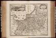
Tabula Prussiae eximia cura conscripta / per Casparum Henneberch Erlichensem et denuo edita per Nicolaum Iohannidem Piscatorem ; A. Goos sculpsit
1 : 720000 Annotatie: Origineel is Blad 93 in atlas factice; Annotatie geografische gegevens: Bevat 3 schaalstokken: Milliaria parva, Milliaria mediocria, Milliaria magna; Inzet: stadsgezicht van Konigsberg Caspar Henneberger 1529-1600; Abraham Goos ca. 1589/90-1643 [Amstelodami] : [Nicolaes Jansz. Visscher]
Tabula PRUSSIAE EXIMIA CURA CONSCRIPTA
1 : 710000 Kaliningrad (Rusko) Hennenberger, Kaspar Goos, Abraham per Nicolaum Iohannidem Piscatorem